Dubnica nad Váhom elevation
Dubnica nad Váhom (Trenčiansky kraj, Okres Ilava), Slovakia elevation is 246 meters and Dubnica nad Váhom elevation in feet is 807 ft above sea level [src 1]. Dubnica nad Váhom is a populated place (feature code) with elevation that is 74 meters (243 ft) smaller than average city elevation in Slovakia.
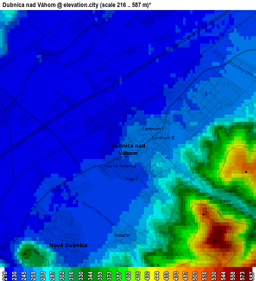
Below is the Elevation map of Dubnica nad Váhom, which displays elevation range with different colors. Scale of the first map is from 216 to 587 m (709 to 1926 ft) with average elevation of 265 meters (=869 ft) [note 1]
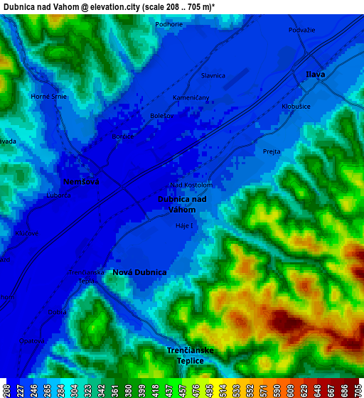
These maps also provides idea of topography and contour of this city, they are displayed at different zoom levels. More info about maps, scale and edge coordinates you can find below images.
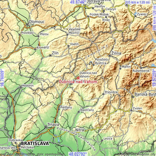
| \ | Map #1 | Map #2 | Topo.Map |
| Scale [m] | 216..587 m | 208..705 m | × |
| Scale [ft] | 709..1926 ft | 682..2313 ft | × |
| Average | 265 m = 869 ft | 312.3 m = 1025 ft | × |
| Width | 6.42 km = 4 mi | 12.83 km = 8 mi | 205.3 km = 127.6 mi |
| Height | 6.42 km = 4 mi | 12.83 km = 8 mi | 205.3 km = 127.6 mi |
| ↑Max Latitude | 48.988656° | 49.017485° | 49.8746° |
| Latitude at center | 48.95981° | 48.95981° | 48.95981° |
| ↓Min Latitude | 48.930948° | 48.902069° | 48.02792° |
| ← Min Longitude | 18.122395° | 18.078449° | 16.76009° |
| Longitude center | 18.16634° | 18.16634° | 18.16634° |
| →Max Longitude | 18.210285° | 18.254231° | 19.57259° |
Nearby cities:
Cities around Dubnica nad Váhom sort by population:
• Trenčín elevation 284 m
11.5 km,  230°
230°
• Považská Bystrica 280 m
25.9 km,  45°
45°
• Nové Mesto nad Váhom 195 m
33.3 km, 227°
• Bánovce nad Bebravou 217 m
27.3 km,  165°
165°
• Púchov 264 m
21.7 km,  32°
32°
• Nová Dubnica 239 m
3.1 km,  207°
207°
• Rajec 448 m
37.4 km,  67°
67°
• Nemšová 226 m
3.6 km,  283°
283°
• Ilava 258 m
6.6 km, 50°
• Bojnice 283 m
36.3 km,  122°
122°
• Trenčianske Teplice 267 m
5.5 km,  179°
179°
• Nováky 236 m
38.6 km,  135°
135°
Multilingual:
 En español:
Dubnica nad Váhom elevación 246 m.
 En France:
Dubnica nad Váhom élévation 246 m.
 Auf Deutsch:
Dubnica nad Váhom höhe über dem Meeresspiegel ist 246 m.

Sources and notes:
- [note 1] Map square and city borders are not equal. Map elevation data is calculated only from area inside that square.
- [src 1] Elevation data from geonames database provided with same terms of usage.
- [src 2] The elevation map of Dubnica nad Váhom is generated using elevation data from NASA's 3 arcsec (90m) resolution SRTM data.
- [src 3] Base (background) map © OpenStreetMap contributors tiles are generated by Geofabrik and OpenTopoMap.
Copyright & License:
This Dubnica nad Váhom Elevation Map is licensed under CC BY-SA. You may reuse any part from this page, if you give a proper credit by linking to this URL:
 More info on terms of use page.