Nižná elevation
Nižná (Žilinský kraj, Okres Tvrdošín), Slovakia elevation is 559 meters and Nižná elevation in feet is 1834 ft above sea level [src 1]. Nižná is a populated place (feature code) with elevation that is 239 meters (784 ft) bigger than average city elevation in Slovakia.
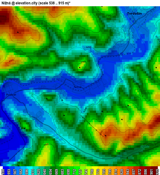
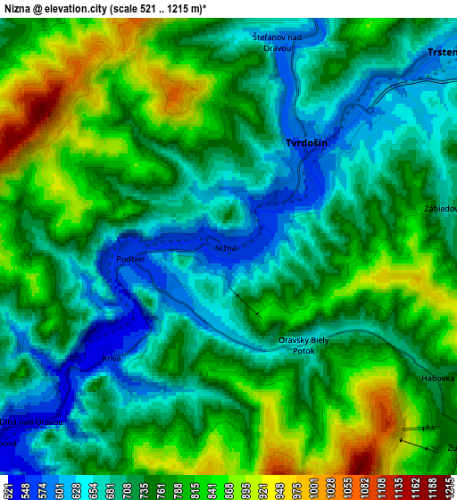
Below is the Elevation map of Nižná, which displays elevation range with different colors. Scale of the first map is from 538 to 915 m (1765 to 3002 ft) with average elevation of 661 meters (=2169 ft) [note 1]
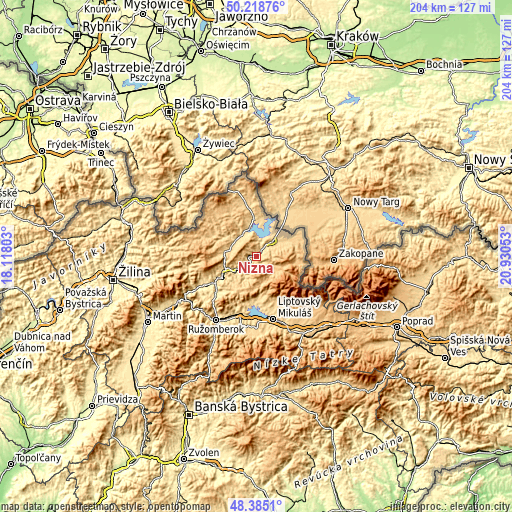
These maps also provides idea of topography and contour of this city, they are displayed at different zoom levels. More info about maps, scale and edge coordinates you can find below images.
| \ | Map #1 | Map #2 | Topo.Map |
| Scale [m] | 538..915 m | 521..1215 m | × |
| Scale [ft] | 1765..3002 ft | 1709..3986 ft | × |
| Average | 661 m = 2169 ft | 749.3 m = 2458 ft | × |
| Width | 6.37 km = 4 mi | 12.74 km = 7.9 mi | 203.9 km = 126.7 mi |
| Height | 6.37 km = 4 mi | 12.74 km = 7.9 mi | 203.9 km = 126.7 mi |
| ↑Max Latitude | 49.339102° | 49.367728° | 50.21876° |
| Latitude at center | 49.31046° | 49.31046° | 49.31046° |
| ↓Min Latitude | 49.281801° | 49.253126° | 48.3851° |
| ← Min Longitude | 19.480335° | 19.436389° | 18.11803° |
| Longitude center | 19.52428° | 19.52428° | 19.52428° |
| →Max Longitude | 19.568225° | 19.612171° | 20.93053° |
Nearby cities:
Cities around Nižná sort by population:
• Liptovský Mikuláš elevation 582 m
26.5 km,  164°
164°
• Ružomberok 481 m
30.6 km,  211°
211°
• Dolný Kubín 520 m
19.5 km,  235°
235°
• Tvrdošín 585 m
3.7 km,  37°
37°
• Námestovo 629 m
11.3 km,  343°
343°
• Liptovský Hrádok 645 m
33.4 km,  154°
154°
• Trstená 607 m
8.5 km,  48°
48°
• Terchová 512 m
36.4 km,  260°
260°
• Oravská Lesná 796 m
25.7 km,  284°
284°
• Lúčky 591 m
22 km,  203°
203°
• Pribylina 770 m
30.6 km,  140°
140°
• Oravský Podzámok 512 m
13.4 km, 244°
Multilingual:
 En español:
Nižná elevación 559 m.
 En France:
Nižná élévation 559 m.


Sources and notes:
- [note 1] Map square and city borders are not equal. Map elevation data is calculated only from area inside that square.
- [src 1] Elevation data from geonames database provided with same terms of usage.
- [src 2] The elevation map of Nižná is generated using elevation data from NASA's 3 arcsec (90m) resolution SRTM data.
- [src 3] Base (background) map © OpenStreetMap contributors tiles are generated by Geofabrik and OpenTopoMap.
Copyright & License:
This Nižná Elevation Map is licensed under CC BY-SA. You may reuse any part from this page, if you give a proper credit by linking to this URL:
 More info on terms of use page.