Lehota pod Vtáčnikom elevation
Lehota pod Vtáčnikom (Trenčiansky kraj, Okres Prievidza), Slovakia elevation is 385 meters and Lehota pod Vtáčnikom elevation in feet is 1263 ft above sea level [src 1]. Lehota pod Vtáčnikom is a seat of a third-order administrative division (feature code) with elevation that is 65 meters (213 ft) bigger than average city elevation in Slovakia.
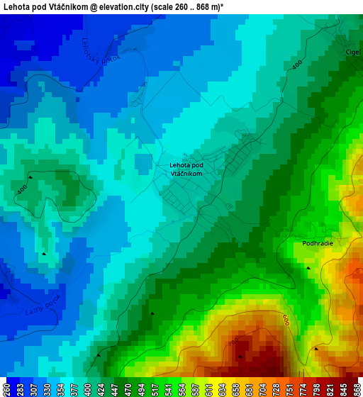
Below is the Elevation map of Lehota pod Vtáčnikom, which displays elevation range with different colors. Scale of the first map is from 260 to 868 m (853 to 2848 ft) with average elevation of 429.6 meters (=1409 ft) [note 1]
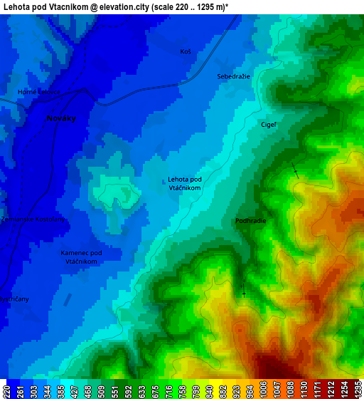
These maps also provides idea of topography and contour of this city, they are displayed at different zoom levels. More info about maps, scale and edge coordinates you can find below images.
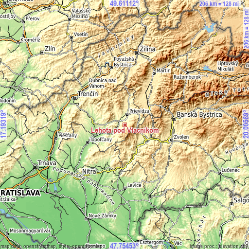
| \ | Map #1 | Map #2 | Topo.Map |
| Scale [m] | 260..868 m | 220..1295 m | × |
| Scale [ft] | 853..2848 ft | 722..4249 ft | × |
| Average | 429.6 m = 1409 ft | 498.5 m = 1635 ft | × |
| Width | 6.45 km = 4 mi | 12.9 km = 8 mi | 206.4 km = 128.3 mi |
| Height | 6.45 km = 4 mi | 12.9 km = 8 mi | 206.4 km = 128.3 mi |
| ↑Max Latitude | 48.720381° | 48.749364° | 49.61112° |
| Latitude at center | 48.69138° | 48.69138° | 48.69138° |
| ↓Min Latitude | 48.662363° | 48.633329° | 47.75453° |
| ← Min Longitude | 18.555495° | 18.511549° | 17.19319° |
| Longitude center | 18.59944° | 18.59944° | 18.59944° |
| →Max Longitude | 18.643385° | 18.687331° | 20.00569° |
Nearby cities:
Cities around Lehota pod Vtáčnikom sort by population:
• Prievidza elevation 295 m
9.5 km,  12°
12°
• Partizánske 192 m
17.3 km,  246°
246°
• Žiar nad Hronom 279 m
21.5 km,  121°
121°
• Bánovce nad Bebravou 217 m
25.3 km,  277°
277°
• Handlová 424 m
12.5 km,  71°
71°
• Nová Baňa 231 m
30 km,  174°
174°
• Žarnovica 230 m
24.9 km,  159°
159°
• Kremnica 566 m
23.5 km,  86°
86°
• Bojnice 283 m
10.5 km,  354°
354°
• Nováky 236 m
5.3 km,  294°
294°
• Topoľčany 174 m
34.8 km, 245°
• Turčianske Teplice 509 m
27 km,  45°
45°
Multilingual:
 En español:
Lehota pod Vtáčnikom elevación 385 m.
 En France:
Lehota pod Vtáčnikom élévation 385 m.
 Auf Deutsch:
Lehota pod Vtáčnikom höhe über dem Meeresspiegel ist 385 m.
 На русском:
Lehota pod Vtáčnikom высота над уровнем моря 385 м
Sources and notes:
- [note 1] Map square and city borders are not equal. Map elevation data is calculated only from area inside that square.
- [src 1] Elevation data from geonames database provided with same terms of usage.
- [src 2] The elevation map of Lehota pod Vtáčnikom is generated using elevation data from NASA's 3 arcsec (90m) resolution SRTM data.
- [src 3] Base (background) map © OpenStreetMap contributors tiles are generated by Geofabrik and OpenTopoMap.
Copyright & License:
This Lehota pod Vtáčnikom Elevation Map is licensed under CC BY-SA. You may reuse any part from this page, if you give a proper credit by linking to this URL:
 More info on terms of use page.