Žilina elevation
Žilina (Žilinský kraj, Okres Žilina), Slovakia elevation is 347 meters and Žilina elevation in feet is 1138 ft above sea level [src 1]. Žilina is a seat of a first-order administrative division (feature code) with elevation that is 27 meters (89 ft) bigger than average city elevation in Slovakia.
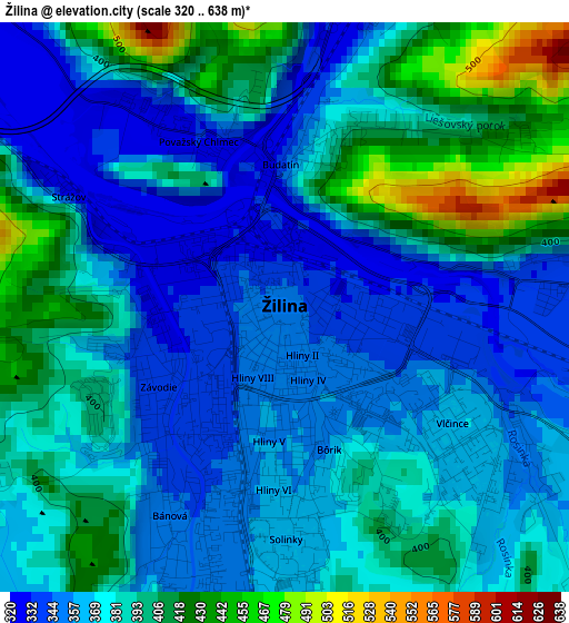
Below is the Elevation map of Žilina, which displays elevation range with different colors. Scale of the first map is from 320 to 638 m (1050 to 2093 ft) with average elevation of 379.3 meters (=1244 ft) [note 1]
These maps also provides idea of topography and contour of this city, they are displayed at different zoom levels. More info about maps, scale and edge coordinates you can find below images.
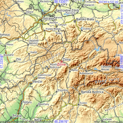
| \ | Map #1 | Map #2 | Topo.Map |
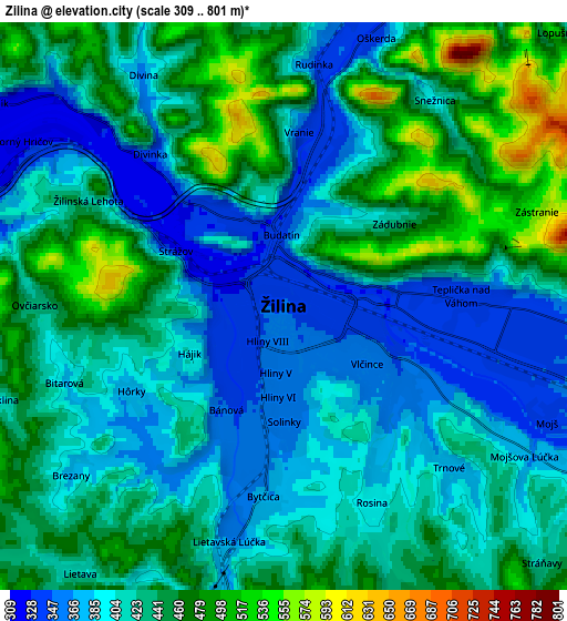
| Scale [m] | 320..638 m | 309..801 m | × |
| Scale [ft] | 1050..2093 ft | 1014..2628 ft | × |
| Average | 379.3 m = 1244 ft | 424.5 m = 1393 ft | × |
| Width | 6.38 km = 4 mi | 12.77 km = 7.9 mi | 204.2 km = 126.9 mi |
| Height | 6.38 km = 4 mi | 12.77 km = 7.9 mi | 204.2 km = 126.9 mi |
| ↑Max Latitude | 49.251843° | 49.280519° | 50.13307° |
| Latitude at center | 49.22315° | 49.22315° | 49.22315° |
| ↓Min Latitude | 49.19444° | 49.165714° | 48.29616° |
| ← Min Longitude | 18.695465° | 18.651519° | 17.33316° |
| Longitude center | 18.73941° | 18.73941° | 18.73941° |
| →Max Longitude | 18.783355° | 18.827301° | 20.14566° |
Nearby cities:
Cities around Žilina sort by population:
• Martin elevation 396 m
22 km,  142°
142°
• Považská Bystrica 280 m
25.7 km,  243°
243°
• Čadca 428 m
23.8 km,  8°
8°
• Púchov 264 m
32 km,  250°
250°
• Kysucké Nové Mesto 356 m
9.1 km,  20°
20°
• Bytča 307 m
13.1 km,  270°
270°
• Turzovka 472 m
21.8 km,  337°
337°
• Vrútky 386 m
17.8 km,  133°
133°
• Rajec 448 m
16.6 km,  205°
205°
• Terchová 512 m
21.4 km,  79°
79°
• Oravská Lesná 796 m
35.8 km,  63°
63°
• Krasňany 383 m
10.8 km,  94°
94°
Multilingual:
 En español:
Žilina elevación 347 m.
 En France:
Žilina élévation 347 m.
 Auf Deutsch:
Sillein, Žilina höhe über dem Meeresspiegel ist 347 m.

Sources and notes:
- [note 1] Map square and city borders are not equal. Map elevation data is calculated only from area inside that square.
- [src 1] Elevation data from geonames database provided with same terms of usage.
- [src 2] The elevation map of Žilina is generated using elevation data from NASA's 3 arcsec (90m) resolution SRTM data.
- [src 3] Base (background) map © OpenStreetMap contributors tiles are generated by Geofabrik and OpenTopoMap.
Copyright & License:
This Žilina Elevation Map is licensed under CC BY-SA. You may reuse any part from this page, if you give a proper credit by linking to this URL:
 More info on terms of use page.