Šempeter pri Gorici elevation
Šempeter pri Gorici (Šempeter-Vrtojba), Slovenia elevation is 74 meters and Šempeter pri Gorici elevation in feet is 243 ft above sea level [src 1]. Šempeter pri Gorici is a seat of a first-order administrative division (feature code) with elevation that is 240 meters (787 ft) smaller than average city elevation in Slovenia.
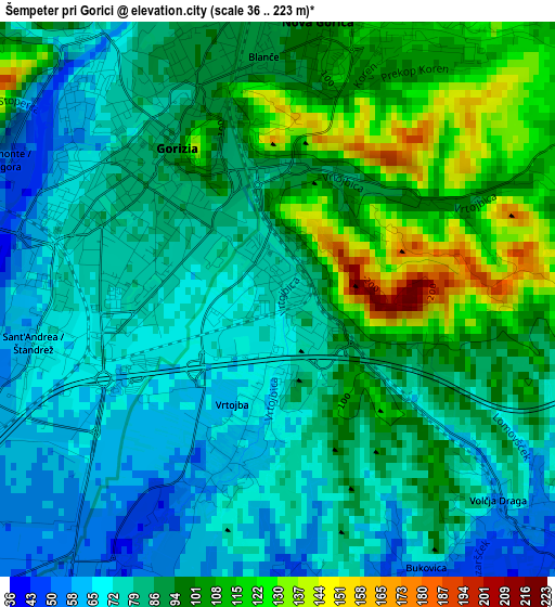
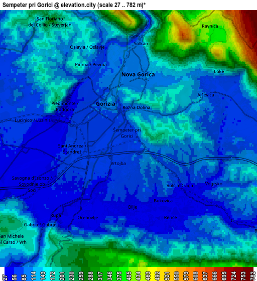
Below is the Elevation map of Šempeter pri Gorici, which displays elevation range with different colors. Scale of the first map is from 36 to 223 m (118 to 732 ft) with average elevation of 88 meters (=289 ft) [note 1]
These maps also provides idea of topography and contour of this city, they are displayed at different zoom levels. More info about maps, scale and edge coordinates you can find below images.
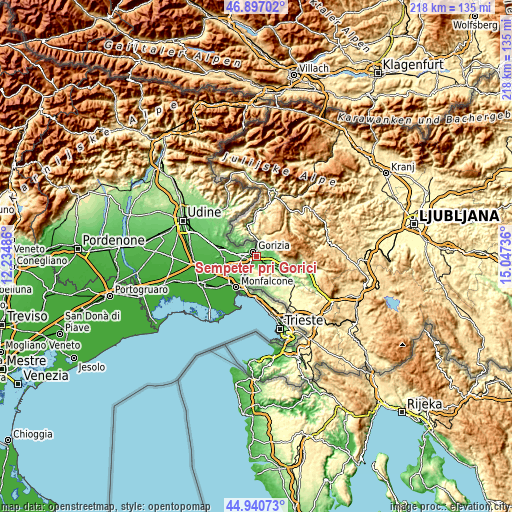
| \ | Map #1 | Map #2 | Topo.Map |
| Scale [m] | 36..223 m | 27..782 m | × |
| Scale [ft] | 118..732 ft | 89..2566 ft | × |
| Average | 88 m = 289 ft | 136.6 m = 448 ft | × |
| Width | 6.8 km = 4.2 mi | 13.59 km = 8.4 mi | 217.5 km = 135.1 mi |
| Height | 6.8 km = 4.2 mi | 13.59 km = 8.4 mi | 217.5 km = 135.1 mi |
| ↑Max Latitude | 45.958059° | 45.9886° | 46.89702° |
| Latitude at center | 45.9275° | 45.9275° | 45.9275° |
| ↓Min Latitude | 45.896925° | 45.866332° | 44.94073° |
| ← Min Longitude | 13.597165° | 13.553219° | 12.23486° |
| Longitude center | 13.64111° | 13.64111° | 13.64111° |
| →Max Longitude | 13.685055° | 13.729001° | 15.04736° |
Nearby cities:
Cities around Šempeter pri Gorici sort by population:
• Nova Gorica elevation 103 m
3.2 km,  10°
10°
• Solkan 101 m
4.9 km, 7°
• Vrtojba 61 m
1.8 km,  197°
197°
• Kromberk 135 m
4.2 km,  27°
27°
• Renče 53 m
4.7 km,  152°
152°
• Miren 52 m
4.4 km,  216°
216°
• Prvačina 73 m
7.3 km,  125°
125°
• Bilje 52 m
3.7 km,  190°
190°
• Šempas 93 m
7.9 km,  87°
87°
• Rožna Dolina 144 m
2.6 km,  52°
52°
• Volčja Draga 74 m
3.6 km, 129°
• Dobrovo 134 m
11.7 km,  310°
310°
Multilingual:
 En español:
Šempeter pri Gorici elevación 74 m.
 En France:
Šempeter pri Gorici élévation 74 m.
 Auf Deutsch:
Šempeter pri Gorici höhe über dem Meeresspiegel ist 74 m.
 На русском:
Šempeter pri Gorici высота над уровнем моря 74 м
Sources and notes:
- [note 1] Map square and city borders are not equal. Map elevation data is calculated only from area inside that square.
- [src 1] Elevation data from geonames database provided with same terms of usage.
- [src 2] The elevation map of Šempeter pri Gorici is generated using elevation data from NASA's 3 arcsec (90m) resolution SRTM data.
- [src 3] Base (background) map © OpenStreetMap contributors tiles are generated by Geofabrik and OpenTopoMap.
Copyright & License:
This Šempeter pri Gorici Elevation Map is licensed under CC BY-SA. You may reuse any part from this page, if you give a proper credit by linking to this URL:
 More info on terms of use page.