Tolmin elevation
Tolmin, Slovenia elevation is 201 meters and Tolmin elevation in feet is 659 ft above sea level [src 1]. Tolmin is a seat of a first-order administrative division (feature code) with elevation that is 113 meters (371 ft) smaller than average city elevation in Slovenia.
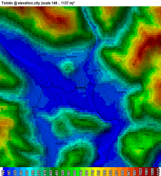
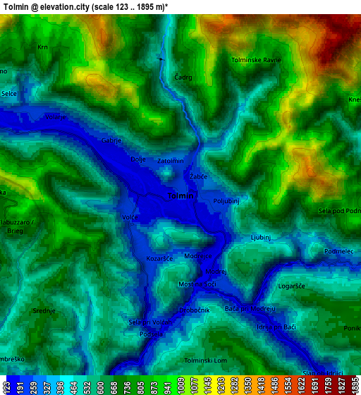
Below is the Elevation map of Tolmin, which displays elevation range with different colors. Scale of the first map is from 149 to 1137 m (489 to 3730 ft) with average elevation of 420.4 meters (=1379 ft) [note 1]
These maps also provides idea of topography and contour of this city, they are displayed at different zoom levels. More info about maps, scale and edge coordinates you can find below images.
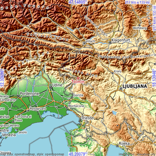
| \ | Map #1 | Map #2 | Topo.Map |
| Scale [m] | 149..1137 m | 123..1895 m | × |
| Scale [ft] | 489..3730 ft | 404..6217 ft | × |
| Average | 420.4 m = 1379 ft | 629.4 m = 2065 ft | × |
| Width | 6.77 km = 4.2 mi | 13.53 km = 8.4 mi | 216.5 km = 134.5 mi |
| Height | 6.77 km = 4.2 mi | 13.53 km = 8.4 mi | 216.5 km = 134.5 mi |
| ↑Max Latitude | 46.213457° | 46.243858° | 47.14805° |
| Latitude at center | 46.18304° | 46.18304° | 46.18304° |
| ↓Min Latitude | 46.152606° | 46.122155° | 45.20079° |
| ← Min Longitude | 13.689265° | 13.645319° | 12.32696° |
| Longitude center | 13.73321° | 13.73321° | 13.73321° |
| →Max Longitude | 13.777155° | 13.821101° | 15.13946° |
Nearby cities:
Cities around Tolmin sort by population:
• Nova Gorica elevation 103 m
26.1 km,  194°
194°
• Solkan 101 m
24.4 km,  195°
195°
• Kromberk 135 m
25.3 km, 191°
• Bohinjska Bistrica 514 m
19.6 km,  59°
59°
• Bovec 465 m
22.1 km,  321°
321°
• Cerkno 318 m
20.2 km,  108°
108°
• Deskle 92 m
17.1 km,  212°
212°
• Kanal 190 m
12.7 km, 214°
• Šempas 93 m
28.1 km,  178°
178°
• Kobarid 237 m
13.9 km,  301°
301°
• Rožna Dolina 144 m
27.3 km, 190°
• Dobrovo 134 m
26.2 km,  217°
217°
Multilingual:
 En español:
Tolmin elevación 201 m.
 En France:
Tolmin élévation 201 m.


Sources and notes:
- [note 1] Map square and city borders are not equal. Map elevation data is calculated only from area inside that square.
- [src 1] Elevation data from geonames database provided with same terms of usage.
- [src 2] The elevation map of Tolmin is generated using elevation data from NASA's 3 arcsec (90m) resolution SRTM data.
- [src 3] Base (background) map © OpenStreetMap contributors tiles are generated by Geofabrik and OpenTopoMap.
Copyright & License:
This Tolmin Elevation Map is licensed under CC BY-SA. You may reuse any part from this page, if you give a proper credit by linking to this URL:
 More info on terms of use page.