Trbovlje elevation
Trbovlje, Slovenia elevation is 285 meters and Trbovlje elevation in feet is 935 ft above sea level [src 1]. Trbovlje is a seat of a first-order administrative division (feature code) with elevation that is 29 meters (95 ft) smaller than average city elevation in Slovenia.
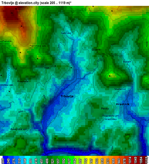
Below is the Elevation map of Trbovlje, which displays elevation range with different colors. Scale of the first map is from 205 to 1119 m (673 to 3671 ft) with average elevation of 466.7 meters (=1531 ft) [note 1]
These maps also provides idea of topography and contour of this city, they are displayed at different zoom levels. More info about maps, scale and edge coordinates you can find below images.
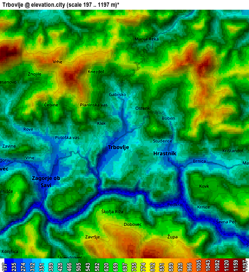
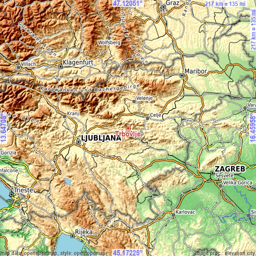
| \ | Map #1 | Map #2 | Topo.Map |
| Scale [m] | 205..1119 m | 197..1197 m | × |
| Scale [ft] | 673..3671 ft | 646..3927 ft | × |
| Average | 466.7 m = 1531 ft | 562.4 m = 1845 ft | × |
| Width | 6.77 km = 4.2 mi | 13.54 km = 8.4 mi | 216.6 km = 134.6 mi |
| Height | 6.77 km = 4.2 mi | 13.54 km = 8.4 mi | 216.6 km = 134.6 mi |
| ↑Max Latitude | 46.185433° | 46.215849° | 47.12051° |
| Latitude at center | 46.155° | 46.155° | 46.155° |
| ↓Min Latitude | 46.12455° | 46.094084° | 45.17225° |
| ← Min Longitude | 15.009385° | 14.965439° | 13.64708° |
| Longitude center | 15.05333° | 15.05333° | 15.05333° |
| →Max Longitude | 15.097275° | 15.141221° | 16.45958° |
Nearby cities:
Cities around Trbovlje sort by population:
• Zagorje ob Savi elevation 244 m
5.1 km,  239°
239°
• Hrastnik 298 m
2.4 km,  114°
114°
• Žalec 260 m
13.7 km,  38°
38°
• Laško 226 m
14 km,  90°
90°
• Šempeter v Savinj. Dolini 271 m
12.4 km,  25°
25°
• Kisovec 277 m
7.2 km,  255°
255°
• Prebold 283 m
9.6 km,  18°
18°
• Dol pri Hrastniku 316 m
4.8 km, 107°
• Izlake 315 m
8 km,  266°
266°
• Zabukovica 330 m
10.5 km,  51°
51°
• Vransko 342 m
12.6 km,  321°
321°
• Tabor 320 m
9.4 km,  343°
343°
Multilingual:
 En español:
Trbovlje elevación 285 m.
 En France:
Trbovlje élévation 285 m.
 Auf Deutsch:
Trbovlje höhe über dem Meeresspiegel ist 285 m.

Sources and notes:
- [note 1] Map square and city borders are not equal. Map elevation data is calculated only from area inside that square.
- [src 1] Elevation data from geonames database provided with same terms of usage.
- [src 2] The elevation map of Trbovlje is generated using elevation data from NASA's 3 arcsec (90m) resolution SRTM data.
- [src 3] Base (background) map © OpenStreetMap contributors tiles are generated by Geofabrik and OpenTopoMap.
Copyright & License:
This Trbovlje Elevation Map is licensed under CC BY-SA. You may reuse any part from this page, if you give a proper credit by linking to this URL:
 More info on terms of use page.