Vnanje Gorice elevation
Vnanje Gorice (Brezovica), Slovenia elevation is 296 meters and Vnanje Gorice elevation in feet is 971 ft above sea level [src 1]. Vnanje Gorice is a populated place (feature code) with elevation that is 18 meters (59 ft) smaller than average city elevation in Slovenia.
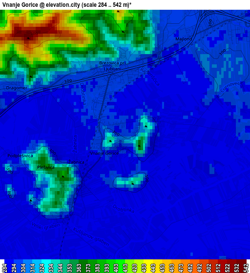
Below is the Elevation map of Vnanje Gorice, which displays elevation range with different colors. Scale of the first map is from 284 to 542 m (932 to 1778 ft) with average elevation of 309.5 meters (=1015 ft) [note 1]
These maps also provides idea of topography and contour of this city, they are displayed at different zoom levels. More info about maps, scale and edge coordinates you can find below images.
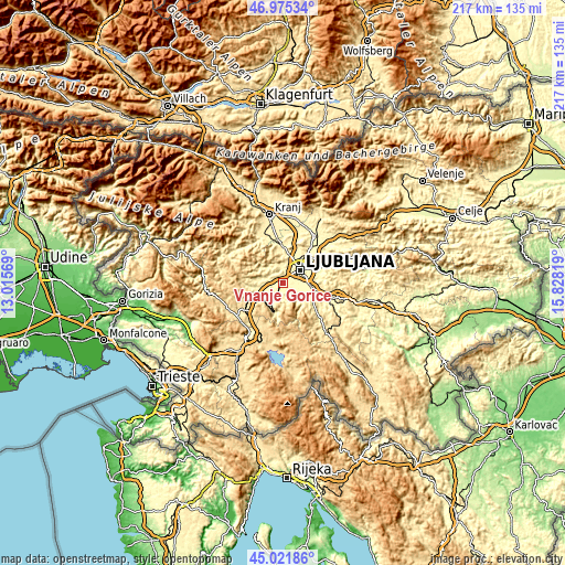
| \ | Map #1 | Topo.Map |
| Scale [m] | 284..542 m | × |
| Scale [ft] | 932..1778 ft | × |
| Average | 309.5 m = 1015 ft | × |
| Width | 6.79 km = 4.2 mi | 217.2 km = 135 mi |
| Height | 6.79 km = 4.2 mi | 217.2 km = 135 mi |
| ↑Max Latitude | 46.037735° | 46.97534° |
| Latitude at center | 46.00722° | 46.00722° |
| ↓Min Latitude | 45.976689° | 45.02186° |
| ← Min Longitude | 14.377995° | 13.01569° |
| Longitude center | 14.42194° | 14.42194° |
| →Max Longitude | 14.465885° | 15.82819° |
Nearby cities:
Cities around Vnanje Gorice sort by population:
• Ljubljana elevation 295 m
8.1 km,  52°
52°
• Vrhnika 297 m
11 km,  243°
243°
• Brezovica pri Ljubljani 454 m
3.4 km,  329°
329°
• Lavrica 293 m
10.5 km,  94°
94°
• Ig 295 m
9.8 km,  122°
122°
• Borovnica 335 m
11.1 km,  204°
204°
• Verd 293 m
10.6 km, 237°
• Notranje Gorice 302 m
2.8 km,  219°
219°
• Log pri Brezovici 444 m
4.4 km,  283°
283°
• Dragomer 292 m
3.2 km,  289°
289°
• Horjul 348 m
9.7 km, 280°
• Dobrova 374 m
4.9 km, 331°
Multilingual:
 En español:
Vnanje Gorice elevación 296 m.
 En France:
Vnanje Gorice élévation 296 m.
 Auf Deutsch:
Vnanje Gorice höhe über dem Meeresspiegel ist 296 m.

Sources and notes:
- [note 1] Map square and city borders are not equal. Map elevation data is calculated only from area inside that square.
- [src 1] Elevation data from geonames database provided with same terms of usage.
- [src 2] The elevation map of Vnanje Gorice is generated using elevation data from NASA's 3 arcsec (90m) resolution SRTM data.
- [src 3] Base (background) map © OpenStreetMap contributors tiles are generated by Geofabrik and OpenTopoMap.
Copyright & License:
This Vnanje Gorice Elevation Map is licensed under CC BY-SA. You may reuse any part from this page, if you give a proper credit by linking to this URL:
 More info on terms of use page.