Bureå elevation
Bureå (Västerbotten, Skellefteå Kommun), Sweden elevation is 6 meters and Bureå elevation in feet is 20 ft above sea level [src 1]. Bureå is a populated place (feature code) with elevation that is 69 meters (226 ft) smaller than average city elevation in Sweden.
Below is the Elevation map of Bureå, which displays elevation range with different colors. Scale of the first map is from 0 to 48 m (0 to 157 ft) with average elevation of 16.3 meters (=53 ft) [note 1]
These maps also provides idea of topography and contour of this city, they are displayed at different zoom levels. More info about maps, scale and edge coordinates you can find below images.
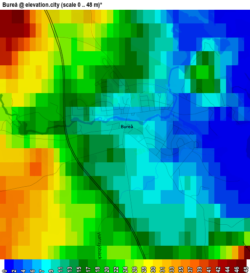
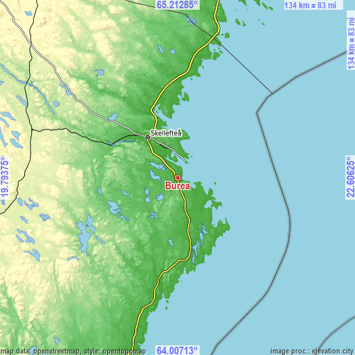
| \ | Map #1 | Topo.Map |
| Scale [m] | 0..48 m | × |
| Scale [ft] | 0..157 ft | × |
| Average | 16.3 m = 53 ft | × |
| Width | 4.19 km = 2.6 mi | 134.1 km = 83.3 mi |
| Height | 4.19 km = 2.6 mi | 134 km = 83.3 mi |
| ↑Max Latitude | 64.635502° | 65.21285° |
| Latitude at center | 64.61667° | 64.61667° |
| ↓Min Latitude | 64.597825° | 64.00713° |
| ← Min Longitude | 21.156055° | 19.79375° |
| Longitude center | 21.2° | 21.2° |
| →Max Longitude | 21.243945° | 22.60625° |
Nearby cities:
Cities around Bureå sort by population:
• Skellefteå elevation 34 m
19 km,  321°
321°
• Ursviken 20 m
10.8 km,  351°
351°
• Viken 87 m
18.2 km,  311°
311°
• Skelleftehamn 10 m
7.6 km,  12°
12°
• Kåge 14 m
26.4 km,  337°
337°
• Robertsfors 62 m
50 km,  199°
199°
• Byske 9 m
37.4 km,  0°
0°
• Forsbacka 144 m
37.2 km,  296°
296°
• Boliden 226 m
47.7 km, 305°
• Långsele 193 m
50.3 km, 296°
• Burträsk 89 m
28.5 km,  247°
247°
• Backa 58 m
41.3 km, 351°
Multilingual:
 En español:
Bureå elevación 6 m.
 En France:
Bureå élévation 6 m.


Sources and notes:
- [note 1] Map square and city borders are not equal. Map elevation data is calculated only from area inside that square.
- [src 1] Elevation data from geonames database provided with same terms of usage.
- [src 2] The elevation map of Bureå is generated using GMTED2010 database with 7.5 arcsec (225m) resolution.
- [src 3] Base (background) map © OpenStreetMap contributors tiles are generated by Geofabrik and OpenTopoMap.
Copyright & License:
This Bureå Elevation Map is licensed under CC BY-SA. You may reuse any part from this page, if you give a proper credit by linking to this URL:
 More info on terms of use page.