Kiruna elevation
Kiruna (Norrbotten, Kiruna Kommun), Sweden elevation is 579 meters and Kiruna elevation in feet is 1900 ft above sea level [src 1]. Kiruna is a seat of a second-order administrative division (feature code) with elevation that is 504 meters (1654 ft) bigger than average city elevation in Sweden.
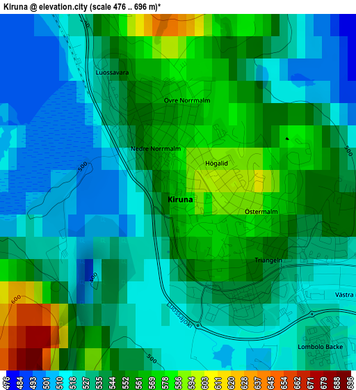
Below is the Elevation map of Kiruna, which displays elevation range with different colors. Scale of the first map is from 476 to 696 m (1562 to 2283 ft) with average elevation of 540.6 meters (=1774 ft) [note 1]
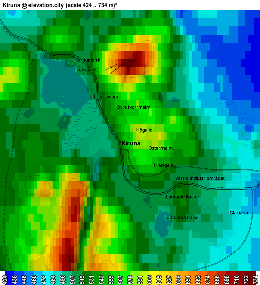
These maps also provides idea of topography and contour of this city, they are displayed at different zoom levels. More info about maps, scale and edge coordinates you can find below images.
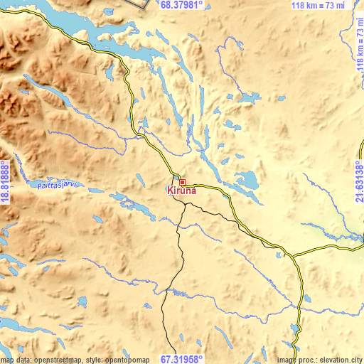
| \ | Map #1 | Map #2 | Topo.Map |
| Scale [m] | 476..696 m | 424..734 m | × |
| Scale [ft] | 1562..2283 ft | 1391..2408 ft | × |
| Average | 540.6 m = 1774 ft | 528.4 m = 1734 ft | × |
| Width | 3.68 km = 2.3 mi | 7.37 km = 4.6 mi | 117.9 km = 73.3 mi |
| Height | 3.68 km = 2.3 mi | 7.37 km = 4.6 mi | 117.9 km = 73.3 mi |
| ↑Max Latitude | 67.872279° | 67.888826° | 68.37981° |
| Latitude at center | 67.85572° | 67.85572° | 67.85572° |
| ↓Min Latitude | 67.839149° | 67.822567° | 67.31958° |
| ← Min Longitude | 20.181185° | 20.137239° | 18.81888° |
| Longitude center | 20.22513° | 20.22513° | 20.22513° |
| →Max Longitude | 20.269075° | 20.313021° | 21.63138° |
Nearby cities:
Cities around Kiruna sort by population:
• Boden elevation 10 m
234.7 km,  164°
164°
• Gällivare 363 m
82.3 km,  167°
167°
• Malmberget 418 m
77.8 km, 166°
• Älvsbyn 33 m
244.7 km, 172°
• Sävast 21 m
241.1 km, 164°
• Jokkmokk 251 m
140 km,  187°
187°
• Pajala 173 m
151.4 km,  118°
118°
• Råneå 25 m
240.1 km, 157°
• Övertorneå 54 m
220.4 km,  137°
137°
• Arjeplog 426 m
224.9 km,  206°
206°
• Töre 30 m
240.6 km,  153°
153°
• Överkalix 41 m
204.2 km, 146°
Multilingual:
 En español:
Kiruna elevación 579 m.
 En France:
Kiruna élévation 579 m.


Sources and notes:
- [note 1] Map square and city borders are not equal. Map elevation data is calculated only from area inside that square.
- [src 1] Elevation data from geonames database provided with same terms of usage.
- [src 2] The elevation map of Kiruna is generated using GMTED2010 database with 7.5 arcsec (225m) resolution.
- [src 3] Base (background) map © OpenStreetMap contributors tiles are generated by Geofabrik and OpenTopoMap.
Copyright & License:
This Kiruna Elevation Map is licensed under CC BY-SA. You may reuse any part from this page, if you give a proper credit by linking to this URL:
 More info on terms of use page.