Luleå elevation
Luleå (Norrbotten, Luleå kommun), Sweden elevation is 17 meters and Luleå elevation in feet is 56 ft above sea level [src 1]. Luleå is a seat of a first-order administrative division (feature code) with elevation that is 58 meters (190 ft) smaller than average city elevation in Sweden.
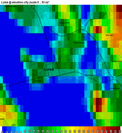
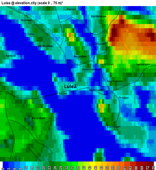
Below is the Elevation map of Luleå, which displays elevation range with different colors. Scale of the first map is from 0 to 53 m (0 to 174 ft) with average elevation of 11.7 meters (=38 ft) [note 1]
These maps also provides idea of topography and contour of this city, they are displayed at different zoom levels. More info about maps, scale and edge coordinates you can find below images.
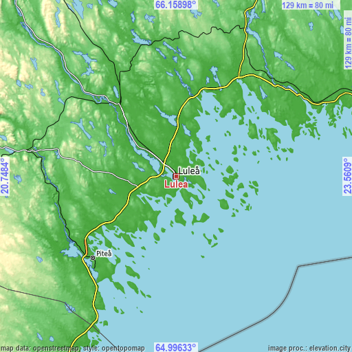
| \ | Map #1 | Map #2 | Topo.Map |
| Scale [m] | 0..53 m | 0..75 m | × |
| Scale [ft] | 0..174 ft | 0..246 ft | × |
| Average | 11.7 m = 38 ft | 16.9 m = 55 ft | × |
| Width | 4.04 km = 2.5 mi | 8.08 km = 5 mi | 129.3 km = 80.3 mi |
| Height | 4.04 km = 2.5 mi | 8.08 km = 5 mi | 129.3 km = 80.3 mi |
| ↑Max Latitude | 65.602309° | 65.620455° | 66.15898° |
| Latitude at center | 65.58415° | 65.58415° | 65.58415° |
| ↓Min Latitude | 65.565979° | 65.547794° | 64.99633° |
| ← Min Longitude | 22.110705° | 22.066759° | 20.7484° |
| Longitude center | 22.15465° | 22.15465° | 22.15465° |
| →Max Longitude | 22.198595° | 22.242541° | 23.5609° |
Nearby cities:
Cities around Luleå sort by population:
• Piteå elevation 6 m
43.1 km,  226°
226°
• Boden 10 m
34.2 km,  321°
321°
• Gammelstad 19 m
9 km,  313°
313°
• Björkskatan 42 m
3.4 km,  17°
17°
• Bergnäset 1 m
2.2 km,  251°
251°
• Södra Sunderbyn 3 m
13 km, 310°
• Sävast 21 m
28.3 km, 316°
• Bergsviken 13 m
47.6 km, 228°
• Råneå 25 m
30.7 km,  11°
11°
• Rosvik 16 m
26.8 km, 231°
• Norrfjärden 3 m
35.3 km,  238°
238°
• Töre 30 m
43 km,  31°
31°
Multilingual:
 En español:
Luleå elevación 17 m.
 En France:
Luleå élévation 17 m.


Sources and notes:
- [note 1] Map square and city borders are not equal. Map elevation data is calculated only from area inside that square.
- [src 1] Elevation data from geonames database provided with same terms of usage.
- [src 2] The elevation map of Luleå is generated using GMTED2010 database with 7.5 arcsec (225m) resolution.
- [src 3] Base (background) map © OpenStreetMap contributors tiles are generated by Geofabrik and OpenTopoMap.
Copyright & License:
This Luleå Elevation Map is licensed under CC BY-SA. You may reuse any part from this page, if you give a proper credit by linking to this URL:
 More info on terms of use page.