Åsa elevation
Åsa (Halland, Kungsbacka Kommun), Sweden elevation is 25 meters and Åsa elevation in feet is 82 ft above sea level [src 1]. Åsa is a populated place (feature code) with elevation that is 50 meters (164 ft) smaller than average city elevation in Sweden.
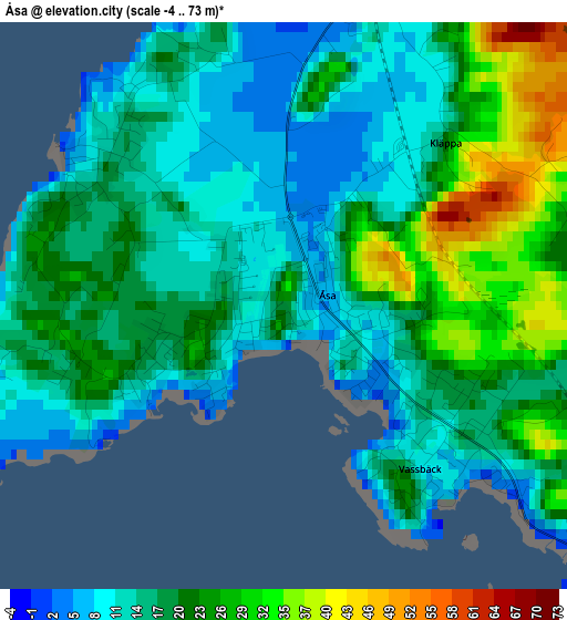
Below is the Elevation map of Åsa, which displays elevation range with different colors. Scale of the first map is from -4 to 73 m (-13 to 240 ft) with average elevation of 18.3 meters (=60 ft) [note 1]
These maps also provides idea of topography and contour of this city, they are displayed at different zoom levels. More info about maps, scale and edge coordinates you can find below images.
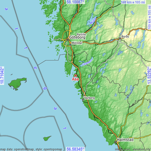
| \ | Map #1 | Map #2 | Topo.Map |
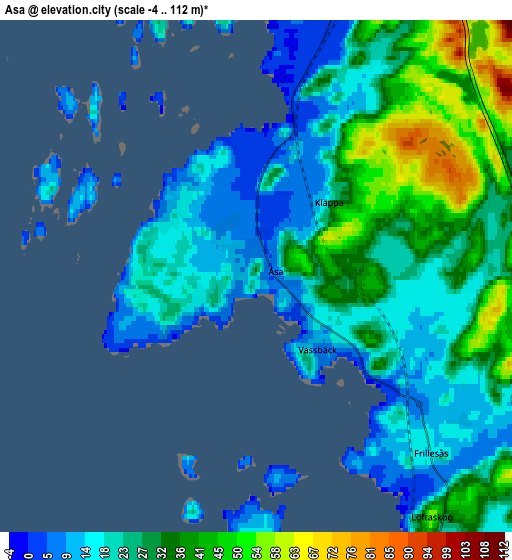
| Scale [m] | -4..73 m | -4..112 m | × |
| Scale [ft] | -13..240 ft | -13..367 ft | × |
| Average | 18.3 m = 60 ft | 26.4 m = 87 ft | × |
| Width | 5.27 km = 3.3 mi | 10.54 km = 6.5 mi | 168.7 km = 104.8 mi |
| Height | 5.27 km = 3.3 mi | 10.54 km = 6.5 mi | 168.7 km = 104.8 mi |
| ↑Max Latitude | 57.373701° | 57.397387° | 58.10087° |
| Latitude at center | 57.35° | 57.35° | 57.35° |
| ↓Min Latitude | 57.326284° | 57.302552° | 56.58345° |
| ← Min Longitude | 12.072725° | 12.028779° | 10.71042° |
| Longitude center | 12.11667° | 12.11667° | 12.11667° |
| →Max Longitude | 12.160615° | 12.204561° | 13.52292° |
Nearby cities:
Cities around Åsa sort by population:
• Kungsbacka elevation 6 m
15.4 km,  350°
350°
• Billdal 17 m
26.5 km,  335°
335°
• Onsala 34 m
9.9 km,  327°
327°
• Lindome 11 m
24.2 km,  355°
355°
• Vallda 44 m
15.8 km, 334°
• Särö 9 m
20.5 km, 327°
• Frillesås 14 m
4.8 km,  141°
141°
• Fjärås kyrkby 26 m
12.6 km,  16°
16°
• Veddige 16 m
16 km,  125°
125°
• Bua 12 m
12.5 km,  178°
178°
• Västra Hagen 4 m
13.6 km,  307°
307°
• Horred 27 m
21.7 km,  88°
88°
Multilingual:
 En español:
Åsa elevación 25 m.
 En France:
Åsa élévation 25 m.


Sources and notes:
- [note 1] Map square and city borders are not equal. Map elevation data is calculated only from area inside that square.
- [src 1] Elevation data from geonames database provided with same terms of usage.
- [src 2] The elevation map of Åsa is generated using elevation data from NASA's 3 arcsec (90m) resolution SRTM data.
- [src 3] Base (background) map © OpenStreetMap contributors tiles are generated by Geofabrik and OpenTopoMap.
Copyright & License:
This Åsa Elevation Map is licensed under CC BY-SA. You may reuse any part from this page, if you give a proper credit by linking to this URL:
 More info on terms of use page.