Björneborg elevation
Björneborg (Värmland, Kristinehamns Kommun), Sweden elevation is 123 meters and Björneborg elevation in feet is 404 ft above sea level [src 1]. Björneborg is a populated place (feature code) with elevation that is 48 meters (157 ft) bigger than average city elevation in Sweden.
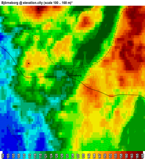
Below is the Elevation map of Björneborg, which displays elevation range with different colors. Scale of the first map is from 100 to 168 m (328 to 551 ft) with average elevation of 132.6 meters (=435 ft) [note 1]
These maps also provides idea of topography and contour of this city, they are displayed at different zoom levels. More info about maps, scale and edge coordinates you can find below images.
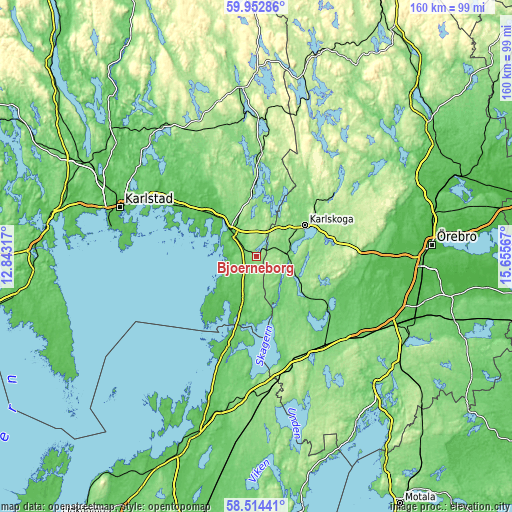
| \ | Map #1 | Topo.Map |
| Scale [m] | 100..168 m | × |
| Scale [ft] | 328..551 ft | × |
| Average | 132.6 m = 435 ft | × |
| Width | 5 km = 3.1 mi | 159.9 km = 99.4 mi |
| Height | 5 km = 3.1 mi | 159.9 km = 99.4 mi |
| ↑Max Latitude | 59.263687° | 59.95286° |
| Latitude at center | 59.24122° | 59.24122° |
| ↓Min Latitude | 59.218738° | 58.51441° |
| ← Min Longitude | 14.205475° | 12.84317° |
| Longitude center | 14.24942° | 14.24942° |
| →Max Longitude | 14.293365° | 15.65567° |
Nearby cities:
Cities around Björneborg sort by population:
• Karlskoga elevation 119 m
18.3 km,  58°
58°
• Kristinehamn 55 m
11.1 km,  313°
313°
• Degerfors 112 m
10.3 km,  92°
92°
• Anderstorp 157 m
39.8 km,  177°
177°
• Laxå 99 m
35.3 km,  143°
143°
• Vintrosa 80 m
39.8 km, 88°
• Storfors 136 m
32.3 km,  2°
2°
• Fjugesta 69 m
36.2 km,  101°
101°
• Skattkärr 63 m
37.9 km,  300°
300°
• Garphyttan 99 m
40.2 km,  79°
79°
• Gullspång 58 m
29.7 km,  197°
197°
• Hova 112 m
43.1 km, 182°
Multilingual:
 En español:
Björneborg elevación 123 m.
 En France:
Björneborg élévation 123 m.
 Auf Deutsch:
Björneborg höhe über dem Meeresspiegel ist 123 m.

Sources and notes:
- [note 1] Map square and city borders are not equal. Map elevation data is calculated only from area inside that square.
- [src 1] Elevation data from geonames database provided with same terms of usage.
- [src 2] The elevation map of Björneborg is generated using elevation data from NASA's 3 arcsec (90m) resolution SRTM data.
- [src 3] Base (background) map © OpenStreetMap contributors tiles are generated by Geofabrik and OpenTopoMap.
Copyright & License:
This Björneborg Elevation Map is licensed under CC BY-SA. You may reuse any part from this page, if you give a proper credit by linking to this URL:
 More info on terms of use page.