Emmaboda elevation
Emmaboda (Kalmar, Emmaboda Kommun), Sweden elevation is 127 meters and Emmaboda elevation in feet is 417 ft above sea level [src 1]. Emmaboda is a seat of a second-order administrative division (feature code) with elevation that is 52 meters (171 ft) bigger than average city elevation in Sweden.
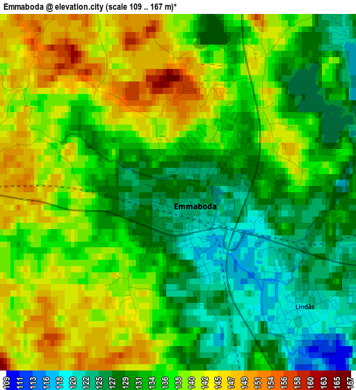
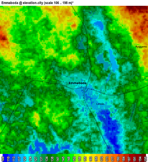
Below is the Elevation map of Emmaboda, which displays elevation range with different colors. Scale of the first map is from 109 to 167 m (358 to 548 ft) with average elevation of 135.1 meters (=443 ft) [note 1]
These maps also provides idea of topography and contour of this city, they are displayed at different zoom levels. More info about maps, scale and edge coordinates you can find below images.
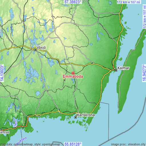
| \ | Map #1 | Map #2 | Topo.Map |
| Scale [m] | 109..167 m | 106..198 m | × |
| Scale [ft] | 358..548 ft | 348..650 ft | × |
| Average | 135.1 m = 443 ft | 139.7 m = 458 ft | × |
| Width | 5.37 km = 3.3 mi | 10.75 km = 6.7 mi | 172 km = 106.9 mi |
| Height | 5.37 km = 3.3 mi | 10.75 km = 6.7 mi | 172 km = 106.9 mi |
| ↑Max Latitude | 56.656842° | 56.680989° | 57.39823° |
| Latitude at center | 56.63268° | 56.63268° | 56.63268° |
| ↓Min Latitude | 56.608502° | 56.584309° | 55.85128° |
| ← Min Longitude | 15.492535° | 15.448589° | 14.13023° |
| Longitude center | 15.53648° | 15.53648° | 15.53648° |
| →Max Longitude | 15.580425° | 15.624371° | 16.94273° |
Nearby cities:
Cities around Emmaboda sort by population:
• Nybro elevation 85 m
25.8 km,  61°
61°
• Smedby 9 m
43.4 km,  83°
83°
• Rödeby 53 m
41.7 km,  172°
172°
• Tingsryd 140 m
36.2 km,  250°
250°
• Hovmantorp 152 m
29.6 km,  305°
305°
• Lessebo 164 m
21 km, 309°
• Torsås 18 m
37.4 km,  130°
130°
• Lenhovda 266 m
43.7 km,  339°
339°
• Ingelstad 160 m
40 km,  289°
289°
• Ljungbyholm 17 m
38.5 km,  89°
89°
• Trekanten 37 m
36.2 km, 78°
• Bergkvara 5 m
42.5 km, 129°
Multilingual:
 En español:
Emmaboda elevación 127 m.
 En France:
Emmaboda élévation 127 m.
 Auf Deutsch:
Emmaboda höhe über dem Meeresspiegel ist 127 m.

Sources and notes:
- [note 1] Map square and city borders are not equal. Map elevation data is calculated only from area inside that square.
- [src 1] Elevation data from geonames database provided with same terms of usage.
- [src 2] The elevation map of Emmaboda is generated using elevation data from NASA's 3 arcsec (90m) resolution SRTM data.
- [src 3] Base (background) map © OpenStreetMap contributors tiles are generated by Geofabrik and OpenTopoMap.
Copyright & License:
This Emmaboda Elevation Map is licensed under CC BY-SA. You may reuse any part from this page, if you give a proper credit by linking to this URL:
 More info on terms of use page.