Hemse elevation
Hemse (Gotland), Sweden elevation is 26 meters and Hemse elevation in feet is 85 ft above sea level [src 1]. Hemse is a populated place (feature code) with elevation that is 49 meters (161 ft) smaller than average city elevation in Sweden.
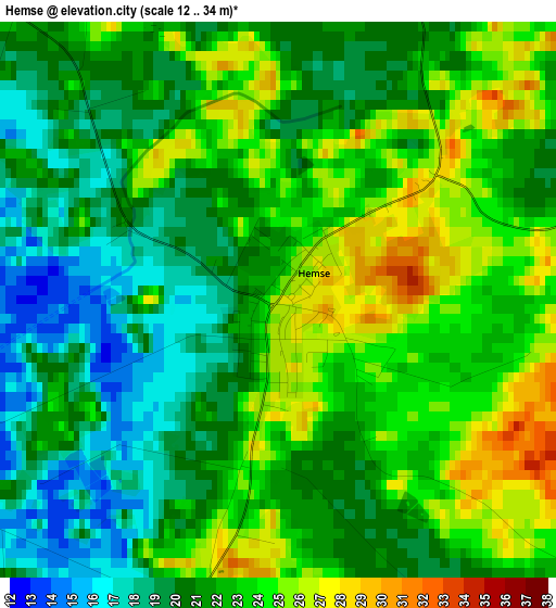
Below is the Elevation map of Hemse, which displays elevation range with different colors. Scale of the first map is from 12 to 34 m (39 to 112 ft) with average elevation of 21.7 meters (=71 ft) [note 1]
These maps also provides idea of topography and contour of this city, they are displayed at different zoom levels. More info about maps, scale and edge coordinates you can find below images.
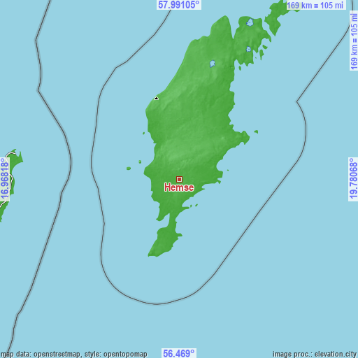
| \ | Map #1 | Topo.Map |
| Scale [m] | 12..34 m | × |
| Scale [ft] | 39..112 ft | × |
| Average | 21.7 m = 71 ft | × |
| Width | 5.29 km = 3.3 mi | 169.2 km = 105.1 mi |
| Height | 5.29 km = 3.3 mi | 169.2 km = 105.1 mi |
| ↑Max Latitude | 57.261653° | 57.99105° |
| Latitude at center | 57.23788° | 57.23788° |
| ↓Min Latitude | 57.214091° | 56.469° |
| ← Min Longitude | 18.330485° | 16.96818° |
| Longitude center | 18.37443° | 18.37443° |
| →Max Longitude | 18.418375° | 19.78068° |
Nearby cities:
Cities around Hemse sort by population:
• Visby elevation 22 m
45.1 km,  354°
354°
• Västervik 11 m
118.8 km,  299°
299°
• Oskarshamn 22 m
115.9 km,  271°
271°
• Södra Sandby 13 m
130.2 km,  235°
235°
• Mönsterås 8 m
118.5 km,  259°
259°
• Borgholm 6 m
111.3 km,  249°
249°
• Blomstermåla 26 m
126.4 km, 257°
• Vibble 43 m
41.4 km, 350°
• Klintehamn 6 m
19.5 km,  328°
328°
• Timmernabben 6 m
121 km, 255°
• Påskallavik 21 m
116.2 km, 266°
• Gunnebo 31 m
122.3 km, 295°
Multilingual:
 En español:
Hemse elevación 26 m.
 En France:
Hemse élévation 26 m.


Sources and notes:
- [note 1] Map square and city borders are not equal. Map elevation data is calculated only from area inside that square.
- [src 1] Elevation data from geonames database provided with same terms of usage.
- [src 2] The elevation map of Hemse is generated using elevation data from NASA's 3 arcsec (90m) resolution SRTM data.
- [src 3] Base (background) map © OpenStreetMap contributors tiles are generated by Geofabrik and OpenTopoMap.
Copyright & License:
This Hemse Elevation Map is licensed under CC BY-SA. You may reuse any part from this page, if you give a proper credit by linking to this URL:
 More info on terms of use page.