Höör elevation
Höör (Skåne, Höörs Kommun), Sweden elevation is 81 meters and Höör elevation in feet is 266 ft above sea level [src 1]. Höör is a seat of a second-order administrative division (feature code) with elevation that is 6 meters (20 ft) bigger than average city elevation in Sweden.
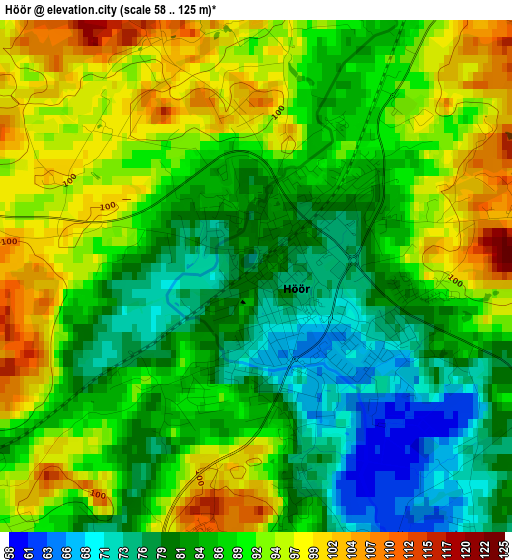
Below is the Elevation map of Höör, which displays elevation range with different colors. Scale of the first map is from 58 to 125 m (190 to 410 ft) with average elevation of 87.8 meters (=288 ft) [note 1]
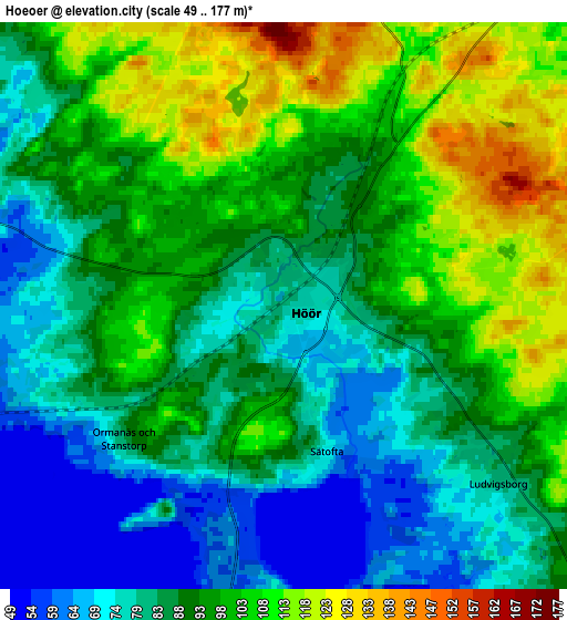
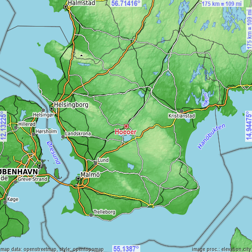
These maps also provides idea of topography and contour of this city, they are displayed at different zoom levels. More info about maps, scale and edge coordinates you can find below images.
| \ | Map #1 | Map #2 | Topo.Map |
| Scale [m] | 58..125 m | 49..177 m | × |
| Scale [ft] | 190..410 ft | 161..581 ft | × |
| Average | 87.8 m = 288 ft | 91.9 m = 302 ft | × |
| Width | 5.47 km = 3.4 mi | 10.95 km = 6.8 mi | 175.2 km = 108.9 mi |
| Height | 5.47 km = 3.4 mi | 10.95 km = 6.8 mi | 175.2 km = 108.9 mi |
| ↑Max Latitude | 55.959048° | 55.98364° | 56.71416° |
| Latitude at center | 55.93444° | 55.93444° | 55.93444° |
| ↓Min Latitude | 55.909817° | 55.885178° | 55.1387° |
| ← Min Longitude | 13.494555° | 13.450609° | 12.13225° |
| Longitude center | 13.5385° | 13.5385° | 13.5385° |
| →Max Longitude | 13.582445° | 13.626391° | 14.94475° |
Nearby cities:
Cities around Höör sort by population:
• Eslöv elevation 68 m
18.1 km,  234°
234°
• Hörby 81 m
11.9 km,  140°
140°
• Perstorp 93 m
24.4 km,  338°
338°
• Tyringe 80 m
25.4 km,  8°
8°
• Svalöv 59 m
26.9 km,  265°
265°
• Ljungbyhed 47 m
24.2 km,  309°
309°
• Sösdala 101 m
14.6 km,  36°
36°
• Marieholm 33 m
25.4 km,  252°
252°
• Löberöd 133 m
17.6 km,  182°
182°
• Stehag 62 m
9.6 km, 247°
• Sätofta 77 m
2.1 km,  160°
160°
• Tormestorp 71 m
23.7 km,  32°
32°
Multilingual:
 En español:
Höör elevación 81 m.
 En France:
Höör élévation 81 m.


Sources and notes:
- [note 1] Map square and city borders are not equal. Map elevation data is calculated only from area inside that square.
- [src 1] Elevation data from geonames database provided with same terms of usage.
- [src 2] The elevation map of Höör is generated using elevation data from NASA's 3 arcsec (90m) resolution SRTM data.
- [src 3] Base (background) map © OpenStreetMap contributors tiles are generated by Geofabrik and OpenTopoMap.
Copyright & License:
This Höör Elevation Map is licensed under CC BY-SA. You may reuse any part from this page, if you give a proper credit by linking to this URL:
 More info on terms of use page.