Krokom elevation
Krokom (Jämtland, Krokoms Kommun), Sweden elevation is 294 meters and Krokom elevation in feet is 965 ft above sea level [src 1]. Krokom is a seat of a second-order administrative division (feature code) with elevation that is 219 meters (719 ft) bigger than average city elevation in Sweden.
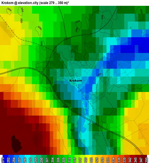
Below is the Elevation map of Krokom, which displays elevation range with different colors. Scale of the first map is from 279 to 350 m (915 to 1148 ft) with average elevation of 310.9 meters (=1020 ft) [note 1]
These maps also provides idea of topography and contour of this city, they are displayed at different zoom levels. More info about maps, scale and edge coordinates you can find below images.
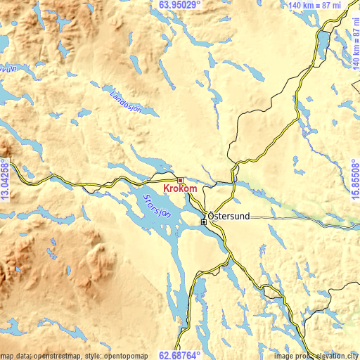
| \ | Map #1 | Topo.Map |
| Scale [m] | 279..350 m | × |
| Scale [ft] | 915..1148 ft | × |
| Average | 310.9 m = 1020 ft | × |
| Width | 4.39 km = 2.7 mi | 140.4 km = 87.2 mi |
| Height | 4.39 km = 2.7 mi | 140.4 km = 87.2 mi |
| ↑Max Latitude | 63.345611° | 63.95029° |
| Latitude at center | 63.32589° | 63.32589° |
| ↓Min Latitude | 63.306156° | 62.68764° |
| ← Min Longitude | 14.404885° | 13.04258° |
| Longitude center | 14.44883° | 14.44883° |
| →Max Longitude | 14.492775° | 15.85508° |
Nearby cities:
Cities around Krokom sort by population:
• Östersund elevation 328 m
18.8 km,  150°
150°
• Brunflo 339 m
33.8 km, 145°
• Strömsund 299 m
80.1 km,  43°
43°
• Åre 379 m
68.7 km,  276°
276°
• Valla 350 m
40.8 km,  307°
307°
• Ås 375 m
10.3 km, 145°
• Bräcke 307 m
80.6 km,  142°
142°
• Järpen 330 m
49.1 km,  272°
272°
• Lit 264 m
19.8 km,  91°
91°
• Hammarstrand 124 m
98.4 km,  104°
104°
• Hammerdal 290 m
53.4 km,  58°
58°
• Hoverberg 300 m
56.9 km,  180°
180°
Multilingual:
 En español:
Krokom elevación 294 m.
 En France:
Krokom élévation 294 m.


Sources and notes:
- [note 1] Map square and city borders are not equal. Map elevation data is calculated only from area inside that square.
- [src 1] Elevation data from geonames database provided with same terms of usage.
- [src 2] The elevation map of Krokom is generated using GMTED2010 database with 7.5 arcsec (225m) resolution.
- [src 3] Base (background) map © OpenStreetMap contributors tiles are generated by Geofabrik and OpenTopoMap.
Copyright & License:
This Krokom Elevation Map is licensed under CC BY-SA. You may reuse any part from this page, if you give a proper credit by linking to this URL:
 More info on terms of use page.