Krylbo elevation
Krylbo (Dalarna, Avesta Kommun), Sweden elevation is 66 meters and Krylbo elevation in feet is 217 ft above sea level [src 1]. Krylbo is a populated place (feature code) with elevation that is 9 meters (30 ft) smaller than average city elevation in Sweden.
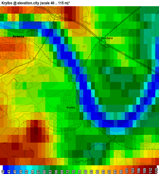
Below is the Elevation map of Krylbo, which displays elevation range with different colors. Scale of the first map is from 40 to 115 m (131 to 377 ft) with average elevation of 74 meters (=243 ft) [note 1]
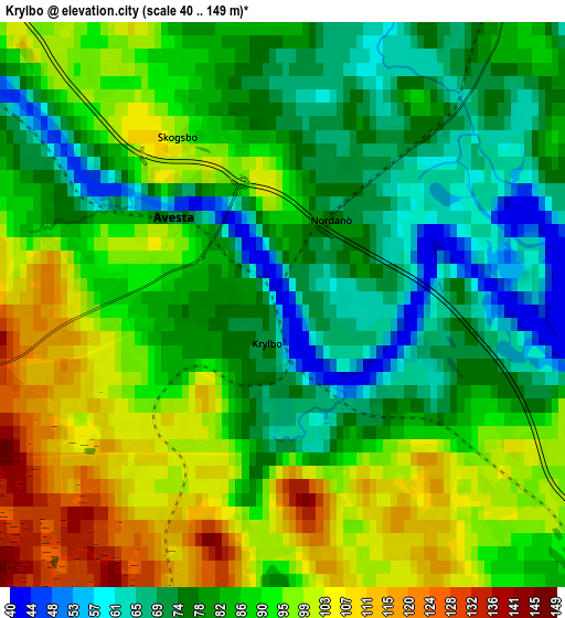
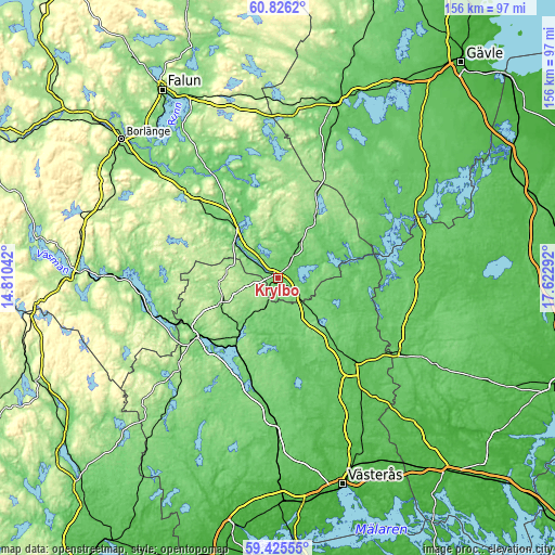
These maps also provides idea of topography and contour of this city, they are displayed at different zoom levels. More info about maps, scale and edge coordinates you can find below images.
| \ | Map #1 | Map #2 | Topo.Map |
| Scale [m] | 40..115 m | 40..149 m | × |
| Scale [ft] | 131..377 ft | 131..489 ft | × |
| Average | 74 m = 243 ft | 86.4 m = 283 ft | × |
| Width | 4.87 km = 3 mi | 9.73 km = 6 mi | 155.7 km = 96.7 mi |
| Height | 4.87 km = 3 mi | 9.73 km = 6 mi | 155.7 km = 96.7 mi |
| ↑Max Latitude | 60.155207° | 60.177069° | 60.8262° |
| Latitude at center | 60.13333° | 60.13333° | 60.13333° |
| ↓Min Latitude | 60.111439° | 60.089533° | 59.42555° |
| ← Min Longitude | 16.172725° | 16.128779° | 14.81042° |
| Longitude center | 16.21667° | 16.21667° | 16.21667° |
| →Max Longitude | 16.260615° | 16.304561° | 17.62292° |
Nearby cities:
Cities around Krylbo sort by population:
• Sala elevation 62 m
32.1 km,  137°
137°
• Avesta 89 m
3.2 km,  289°
289°
• Fagersta 110 m
27.5 km,  238°
238°
• Hedemora 101 m
20.6 km,  322°
322°
• Norberg 124 m
17.9 km, 244°
• Säter 151 m
35.1 km,  312°
312°
• Brunna 55 m
18.3 km, 321°
• Heby 55 m
41.9 km,  121°
121°
• Långshyttan 104 m
36.8 km,  344°
344°
• Ramnäs 76 m
40.8 km,  181°
181°
• Tärnsjö 53 m
39.7 km,  87°
87°
• Horndal 120 m
21.6 km,  30°
30°
Multilingual:
 En español:
Krylbo elevación 66 m.
 En France:
Krylbo élévation 66 m.


Sources and notes:
- [note 1] Map square and city borders are not equal. Map elevation data is calculated only from area inside that square.
- [src 1] Elevation data from geonames database provided with same terms of usage.
- [src 2] The elevation map of Krylbo is generated using GMTED2010 database with 7.5 arcsec (225m) resolution.
- [src 3] Base (background) map © OpenStreetMap contributors tiles are generated by Geofabrik and OpenTopoMap.
Copyright & License:
This Krylbo Elevation Map is licensed under CC BY-SA. You may reuse any part from this page, if you give a proper credit by linking to this URL:
 More info on terms of use page.