Örebro elevation
Örebro, Sweden elevation is 35 meters and Örebro elevation in feet is 115 ft above sea level [src 1]. Örebro is a seat of a first-order administrative division (feature code) with elevation that is 40 meters (131 ft) smaller than average city elevation in Sweden.
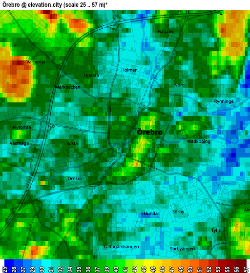
Below is the Elevation map of Örebro, which displays elevation range with different colors. Scale of the first map is from 25 to 57 m (82 to 187 ft) with average elevation of 34.8 meters (=114 ft) [note 1]
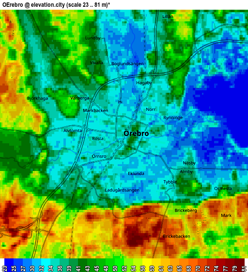
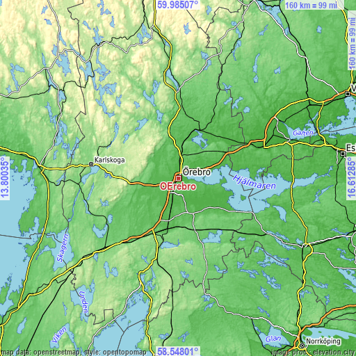
These maps also provides idea of topography and contour of this city, they are displayed at different zoom levels. More info about maps, scale and edge coordinates you can find below images.
| \ | Map #1 | Map #2 | Topo.Map |
| Scale [m] | 25..57 m | 23..81 m | × |
| Scale [ft] | 82..187 ft | 75..266 ft | × |
| Average | 34.8 m = 114 ft | 43.5 m = 143 ft | × |
| Width | 4.99 km = 3.1 mi | 9.99 km = 6.2 mi | 159.8 km = 99.3 mi |
| Height | 4.99 km = 3.1 mi | 9.99 km = 6.2 mi | 159.8 km = 99.3 mi |
| ↑Max Latitude | 59.296566° | 59.318996° | 59.98507° |
| Latitude at center | 59.27412° | 59.27412° | 59.27412° |
| ↓Min Latitude | 59.25166° | 59.229184° | 58.54801° |
| ← Min Longitude | 15.162655° | 15.118709° | 13.80035° |
| Longitude center | 15.2066° | 15.2066° | 15.2066° |
| →Max Longitude | 15.250545° | 15.294491° | 16.61285° |
Nearby cities:
Cities around Örebro sort by population:
• Kumla elevation 57 m
16.7 km,  192°
192°
• Hallsberg 55 m
23.9 km, 193°
• Hovsta 39 m
8.5 km,  3°
3°
• Frövi 45 m
23.3 km,  22°
22°
• Vintrosa 80 m
14.8 km,  259°
259°
• Fjugesta 69 m
22.1 km,  239°
239°
• Hällabrottet 60 m
17.5 km,  181°
181°
• Garphyttan 99 m
15.2 km,  282°
282°
• Pålsboda 94 m
24.3 km,  162°
162°
• Ekeby-Almby 45 m
7.2 km,  102°
102°
• Odensbacken 26 m
22.1 km,  122°
122°
• Sköllersta 53 m
17 km,  153°
153°
Multilingual:
 En español:
Örebro elevación 35 m.
 En France:
Örebro élévation 35 m.


Sources and notes:
- [note 1] Map square and city borders are not equal. Map elevation data is calculated only from area inside that square.
- [src 1] Elevation data from geonames database provided with same terms of usage.
- [src 2] The elevation map of Örebro is generated using elevation data from NASA's 3 arcsec (90m) resolution SRTM data.
- [src 3] Base (background) map © OpenStreetMap contributors tiles are generated by Geofabrik and OpenTopoMap.
Copyright & License:
This Örebro Elevation Map is licensed under CC BY-SA. You may reuse any part from this page, if you give a proper credit by linking to this URL:
 More info on terms of use page.