Oxelösund elevation
Oxelösund (Södermanland, Oxelösunds Kommun), Sweden elevation is 11 meters and Oxelösund elevation in feet is 36 ft above sea level [src 1]. Oxelösund is a seat of a second-order administrative division (feature code) with elevation that is 64 meters (210 ft) smaller than average city elevation in Sweden.
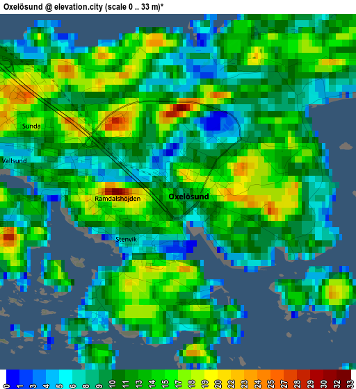
Below is the Elevation map of Oxelösund, which displays elevation range with different colors. Scale of the first map is from 0 to 33 m (0 to 108 ft) with average elevation of 11.9 meters (=39 ft) [note 1]
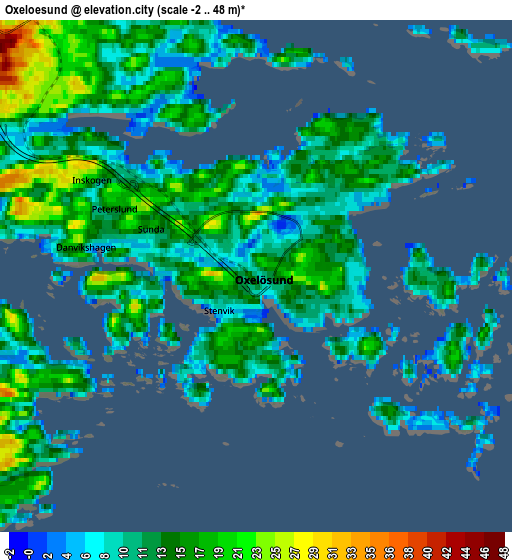
These maps also provides idea of topography and contour of this city, they are displayed at different zoom levels. More info about maps, scale and edge coordinates you can find below images.
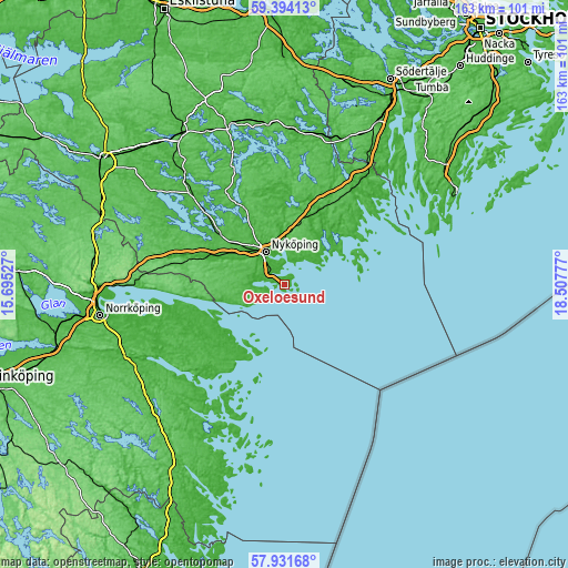
| \ | Map #1 | Map #2 | Topo.Map |
| Scale [m] | 0..33 m | -2..48 m | × |
| Scale [ft] | 0..108 ft | -7..157 ft | × |
| Average | 11.9 m = 39 ft | 13.3 m = 44 ft | × |
| Width | 5.08 km = 3.2 mi | 10.16 km = 6.3 mi | 162.6 km = 101 mi |
| Height | 5.08 km = 3.2 mi | 10.16 km = 6.3 mi | 162.6 km = 101 mi |
| ↑Max Latitude | 58.693412° | 58.716239° | 59.39413° |
| Latitude at center | 58.67057° | 58.67057° | 58.67057° |
| ↓Min Latitude | 58.647713° | 58.624841° | 57.93168° |
| ← Min Longitude | 17.057575° | 17.013629° | 15.69527° |
| Longitude center | 17.10152° | 17.10152° | 17.10152° |
| →Max Longitude | 17.145465° | 17.189411° | 18.50777° |
Nearby cities:
Cities around Oxelösund sort by population:
• Nyköping elevation 20 m
10.6 km,  329°
329°
• Trosa 8 m
35.9 km,  45°
45°
• Gnesta 19 m
43.6 km,  16°
16°
• Krokek 45 m
42.4 km,  270°
270°
• Arnö 16 m
7.7 km,  324°
324°
• Vagnhärad 19 m
37.8 km,  35°
35°
• Bara 20 m
2.5 km,  305°
305°
• Stigtomta 46 m
23.3 km, 308°
• Hölö 47 m
45.8 km,  32°
32°
• Svalsta 30 m
15.6 km,  300°
300°
• Mölnbo 57 m
45.9 km, 23°
• Olstorp 21 m
31.5 km, 301°
Multilingual:
 En español:
Oxelösund elevación 11 m.
 En France:
Oxelösund élévation 11 m.
 Auf Deutsch:
Oxelösund höhe über dem Meeresspiegel ist 11 m.

Sources and notes:
- [note 1] Map square and city borders are not equal. Map elevation data is calculated only from area inside that square.
- [src 1] Elevation data from geonames database provided with same terms of usage.
- [src 2] The elevation map of Oxelösund is generated using elevation data from NASA's 3 arcsec (90m) resolution SRTM data.
- [src 3] Base (background) map © OpenStreetMap contributors tiles are generated by Geofabrik and OpenTopoMap.
Copyright & License:
This Oxelösund Elevation Map is licensed under CC BY-SA. You may reuse any part from this page, if you give a proper credit by linking to this URL:
 More info on terms of use page.