Tomelilla elevation
Tomelilla (Skåne, Tomelilla Kommun), Sweden elevation is 65 meters and Tomelilla elevation in feet is 213 ft above sea level [src 1]. Tomelilla is a seat of a second-order administrative division (feature code) with elevation that is 10 meters (33 ft) smaller than average city elevation in Sweden.
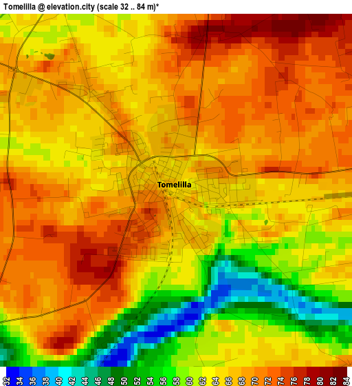
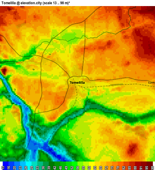
Below is the Elevation map of Tomelilla, which displays elevation range with different colors. Scale of the first map is from 32 to 84 m (105 to 276 ft) with average elevation of 65.1 meters (=214 ft) [note 1]
These maps also provides idea of topography and contour of this city, they are displayed at different zoom levels. More info about maps, scale and edge coordinates you can find below images.
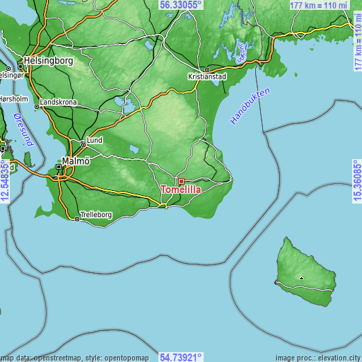
| \ | Map #1 | Map #2 | Topo.Map |
| Scale [m] | 32..84 m | 13..98 m | × |
| Scale [ft] | 105..276 ft | 43..322 ft | × |
| Average | 65.1 m = 214 ft | 64.4 m = 211 ft | × |
| Width | 5.53 km = 3.4 mi | 11.06 km = 6.9 mi | 176.9 km = 109.9 mi |
| Height | 5.53 km = 3.4 mi | 11.06 km = 6.9 mi | 176.9 km = 109.9 mi |
| ↑Max Latitude | 55.567786° | 55.592626° | 56.33055° |
| Latitude at center | 55.54293° | 55.54293° | 55.54293° |
| ↓Min Latitude | 55.518058° | 55.493171° | 54.73921° |
| ← Min Longitude | 13.910655° | 13.866709° | 12.54835° |
| Longitude center | 13.9546° | 13.9546° | 13.9546° |
| →Max Longitude | 13.998545° | 14.042491° | 15.36085° |
Nearby cities:
Cities around Tomelilla sort by population:
• Ystad elevation 8 m
15.2 km,  213°
213°
• Skurup 55 m
29.4 km,  255°
255°
• Sjöbo 50 m
18.4 km,  302°
302°
• Simrishamn 12 m
24.9 km,  86°
86°
• Veberöd 38 m
31.3 km,  288°
288°
• Genarp 41 m
35.5 km,  280°
280°
• Blentarp 55 m
22.7 km, 281°
• Rydsgård 38 m
24.3 km,  251°
251°
• Degeberga 33 m
33.3 km,  14°
14°
• Skivarp 17 m
28.2 km,  240°
240°
• Köpingebro 9 m
9.8 km,  187°
187°
• Gärsnäs 62 m
14.1 km, 87°
Multilingual:
 En español:
Tomelilla elevación 65 m.
 En France:
Tomelilla élévation 65 m.
 Auf Deutsch:
Tomelilla höhe über dem Meeresspiegel ist 65 m.

Sources and notes:
- [note 1] Map square and city borders are not equal. Map elevation data is calculated only from area inside that square.
- [src 1] Elevation data from geonames database provided with same terms of usage.
- [src 2] The elevation map of Tomelilla is generated using elevation data from NASA's 3 arcsec (90m) resolution SRTM data.
- [src 3] Base (background) map © OpenStreetMap contributors tiles are generated by Geofabrik and OpenTopoMap.
Copyright & License:
This Tomelilla Elevation Map is licensed under CC BY-SA. You may reuse any part from this page, if you give a proper credit by linking to this URL:
 More info on terms of use page.