Trollhättan elevation
Trollhättan (Västra Götaland), Sweden elevation is 49 meters and Trollhättan elevation in feet is 161 ft above sea level [src 1]. Trollhättan is a seat of a second-order administrative division (feature code) with elevation that is 26 meters (85 ft) smaller than average city elevation in Sweden.
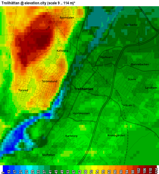
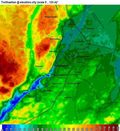
Below is the Elevation map of Trollhättan, which displays elevation range with different colors. Scale of the first map is from 9 to 114 m (30 to 374 ft) with average elevation of 57 meters (=187 ft) [note 1]
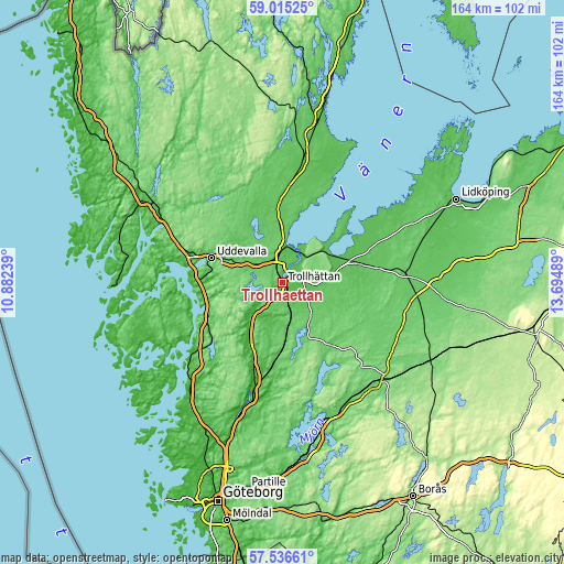
These maps also provides idea of topography and contour of this city, they are displayed at different zoom levels. More info about maps, scale and edge coordinates you can find below images.
| \ | Map #1 | Map #2 | Topo.Map |
| Scale [m] | 9..114 m | 9..123 m | × |
| Scale [ft] | 30..374 ft | 30..404 ft | × |
| Average | 57 m = 187 ft | 62.1 m = 204 ft | × |
| Width | 5.14 km = 3.2 mi | 10.28 km = 6.4 mi | 164.4 km = 102.2 mi |
| Height | 5.14 km = 3.2 mi | 10.28 km = 6.4 mi | 164.4 km = 102.2 mi |
| ↑Max Latitude | 58.306745° | 58.329825° | 59.01525° |
| Latitude at center | 58.28365° | 58.28365° | 58.28365° |
| ↓Min Latitude | 58.26054° | 58.237414° | 57.53661° |
| ← Min Longitude | 12.244695° | 12.200749° | 10.88239° |
| Longitude center | 12.28864° | 12.28864° | 12.28864° |
| →Max Longitude | 12.332585° | 12.376531° | 13.69489° |
Nearby cities:
Cities around Trollhättan sort by population:
• Uddevalla elevation 13 m
21.4 km,  289°
289°
• Vänersborg 54 m
11 km,  10°
10°
• Vargön 59 m
10 km,  36°
36°
• Lilla Edet 41 m
19 km,  208°
208°
• Ljungskile 4 m
22.5 km,  253°
253°
• Grästorp 64 m
23.6 km,  76°
76°
• Sjuntorp 55 m
10.2 km,  204°
204°
• Nossebro 88 m
27.2 km,  113°
113°
• Lödöse 30 m
29.2 km, 195°
• Brålanda 71 m
31.3 km, 6°
• Sollebrunn 77 m
23.5 km,  142°
142°
• Göta 46 m
21.3 km, 202°
Multilingual:
 En español:
Trollhättan elevación 49 m.
 En France:
Trollhättan élévation 49 m.
 Auf Deutsch:
Trollhättan höhe über dem Meeresspiegel ist 49 m.

Sources and notes:
- [note 1] Map square and city borders are not equal. Map elevation data is calculated only from area inside that square.
- [src 1] Elevation data from geonames database provided with same terms of usage.
- [src 2] The elevation map of Trollhättan is generated using elevation data from NASA's 3 arcsec (90m) resolution SRTM data.
- [src 3] Base (background) map © OpenStreetMap contributors tiles are generated by Geofabrik and OpenTopoMap.
Copyright & License:
This Trollhättan Elevation Map is licensed under CC BY-SA. You may reuse any part from this page, if you give a proper credit by linking to this URL:
 More info on terms of use page.