Västra Frölunda elevation
Västra Frölunda (Västra Götaland, Göteborgs stad), Sweden elevation is 4 meters and Västra Frölunda elevation in feet is 13 ft above sea level [src 1]. Västra Frölunda is a populated place (feature code) with elevation that is 71 meters (233 ft) smaller than average city elevation in Sweden.
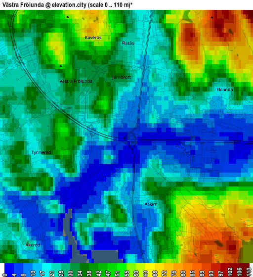
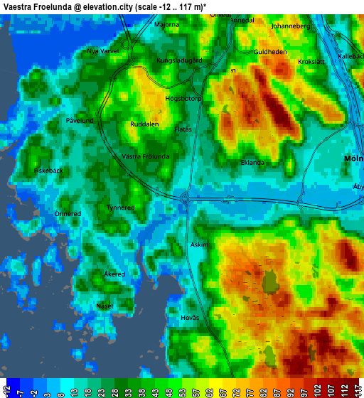
Below is the Elevation map of Västra Frölunda, which displays elevation range with different colors. Scale of the first map is from 0 to 110 m (0 to 361 ft) with average elevation of 32 meters (=105 ft) [note 1]
These maps also provides idea of topography and contour of this city, they are displayed at different zoom levels. More info about maps, scale and edge coordinates you can find below images.
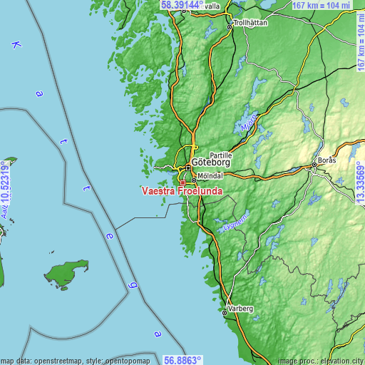
| \ | Map #1 | Map #2 | Topo.Map |
| Scale [m] | 0..110 m | -12..117 m | × |
| Scale [ft] | 0..361 ft | -39..384 ft | × |
| Average | 32 m = 105 ft | 36.8 m = 121 ft | × |
| Width | 5.23 km = 3.2 mi | 10.46 km = 6.5 mi | 167.4 km = 104 mi |
| Height | 5.23 km = 3.2 mi | 10.46 km = 6.5 mi | 167.3 km = 104 mi |
| ↑Max Latitude | 57.670179° | 57.693673° | 58.39144° |
| Latitude at center | 57.64667° | 57.64667° | 57.64667° |
| ↓Min Latitude | 57.623146° | 57.599606° | 56.8863° |
| ← Min Longitude | 11.885495° | 11.841549° | 10.52319° |
| Longitude center | 11.92944° | 11.92944° | 11.92944° |
| →Max Longitude | 11.973385° | 12.017331° | 13.33569° |
Nearby cities:
Cities around Västra Frölunda sort by population:
• Göteborg elevation 10 m
7.1 km,  18°
18°
• Mölndal 9 m
5.1 km,  79°
79°
• Majorna 8 m
5.1 km,  351°
351°
• Mölnlycke 55 m
11.3 km, 83°
• Billdal 17 m
8.9 km,  178°
178°
• Lindome 11 m
12.8 km,  134°
134°
• Torslanda 26 m
12.8 km,  312°
312°
• Kållered 15 m
8.3 km,  119°
119°
• Öjersjö 133 m
13.5 km,  64°
64°
• Andalen 23 m
11.6 km,  300°
300°
• Donsö 12 m
9.3 km,  236°
236°
• Styrsö 20 m
9.2 km,  248°
248°
Multilingual:
 En español:
Västra Frölunda elevación 4 m.
 En France:
Västra Frölunda élévation 4 m.
 Auf Deutsch:
Västra Frölunda höhe über dem Meeresspiegel ist 4 m.

Sources and notes:
- [note 1] Map square and city borders are not equal. Map elevation data is calculated only from area inside that square.
- [src 1] Elevation data from geonames database provided with same terms of usage.
- [src 2] The elevation map of Västra Frölunda is generated using elevation data from NASA's 3 arcsec (90m) resolution SRTM data.
- [src 3] Base (background) map © OpenStreetMap contributors tiles are generated by Geofabrik and OpenTopoMap.
Copyright & License:
This Västra Frölunda Elevation Map is licensed under CC BY-SA. You may reuse any part from this page, if you give a proper credit by linking to this URL:
 More info on terms of use page.