Ad Dabbah elevation
Ad Dabbah (Northern State), Sudan elevation is 242 meters and Ad Dabbah elevation in feet is 794 ft above sea level [src 1]. Ad Dabbah is a populated place (feature code) with elevation that is 207 meters (679 ft) smaller than average city elevation in Sudan.
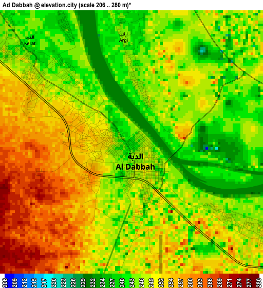
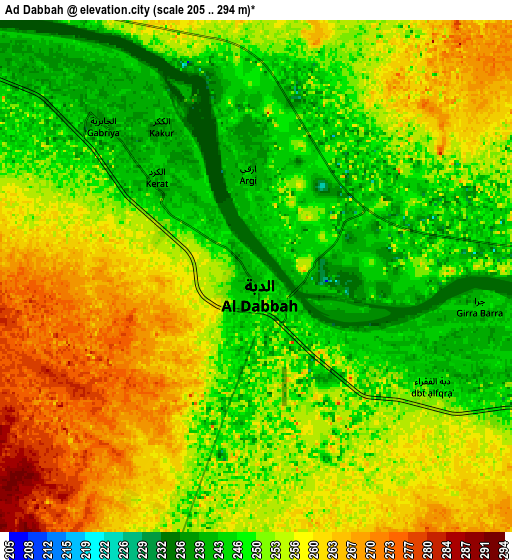
Below is the Elevation map of Ad Dabbah, which displays elevation range with different colors. Scale of the first map is from 206 to 280 m (676 to 919 ft) with average elevation of 248.5 meters (=815 ft) [note 1]
These maps also provides idea of topography and contour of this city, they are displayed at different zoom levels. More info about maps, scale and edge coordinates you can find below images.
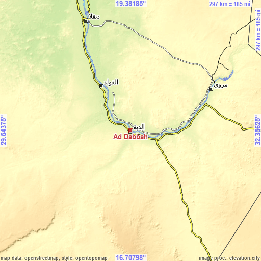
| \ | Map #1 | Map #2 | Topo.Map |
| Scale [m] | 206..280 m | 205..294 m | × |
| Scale [ft] | 676..919 ft | 673..965 ft | × |
| Average | 248.5 m = 815 ft | 253.5 m = 832 ft | × |
| Width | 9.29 km = 5.8 mi | 18.58 km = 11.5 mi | 297.3 km = 184.7 mi |
| Height | 9.29 km = 5.8 mi | 18.58 km = 11.5 mi | 297.3 km = 184.7 mi |
| ↑Max Latitude | 18.091778° | 18.133545° | 19.38185° |
| Latitude at center | 18.05° | 18.05° | 18.05° |
| ↓Min Latitude | 18.008212° | 17.966415° | 16.70798° |
| ← Min Longitude | 30.906055° | 30.862109° | 29.54375° |
| Longitude center | 30.95° | 30.95° | 30.95° |
| →Max Longitude | 30.993945° | 31.037891° | 32.35625° |
Nearby cities:
Cities around Ad Dabbah sort by population:
• Omdurman elevation 391 m
313 km,  148°
148°
• Atbara 358 m
323.6 km,  96°
96°
• Ed Damer 354 m
323.8 km, 98°
• Shendi 366 m
303.8 km,  119°
119°
• Berber 347 m
320.7 km,  90°
90°
• Kuraymah 255 m
110.1 km,  59°
59°
• El Bauga 348 m
313.4 km, 85°
• Dongola 226 m
135.3 km,  338°
338°
• El Matama 366 m
295.7 km, 120°
• Merowe 255 m
102.2 km, 62°
• Argo 224 m
172.5 km, 341°
• Karmah an Nuzul 224 m
184.8 km, 342°
Multilingual:
 En español:
Ad Dabbah elevación 242 m.
 En France:
Ad Dabbah élévation 242 m.
 Auf Deutsch:
Ad Dabbah höhe über dem Meeresspiegel ist 242 m.

Sources and notes:
- [note 1] Map square and city borders are not equal. Map elevation data is calculated only from area inside that square.
- [src 1] Elevation data from geonames database provided with same terms of usage.
- [src 2] The elevation map of Ad Dabbah is generated using elevation data from NASA's 3 arcsec (90m) resolution SRTM data.
- [src 3] Base (background) map © OpenStreetMap contributors tiles are generated by Geofabrik and OpenTopoMap.
Copyright & License:
This Ad Dabbah Elevation Map is licensed under CC BY-SA. You may reuse any part from this page, if you give a proper credit by linking to this URL:
 More info on terms of use page.