Ad-Damazin elevation
Ad-Damazin (Blue Nile), Sudan elevation is 485 meters and Ad-Damazin elevation in feet is 1591 ft above sea level [src 1]. Ad-Damazin is a seat of a first-order administrative division (feature code) with elevation that is 36 meters (118 ft) bigger than average city elevation in Sudan.
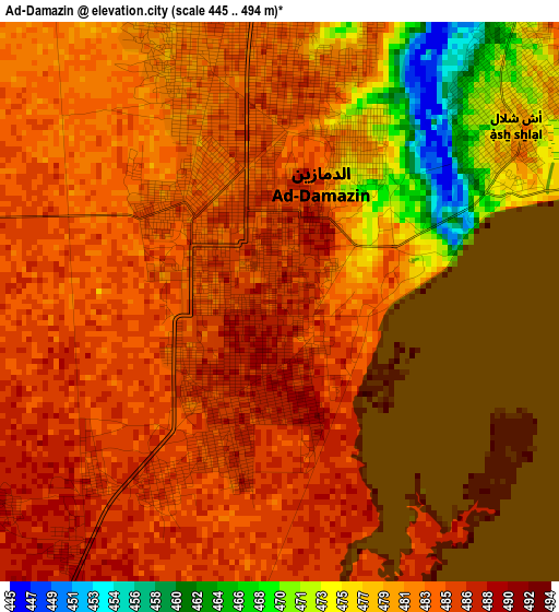
Below is the Elevation map of Ad-Damazin, which displays elevation range with different colors. Scale of the first map is from 445 to 494 m (1460 to 1621 ft) with average elevation of 482.2 meters (=1582 ft) [note 1]
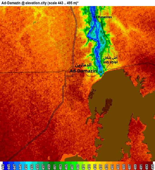
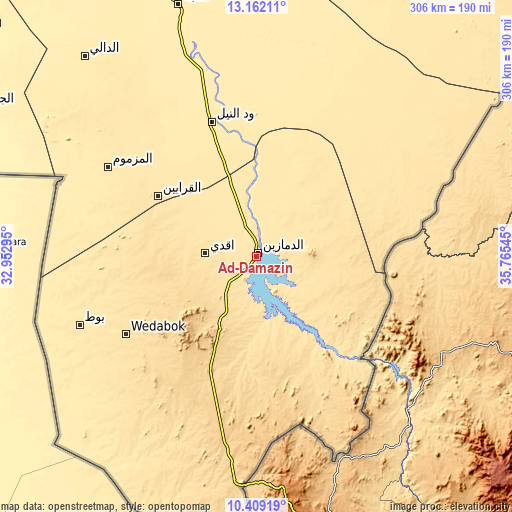
These maps also provides idea of topography and contour of this city, they are displayed at different zoom levels. More info about maps, scale and edge coordinates you can find below images.
| \ | Map #1 | Map #2 | Topo.Map |
| Scale [m] | 445..494 m | 443..495 m | × |
| Scale [ft] | 1460..1621 ft | 1453..1624 ft | × |
| Average | 482.2 m = 1582 ft | 483.4 m = 1586 ft | × |
| Width | 9.57 km = 5.9 mi | 19.13 km = 11.9 mi | 306.1 km = 190.2 mi |
| Height | 9.57 km = 5.9 mi | 19.13 km = 11.9 mi | 306.1 km = 190.2 mi |
| ↑Max Latitude | 11.832115° | 11.875123° | 13.16211° |
| Latitude at center | 11.7891° | 11.7891° | 11.7891° |
| ↓Min Latitude | 11.746078° | 11.70305° | 10.40919° |
| ← Min Longitude | 34.315255° | 34.271309° | 32.95295° |
| Longitude center | 34.3592° | 34.3592° | 34.3592° |
| →Max Longitude | 34.403145° | 34.447091° | 35.76545° |
Nearby cities:
Cities around Ad-Damazin sort by population:
• Kosti elevation 387 m
239.2 km,  309°
309°
• Singa 441 m
158.1 km,  342°
342°
• Rabak 399 m
234.2 km, 311°
• Sinnar 427 m
215.8 km, 336°
• As Sūkī 428 m
177.5 km, 343°
• Ar Ruseris 472 m
9.1 km,  19°
19°
• Maiurno 423 m
195.9 km, 337°
• Al Ḩawātah 445 m
183.4 km,  9°
9°
• Ad Dindar 437 m
158.3 km,  352°
352°
• Marabba 401 m
244.7 km,  284°
284°
• Kurmuk 651 m
138 km,  183°
183°
• Jalqani 454 m
74.9 km, 348°
Multilingual:
 En español:
Ad-Damazin elevación 485 m.
 En France:
Ad-Damazin élévation 485 m.
 Auf Deutsch:
Ad-Damazin höhe über dem Meeresspiegel ist 485 m.

Sources and notes:
- [note 1] Map square and city borders are not equal. Map elevation data is calculated only from area inside that square.
- [src 1] Elevation data from geonames database provided with same terms of usage.
- [src 2] The elevation map of Ad-Damazin is generated using elevation data from NASA's 3 arcsec (90m) resolution SRTM data.
- [src 3] Base (background) map © OpenStreetMap contributors tiles are generated by Geofabrik and OpenTopoMap.
Copyright & License:
This Ad-Damazin Elevation Map is licensed under CC BY-SA. You may reuse any part from this page, if you give a proper credit by linking to this URL:
 More info on terms of use page.