Port Sudan elevation
Port Sudan (Red Sea), Sudan elevation is 10 meters and Port Sudan elevation in feet is 33 ft above sea level [src 1]. Port Sudan is a seat of a first-order administrative division (feature code) with elevation that is 439 meters (1440 ft) smaller than average city elevation in Sudan.
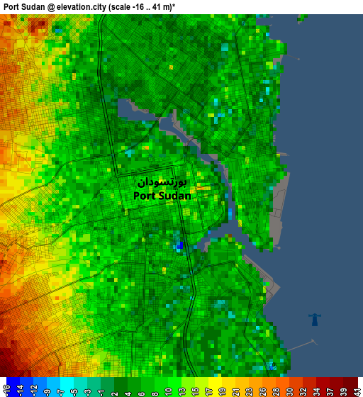
Below is the Elevation map of Port Sudan, which displays elevation range with different colors. Scale of the first map is from -16 to 41 m (-52 to 135 ft) with average elevation of 10.3 meters (=34 ft) [note 1]
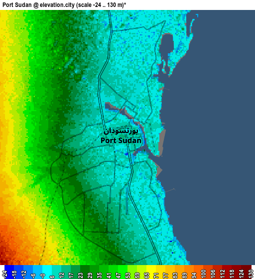
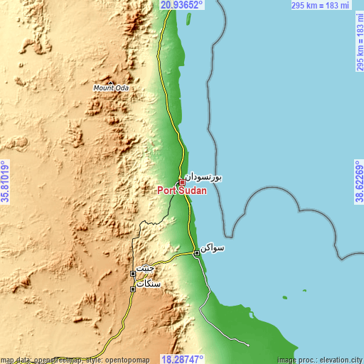
These maps also provides idea of topography and contour of this city, they are displayed at different zoom levels. More info about maps, scale and edge coordinates you can find below images.
| \ | Map #1 | Map #2 | Topo.Map |
| Scale [m] | -16..41 m | -24..130 m | × |
| Scale [ft] | -52..135 ft | -79..427 ft | × |
| Average | 10.3 m = 34 ft | 29.7 m = 97 ft | × |
| Width | 9.21 km = 5.7 mi | 18.41 km = 11.4 mi | 294.5 km = 183 mi |
| Height | 9.21 km = 5.7 mi | 18.41 km = 11.4 mi | 294.6 km = 183.1 mi |
| ↑Max Latitude | 19.658839° | 19.700218° | 20.93652° |
| Latitude at center | 19.61745° | 19.61745° | 19.61745° |
| ↓Min Latitude | 19.57605° | 19.53464° | 18.28747° |
| ← Min Longitude | 37.172495° | 37.128549° | 35.81019° |
| Longitude center | 37.21644° | 37.21644° | 37.21644° |
| →Max Longitude | 37.260385° | 37.304331° | 38.62269° |
Nearby cities:
Cities around Port Sudan sort by population:
• Atbara elevation 358 m
401.4 km,  237°
237°
• Ed Damer 354 m
408.9 km, 236°
• Sawākin 4 m
58.2 km,  167°
167°
• Berber 347 m
383.8 km, 242°
• Tokār 22 m
143.1 km,  157°
157°
• El Bauga 348 m
379.2 km,  246°
246°
• Aroma 443 m
437.9 km,  195°
195°
• Wagar 421 m
399.9 km, 195°
• Gebeit 622 m
186.5 km,  329°
329°
Multilingual:
 En español:
Puerto Sudán elevación 10 m.
 En France:
Port-Soudan élévation 10 m.
 Auf Deutsch:
Bur Sudan höhe über dem Meeresspiegel ist 10 m.

Sources and notes:
- [note 1] Map square and city borders are not equal. Map elevation data is calculated only from area inside that square.
- [src 1] Elevation data from geonames database provided with same terms of usage.
- [src 2] The elevation map of Port Sudan is generated using elevation data from NASA's 3 arcsec (90m) resolution SRTM data.
- [src 3] Base (background) map © OpenStreetMap contributors tiles are generated by Geofabrik and OpenTopoMap.
Copyright & License:
This Port Sudan Elevation Map is licensed under CC BY-SA. You may reuse any part from this page, if you give a proper credit by linking to this URL:
 More info on terms of use page.