Nyala elevation
Nyala (Southern Darfur), Sudan elevation is 661 meters and Nyala elevation in feet is 2169 ft above sea level [src 1]. Nyala is a seat of a first-order administrative division (feature code) with elevation that is 212 meters (696 ft) bigger than average city elevation in Sudan.
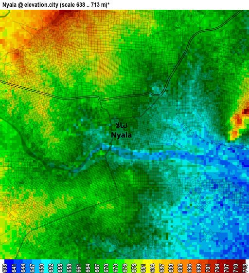
Below is the Elevation map of Nyala, which displays elevation range with different colors. Scale of the first map is from 638 to 713 m (2093 to 2339 ft) with average elevation of 667 meters (=2188 ft) [note 1]
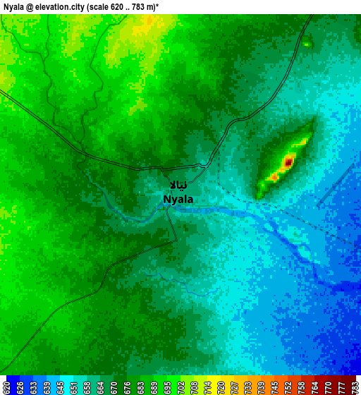
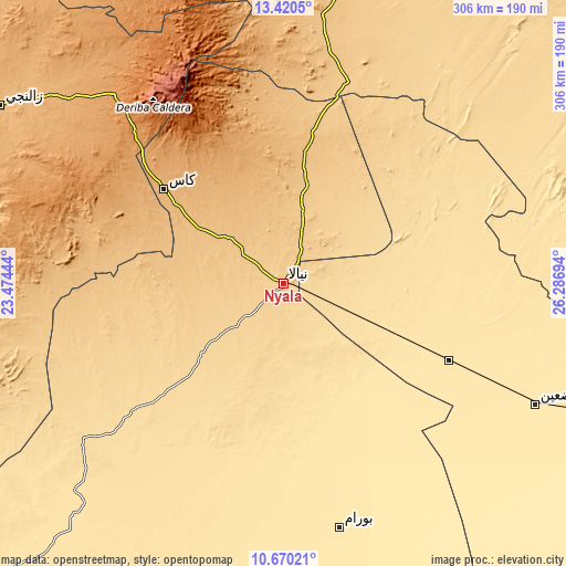
These maps also provides idea of topography and contour of this city, they are displayed at different zoom levels. More info about maps, scale and edge coordinates you can find below images.
| \ | Map #1 | Map #2 | Topo.Map |
| Scale [m] | 638..713 m | 620..783 m | × |
| Scale [ft] | 2093..2339 ft | 2034..2569 ft | × |
| Average | 667 m = 2188 ft | 670.3 m = 2199 ft | × |
| Width | 9.56 km = 5.9 mi | 19.11 km = 11.9 mi | 305.8 km = 190 mi |
| Height | 9.56 km = 5.9 mi | 19.11 km = 11.9 mi | 305.8 km = 190 mi |
| ↑Max Latitude | 12.091854° | 12.134821° | 13.4205° |
| Latitude at center | 12.04888° | 12.04888° | 12.04888° |
| ↓Min Latitude | 12.005899° | 11.962912° | 10.67021° |
| ← Min Longitude | 24.836745° | 24.792799° | 23.47444° |
| Longitude center | 24.88069° | 24.88069° | 24.88069° |
| →Max Longitude | 24.924635° | 24.968581° | 26.28694° |
Nearby cities:
Cities around Nyala sort by population:
• El Daein elevation 478 m
150.4 km,  115°
115°
• El Fasher 748 m
182.8 km,  16°
16°
• Geneina 797 m
306.6 km,  300°
300°
• Gereida 483 m
90.5 km,  161°
161°
• An Nuhūd 571 m
392.6 km,  79°
79°
• Zalingei 891 m
180.5 km, 301°
• Al Mijlad 434 m
330.6 km,  109°
109°
• Al Fūlah 519 m
380 km,  95°
95°
• Umm Kaddadah 601 m
261.1 km,  48°
48°
• Kutum 1159 m
240.3 km,  354°
354°
• El Fula 517 m
378.9 km, 95°
Multilingual:
 En español:
Nyala elevación 661 m.
 En France:
Nyala élévation 661 m.


Sources and notes:
- [note 1] Map square and city borders are not equal. Map elevation data is calculated only from area inside that square.
- [src 1] Elevation data from geonames database provided with same terms of usage.
- [src 2] The elevation map of Nyala is generated using elevation data from NASA's 3 arcsec (90m) resolution SRTM data.
- [src 3] Base (background) map © OpenStreetMap contributors tiles are generated by Geofabrik and OpenTopoMap.
Copyright & License:
This Nyala Elevation Map is licensed under CC BY-SA. You may reuse any part from this page, if you give a proper credit by linking to this URL:
 More info on terms of use page.