Ash Shafā elevation
Ash Shafā (Makkah), Saudi Arabia elevation is 2238 meters and Ash Shafā elevation in feet is 7343 ft above sea level [src 1]. Ash Shafā is a populated place (feature code) with elevation that is 1718 meters (5636 ft) bigger than average city elevation in Saudi Arabia.
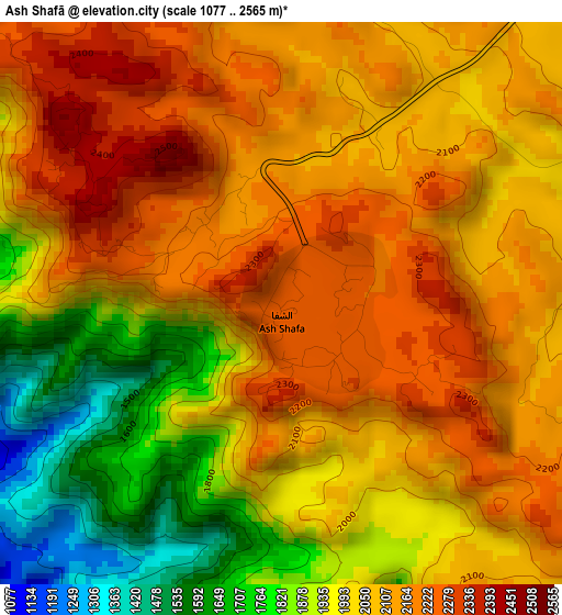
Below is the Elevation map of Ash Shafā, which displays elevation range with different colors. Scale of the first map is from 1077 to 2565 m (3533 to 8415 ft) with average elevation of 2038.4 meters (=6688 ft) [note 1]
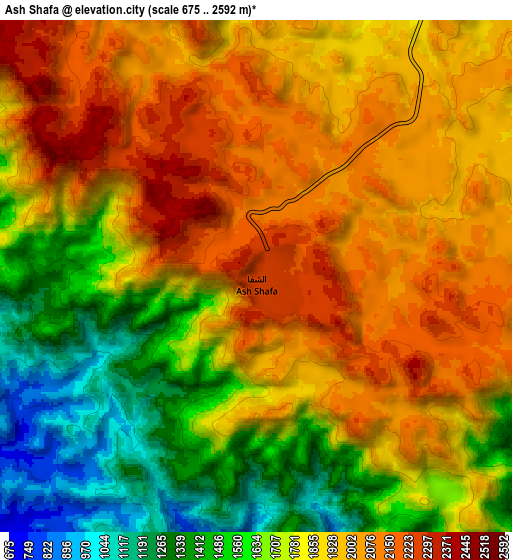
These maps also provides idea of topography and contour of this city, they are displayed at different zoom levels. More info about maps, scale and edge coordinates you can find below images.
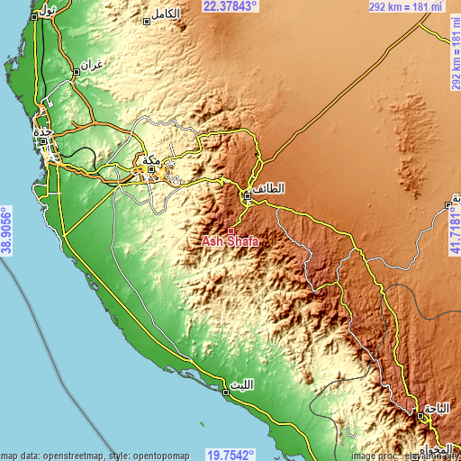
| \ | Map #1 | Map #2 | Topo.Map |
| Scale [m] | 1077..2565 m | 675..2592 m | × |
| Scale [ft] | 3533..8415 ft | 2215..8504 ft | × |
| Average | 2038.4 m = 6688 ft | 1823.5 m = 5983 ft | × |
| Width | 9.12 km = 5.7 mi | 18.24 km = 11.3 mi | 291.8 km = 181.3 mi |
| Height | 9.12 km = 5.7 mi | 18.24 km = 11.3 mi | 291.8 km = 181.3 mi |
| ↑Max Latitude | 21.113101° | 21.154091° | 22.37843° |
| Latitude at center | 21.0721° | 21.0721° | 21.0721° |
| ↓Min Latitude | 21.031088° | 20.990064° | 19.7542° |
| ← Min Longitude | 40.267905° | 40.223959° | 38.9056° |
| Longitude center | 40.31185° | 40.31185° | 40.31185° |
| →Max Longitude | 40.355795° | 40.399741° | 41.7181° |
Nearby cities:
Cities around Ash Shafā sort by population:
• Jeddah elevation 21 m
126.7 km,  294°
294°
• Mecca 333 m
64 km,  308°
308°
• Ta’if 1672 m
24.5 km,  26°
26°
• Al Bahah 2176 m
168.4 km,  134°
134°
• Qal‘at Bīshah 1168 m
266.9 km,  116°
116°
• Rābigh 7 m
232.8 km,  325°
325°
• Turabah 1164 m
137.9 km,  83°
83°
• Al Jumūm 204 m
87.8 km, 313°
• Al Mindak 2006 m
143.3 km,  135°
135°
• Al Muwayh 975 m
212.6 km,  44°
44°
• Al Hadā 1977 m
33 km,  355°
355°
• Tabālah 1233 m
250.7 km, 119°
Multilingual:
 En español:
Ash Shafā elevación 2238 m.
 En France:
Ash Shafā élévation 2238 m.
 Auf Deutsch:
Ash Shafā höhe über dem Meeresspiegel ist 2238 m.

Sources and notes:
- [note 1] Map square and city borders are not equal. Map elevation data is calculated only from area inside that square.
- [src 1] Elevation data from geonames database provided with same terms of usage.
- [src 2] The elevation map of Ash Shafā is generated using elevation data from NASA's 3 arcsec (90m) resolution SRTM data.
- [src 3] Base (background) map © OpenStreetMap contributors tiles are generated by Geofabrik and OpenTopoMap.
Copyright & License:
This Ash Shafā Elevation Map is licensed under CC BY-SA. You may reuse any part from this page, if you give a proper credit by linking to this URL:
 More info on terms of use page.