Al Jubayl elevation
Al Jubayl (Eastern Province), Saudi Arabia elevation is 140 meters and Al Jubayl elevation in feet is 459 ft above sea level [src 1]. Al Jubayl is a populated place (feature code) with elevation that is 380 meters (1247 ft) smaller than average city elevation in Saudi Arabia.
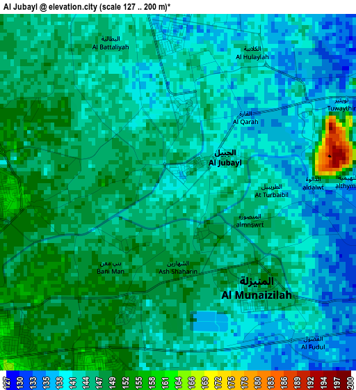
Below is the Elevation map of Al Jubayl, which displays elevation range with different colors. Scale of the first map is from 127 to 200 m (417 to 656 ft) with average elevation of 144.2 meters (=473 ft) [note 1]
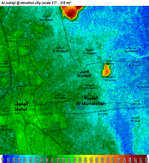
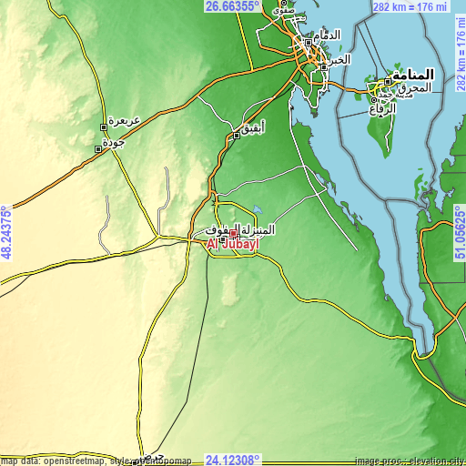
These maps also provides idea of topography and contour of this city, they are displayed at different zoom levels. More info about maps, scale and edge coordinates you can find below images.
| \ | Map #1 | Map #2 | Topo.Map |
| Scale [m] | 127..200 m | 117..215 m | × |
| Scale [ft] | 417..656 ft | 384..705 ft | × |
| Average | 144.2 m = 473 ft | 142.6 m = 468 ft | × |
| Width | 8.83 km = 5.5 mi | 17.66 km = 11 mi | 282.5 km = 175.5 mi |
| Height | 8.83 km = 5.5 mi | 17.66 km = 11 mi | 282.5 km = 175.5 mi |
| ↑Max Latitude | 25.439691° | 25.479369° | 26.66355° |
| Latitude at center | 25.4° | 25.4° | 25.4° |
| ↓Min Latitude | 25.360296° | 25.320579° | 24.12308° |
| ← Min Longitude | 49.606055° | 49.562109° | 48.24375° |
| Longitude center | 49.65° | 49.65° | 49.65° |
| →Max Longitude | 49.693945° | 49.737891° | 51.05625° |
Nearby cities:
Cities around Al Jubayl sort by population:
• Al Hufūf elevation 159 m
7.4 km,  237°
237°
• Al Mubarraz 148 m
6.1 km,  278°
278°
• Abqaiq 103 m
59.4 km,  1°
1°
• Aţ Ţaraf 133 m
8.8 km,  118°
118°
• Al Baţţālīyah 143 m
4.1 km,  335°
335°
• Al Munayzilah 148 m
2.5 km,  137°
137°
• Al Qurayn 140 m
10.5 km,  331°
331°
• Al Qārah 137 m
2.5 km,  42°
42°
• Al Jafr 135 m
7.6 km,  109°
109°
• Al Markaz 128 m
8.4 km,  90°
90°
• Al Muţayrifī 153 m
12.7 km,  313°
313°
• Julayjilah 139 m
12.2 km, 335°
Multilingual:
 En español:
Al Jubayl elevación 140 m.
 En France:
Al Jubayl élévation 140 m.
 Auf Deutsch:
Al Jubayl höhe über dem Meeresspiegel ist 140 m.

Sources and notes:
- [note 1] Map square and city borders are not equal. Map elevation data is calculated only from area inside that square.
- [src 1] Elevation data from geonames database provided with same terms of usage.
- [src 2] The elevation map of Al Jubayl is generated using elevation data from NASA's 3 arcsec (90m) resolution SRTM data.
- [src 3] Base (background) map © OpenStreetMap contributors tiles are generated by Geofabrik and OpenTopoMap.
Copyright & License:
This Al Jubayl Elevation Map is licensed under CC BY-SA. You may reuse any part from this page, if you give a proper credit by linking to this URL:
 More info on terms of use page.