Borovikha elevation
Borovikha (Altai Krai), Russia elevation is 143 meters and Borovikha elevation in feet is 469 ft above sea level [src 1]. Borovikha is a populated place (feature code) with elevation that is 56 meters (184 ft) smaller than average city elevation in Russia.
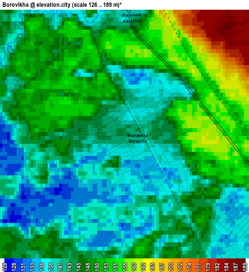
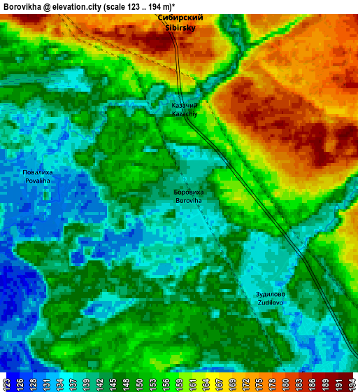
Below is the Elevation map of Borovikha, which displays elevation range with different colors. Scale of the first map is from 126 to 189 m (413 to 620 ft) with average elevation of 146.3 meters (=480 ft) [note 1]
These maps also provides idea of topography and contour of this city, they are displayed at different zoom levels. More info about maps, scale and edge coordinates you can find below images.
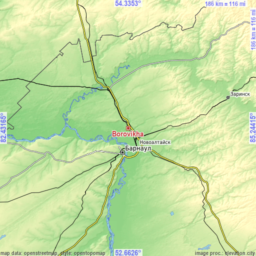
| \ | Map #1 | Map #2 | Topo.Map |
| Scale [m] | 126..189 m | 123..194 m | × |
| Scale [ft] | 413..620 ft | 404..636 ft | × |
| Average | 146.3 m = 480 ft | 151.1 m = 496 ft | × |
| Width | 5.81 km = 3.6 mi | 11.62 km = 7.2 mi | 186 km = 115.6 mi |
| Height | 5.81 km = 3.6 mi | 11.62 km = 7.2 mi | 186 km = 115.6 mi |
| ↑Max Latitude | 53.533327° | 53.559438° | 54.3353° |
| Latitude at center | 53.5072° | 53.5072° | 53.5072° |
| ↓Min Latitude | 53.481057° | 53.454897° | 52.6626° |
| ← Min Longitude | 83.793955° | 83.750009° | 82.43165° |
| Longitude center | 83.8379° | 83.8379° | 83.8379° |
| →Max Longitude | 83.881845° | 83.925791° | 85.24415° |
Nearby cities:
Cities around Borovikha sort by population:
• Barnaul elevation 189 m
17 km,  196°
196°
• Novoaltaysk 147 m
14.4 km,  153°
153°
• Novosilikatnyy 201 m
26.1 km,  212°
212°
• Sibirskiy 181 m
9.5 km,  325°
325°
• Beloyarsk 135 m
8.1 km, 146°
• Pervomayskoye 192 m
26.6 km,  26°
26°
• Zaton 132 m
23.8 km,  184°
184°
• Zudilovo 139 m
4 km,  113°
113°
• Nauchnyy Gorodok 174 m
23.1 km,  245°
245°
• Sannikovo 142 m
20.2 km, 153°
• Gon’ba 164 m
20.1 km,  240°
240°
• Logovskoye 203 m
24.1 km,  93°
93°
Multilingual:
 En español:
Borovikha elevación 143 m.
 En France:
Borovikha élévation 143 m.
 Auf Deutsch:
Borovikha höhe über dem Meeresspiegel ist 143 m.

Sources and notes:
- [note 1] Map square and city borders are not equal. Map elevation data is calculated only from area inside that square.
- [src 1] Elevation data from geonames database provided with same terms of usage.
- [src 2] The elevation map of Borovikha is generated using elevation data from NASA's 3 arcsec (90m) resolution SRTM data.
- [src 3] Base (background) map © OpenStreetMap contributors tiles are generated by Geofabrik and OpenTopoMap.
Copyright & License:
This Borovikha Elevation Map is licensed under CC BY-SA. You may reuse any part from this page, if you give a proper credit by linking to this URL:
 More info on terms of use page.