Dorogino elevation
Dorogino (Novosibirsk Oblast), Russia elevation is 275 meters and Dorogino elevation in feet is 902 ft above sea level [src 1]. Dorogino is a populated place (feature code) with elevation that is 76 meters (249 ft) bigger than average city elevation in Russia.
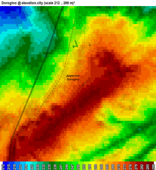
Below is the Elevation map of Dorogino, which displays elevation range with different colors. Scale of the first map is from 212 to 288 m (696 to 945 ft) with average elevation of 258.3 meters (=847 ft) [note 1]
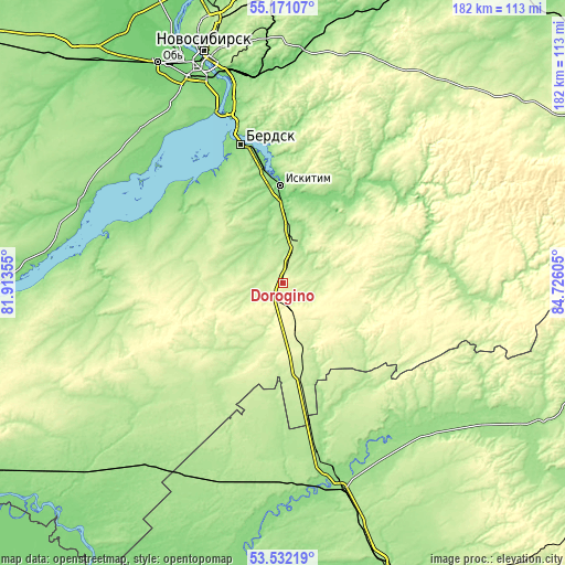
These maps also provides idea of topography and contour of this city, they are displayed at different zoom levels. More info about maps, scale and edge coordinates you can find below images.

| \ | Map #1 | Map #2 | Topo.Map |
| Scale [m] | 212..288 m | 190..304 m | × |
| Scale [ft] | 696..945 ft | 623..997 ft | × |
| Average | 258.3 m = 847 ft | 245.5 m = 805 ft | × |
| Width | 5.69 km = 3.5 mi | 11.39 km = 7.1 mi | 182.2 km = 113.2 mi |
| Height | 5.69 km = 3.5 mi | 11.39 km = 7.1 mi | 182.2 km = 113.2 mi |
| ↑Max Latitude | 54.385399° | 54.410981° | 55.17107° |
| Latitude at center | 54.3598° | 54.3598° | 54.3598° |
| ↓Min Latitude | 54.334185° | 54.308555° | 53.53219° |
| ← Min Longitude | 83.275855° | 83.231909° | 81.91355° |
| Longitude center | 83.3198° | 83.3198° | 83.3198° |
| →Max Longitude | 83.363745° | 83.407691° | 84.72605° |
Nearby cities:
Cities around Dorogino sort by population:
• Berdsk elevation 139 m
46.2 km,  341°
341°
• Iskitim 118 m
30.8 km,  358°
358°
• Akademgorodok 151 m
56.5 km,  345°
345°
• Linëvo 208 m
11.6 km,  18°
18°
• Cherepanovo 276 m
15.8 km,  165°
165°
• Tal’menka 142 m
62.3 km,  164°
164°
• Krasnoobsk 114 m
65.8 km, 341°
• Maslyanino 181 m
57.8 km,  91°
91°
• Kol’tsovo 159 m
64.8 km, 352°
• Yarkovo 144 m
67.9 km,  316°
316°
• Baryshevo 119 m
66.9 km, 352°
• Listvyanskiy 215 m
14.6 km,  52°
52°
Multilingual:
 En español:
Dorogino elevación 275 m.
 En France:
Dorogino élévation 275 m.
 Auf Deutsch:
Dorogino höhe über dem Meeresspiegel ist 275 m.

Sources and notes:
- [note 1] Map square and city borders are not equal. Map elevation data is calculated only from area inside that square.
- [src 1] Elevation data from geonames database provided with same terms of usage.
- [src 2] The elevation map of Dorogino is generated using elevation data from NASA's 3 arcsec (90m) resolution SRTM data.
- [src 3] Base (background) map © OpenStreetMap contributors tiles are generated by Geofabrik and OpenTopoMap.
Copyright & License:
This Dorogino Elevation Map is licensed under CC BY-SA. You may reuse any part from this page, if you give a proper credit by linking to this URL:
 More info on terms of use page.