Gornyak elevation
Gornyak (Chelyabinsk), Russia elevation is 204 meters and Gornyak elevation in feet is 669 ft above sea level [src 1]. Gornyak is a section of populated place (feature code) with elevation that is 5 meters (16 ft) bigger than average city elevation in Russia.
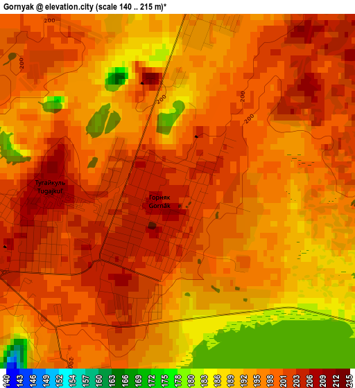
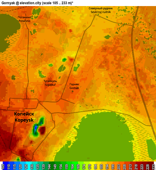
Below is the Elevation map of Gornyak, which displays elevation range with different colors. Scale of the first map is from 140 to 215 m (459 to 705 ft) with average elevation of 196.7 meters (=645 ft) [note 1]
These maps also provides idea of topography and contour of this city, they are displayed at different zoom levels. More info about maps, scale and edge coordinates you can find below images.
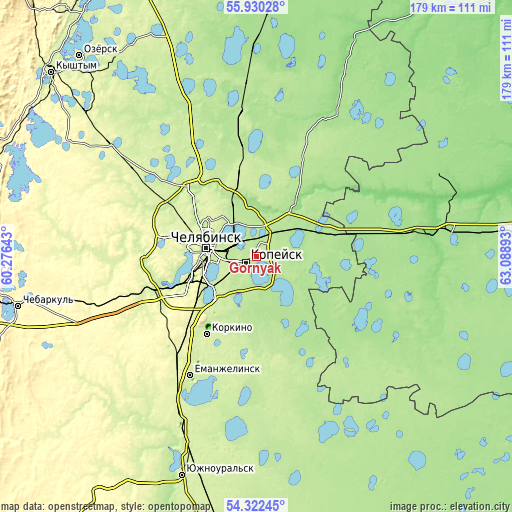
| \ | Map #1 | Map #2 | Topo.Map |
| Scale [m] | 140..215 m | 105..233 m | × |
| Scale [ft] | 459..705 ft | 344..764 ft | × |
| Average | 196.7 m = 645 ft | 196 m = 643 ft | × |
| Width | 5.59 km = 3.5 mi | 11.17 km = 6.9 mi | 178.8 km = 111.1 mi |
| Height | 5.59 km = 3.5 mi | 11.17 km = 6.9 mi | 178.8 km = 111.1 mi |
| ↑Max Latitude | 55.159574° | 55.184671° | 55.93028° |
| Latitude at center | 55.13446° | 55.13446° | 55.13446° |
| ↓Min Latitude | 55.109331° | 55.084185° | 54.32245° |
| ← Min Longitude | 61.638735° | 61.594789° | 60.27643° |
| Longitude center | 61.68268° | 61.68268° | 61.68268° |
| →Max Longitude | 61.726625° | 61.770571° | 63.08893° |
Nearby cities:
Cities around Gornyak sort by population:
• Chelyabinsk elevation 219 m
16.3 km,  277°
277°
• Kopeysk 207 m
4 km,  241°
241°
• Novosineglazovskiy 252 m
22.2 km, 241°
• Roza 232 m
28.1 km,  210°
210°
• Bazhovo 213 m
9.7 km, 210°
• Starokamyshinsk 209 m
12.2 km, 209°
• Miasskoye 155 m
20.7 km,  39°
39°
• Potanino 206 m
6.2 km,  321°
321°
• Zheleznodorozhnyy 223 m
9.2 km,  246°
246°
• Vakhrushevo 196 m
11 km,  11°
11°
• Kanashevo 180 m
25.9 km,  69°
69°
• Selezyan 197 m
27 km,  160°
160°
Multilingual:
 En español:
Gornyak elevación 204 m.
 En France:
Gornyak élévation 204 m.


Sources and notes:
- [note 1] Map square and city borders are not equal. Map elevation data is calculated only from area inside that square.
- [src 1] Elevation data from geonames database provided with same terms of usage.
- [src 2] The elevation map of Gornyak is generated using elevation data from NASA's 3 arcsec (90m) resolution SRTM data.
- [src 3] Base (background) map © OpenStreetMap contributors tiles are generated by Geofabrik and OpenTopoMap.
Copyright & License:
This Gornyak Elevation Map is licensed under CC BY-SA. You may reuse any part from this page, if you give a proper credit by linking to this URL:
 More info on terms of use page.