Ishim elevation
Ishim (Tyumen’ Oblast), Russia elevation is 80 meters and Ishim elevation in feet is 262 ft above sea level [src 1]. Ishim is a populated place (feature code) with elevation that is 119 meters (390 ft) smaller than average city elevation in Russia.
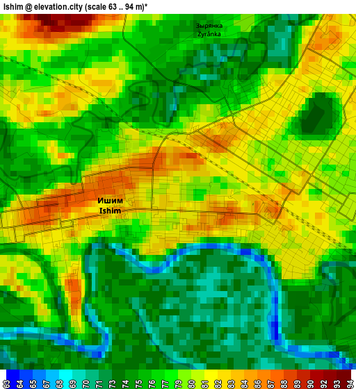
Below is the Elevation map of Ishim, which displays elevation range with different colors. Scale of the first map is from 63 to 94 m (207 to 308 ft) with average elevation of 77.5 meters (=254 ft) [note 1]
These maps also provides idea of topography and contour of this city, they are displayed at different zoom levels. More info about maps, scale and edge coordinates you can find below images.

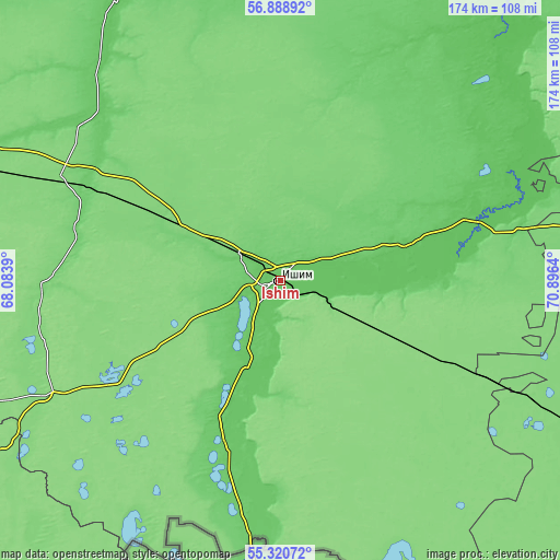
| \ | Map #1 | Map #2 | Topo.Map |
| Scale [m] | 63..94 m | 63..130 m | × |
| Scale [ft] | 207..308 ft | 207..427 ft | × |
| Average | 77.5 m = 254 ft | 78.6 m = 258 ft | × |
| Width | 5.45 km = 3.4 mi | 10.9 km = 6.8 mi | 174.4 km = 108.4 mi |
| Height | 5.45 km = 3.4 mi | 10.9 km = 6.8 mi | 174.3 km = 108.3 mi |
| ↑Max Latitude | 56.137304° | 56.161783° | 56.88892° |
| Latitude at center | 56.11281° | 56.11281° | 56.11281° |
| ↓Min Latitude | 56.0883° | 56.063775° | 55.32072° |
| ← Min Longitude | 69.446205° | 69.402259° | 68.0839° |
| Longitude center | 69.49015° | 69.49015° | 69.49015° |
| →Max Longitude | 69.534095° | 69.578041° | 70.8964° |
Nearby cities:
Cities around Ishim sort by population:
• Golyshmanovo elevation 122 m
75.9 km,  294°
294°
• Nazyvayevsk 123 m
131 km,  117°
117°
• Omutinskiy 99 m
119.2 km, 289°
• Abatskoye 75 m
62.8 km,  71°
71°
• Krutinka 105 m
126 km,  95°
95°
• Vikulovo 67 m
104.2 km,  41°
41°
• Kazanskoye 85 m
54.4 km,  197°
197°
• Aromashevo 76 m
98.2 km,  327°
327°
• Armizonskoye 135 m
114.4 km,  260°
260°
• Sladkovo 133 m
83.9 km,  140°
140°
• Novoseleznëvo 88 m
51.1 km, 200°
• Uspenka 121 m
78.3 km,  348°
348°
Multilingual:
 En español:
Ishim elevación 80 m.
 En France:
Ichim élévation 80 m.


Sources and notes:
- [note 1] Map square and city borders are not equal. Map elevation data is calculated only from area inside that square.
- [src 1] Elevation data from geonames database provided with same terms of usage.
- [src 2] The elevation map of Ishim is generated using elevation data from NASA's 3 arcsec (90m) resolution SRTM data.
- [src 3] Base (background) map © OpenStreetMap contributors tiles are generated by Geofabrik and OpenTopoMap.
Copyright & License:
This Ishim Elevation Map is licensed under CC BY-SA. You may reuse any part from this page, if you give a proper credit by linking to this URL:
 More info on terms of use page.