Kansk elevation
Kansk (Krasnoyarskiy), Russia elevation is 209 meters and Kansk elevation in feet is 686 ft above sea level [src 1]. Kansk is a populated place (feature code) with elevation that is 10 meters (33 ft) bigger than average city elevation in Russia.
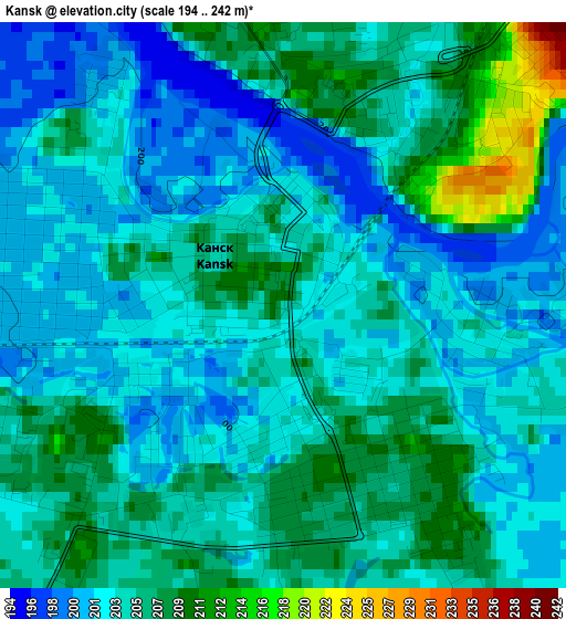
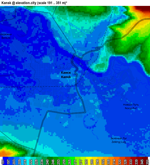
Below is the Elevation map of Kansk, which displays elevation range with different colors. Scale of the first map is from 194 to 242 m (636 to 794 ft) with average elevation of 204.4 meters (=671 ft) [note 1]
These maps also provides idea of topography and contour of this city, they are displayed at different zoom levels. More info about maps, scale and edge coordinates you can find below images.
| \ | Map #1 | Map #2 | Topo.Map |
| Scale [m] | 194..242 m | 191..351 m | × |
| Scale [ft] | 636..794 ft | 627..1152 ft | × |
| Average | 204.4 m = 671 ft | 212 m = 696 ft | × |
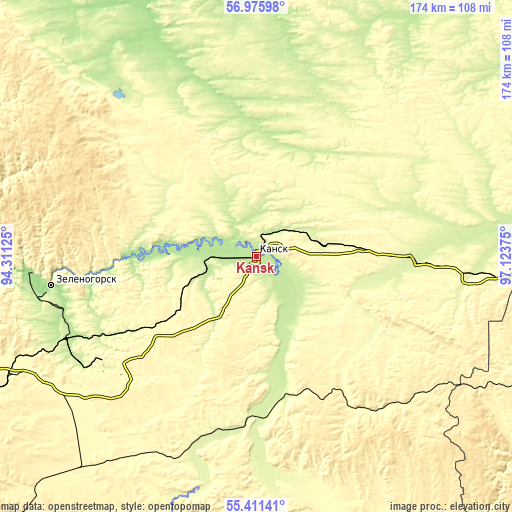
| Width | 5.44 km = 3.4 mi | 10.87 km = 6.8 mi | 174 km = 108.1 mi |
| Height | 5.44 km = 3.4 mi | 10.87 km = 6.8 mi | 173.9 km = 108.1 mi |
| ↑Max Latitude | 56.226108° | 56.25053° | 56.97598° |
| Latitude at center | 56.20167° | 56.20167° | 56.20167° |
| ↓Min Latitude | 56.177217° | 56.152748° | 55.41141° |
| ← Min Longitude | 95.673555° | 95.629609° | 94.31125° |
| Longitude center | 95.7175° | 95.7175° | 95.7175° |
| →Max Longitude | 95.761445° | 95.805391° | 97.12375° |
Nearby cities:
Cities around Kansk sort by population:
• Zelenogorsk elevation 167 m
70 km,  261°
261°
• Borodino 337 m
60.1 km,  236°
236°
• Ilanskiy 282 m
21.8 km,  80°
80°
• Aban 239 m
57.2 km,  21°
21°
• Nizhnyaya Poyma 264 m
92.2 km,  92°
92°
• Nizhniy Ingash 258 m
50.7 km, 90°
• Dzerzhinskoye 181 m
76.5 km,  336°
336°
• Irbeyskoye 249 m
64.7 km,  194°
194°
• Tinskoy 252 m
74.5 km, 94°
• Filimonovo 202 m
15.9 km,  269°
269°
• Ural 259 m
68.3 km, 241°
• Irsha 276 m
64.6 km, 241°
Multilingual:
 En español:
Kansk elevación 209 m.
 En France:
Kansk élévation 209 m.


Sources and notes:
- [note 1] Map square and city borders are not equal. Map elevation data is calculated only from area inside that square.
- [src 1] Elevation data from geonames database provided with same terms of usage.
- [src 2] The elevation map of Kansk is generated using elevation data from NASA's 3 arcsec (90m) resolution SRTM data.
- [src 3] Base (background) map © OpenStreetMap contributors tiles are generated by Geofabrik and OpenTopoMap.
Copyright & License:
This Kansk Elevation Map is licensed under CC BY-SA. You may reuse any part from this page, if you give a proper credit by linking to this URL:
 More info on terms of use page.