Karagayla elevation
Karagayla (Kemerovo Oblast), Russia elevation is 280 meters and Karagayla elevation in feet is 919 ft above sea level [src 1]. Karagayla is a populated place (feature code) with elevation that is 81 meters (266 ft) bigger than average city elevation in Russia.
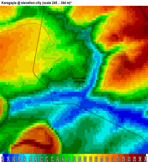
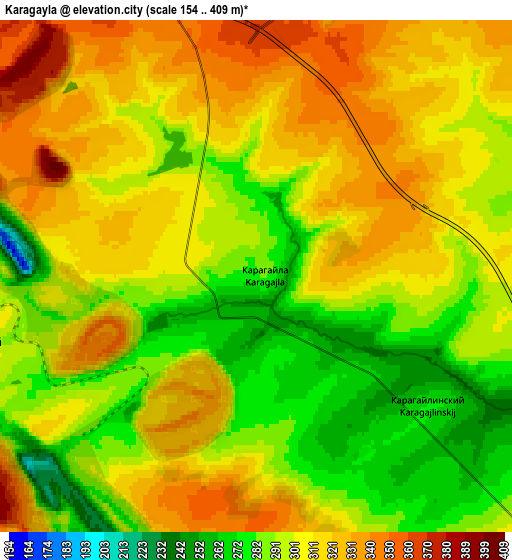
Below is the Elevation map of Karagayla, which displays elevation range with different colors. Scale of the first map is from 245 to 344 m (804 to 1129 ft) with average elevation of 290.1 meters (=952 ft) [note 1]
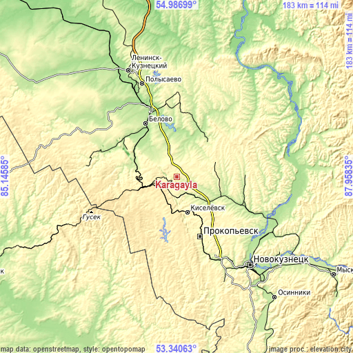
These maps also provides idea of topography and contour of this city, they are displayed at different zoom levels. More info about maps, scale and edge coordinates you can find below images.
| \ | Map #1 | Map #2 | Topo.Map |
| Scale [m] | 245..344 m | 154..409 m | × |
| Scale [ft] | 804..1129 ft | 505..1342 ft | × |
| Average | 290.1 m = 952 ft | 303.8 m = 997 ft | × |
| Width | 5.72 km = 3.6 mi | 11.44 km = 7.1 mi | 183.1 km = 113.8 mi |
| Height | 5.72 km = 3.6 mi | 11.44 km = 7.1 mi | 183 km = 113.7 mi |
| ↑Max Latitude | 54.197716° | 54.223415° | 54.98699° |
| Latitude at center | 54.172° | 54.172° | 54.172° |
| ↓Min Latitude | 54.146268° | 54.120521° | 53.34063° |
| ← Min Longitude | 86.508155° | 86.464209° | 85.14585° |
| Longitude center | 86.5521° | 86.5521° | 86.5521° |
| →Max Longitude | 86.596045° | 86.639991° | 87.95835° |
Nearby cities:
Cities around Karagayla sort by population:
• Prokop’yevsk elevation 321 m
31.5 km,  159°
159°
• Kiselëvsk 320 m
21.5 km, 160°
• Belovo 206 m
31.8 km,  328°
328°
• Gur’yevsk 227 m
42.1 km,  287°
287°
• Bachatskiy 263 m
30.6 km,  295°
295°
• Gramoteino 219 m
42 km,  344°
344°
• Inskoy 220 m
29.6 km,  345°
345°
• Krasnobrodskiy 314 m
6.9 km,  257°
257°
• Trudarmeyskiy 447 m
10.3 km,  244°
244°
• Starobachaty 215 m
23.8 km, 289°
• Staropesterevo 208 m
37.6 km, 345°
• Artyshta 405 m
17.9 km,  251°
251°
Multilingual:
 En español:
Karagayla elevación 280 m.
 En France:
Karagayla élévation 280 m.
 Auf Deutsch:
Karagayla höhe über dem Meeresspiegel ist 280 m.
 На русском:
Карагайлинский, Карагайла высота над уровнем моря 280 м
Sources and notes:
- [note 1] Map square and city borders are not equal. Map elevation data is calculated only from area inside that square.
- [src 1] Elevation data from geonames database provided with same terms of usage.
- [src 2] The elevation map of Karagayla is generated using elevation data from NASA's 3 arcsec (90m) resolution SRTM data.
- [src 3] Base (background) map © OpenStreetMap contributors tiles are generated by Geofabrik and OpenTopoMap.
Copyright & License:
This Karagayla Elevation Map is licensed under CC BY-SA. You may reuse any part from this page, if you give a proper credit by linking to this URL:
 More info on terms of use page.