Kuragino elevation
Kuragino (Krasnoyarskiy), Russia elevation is 283 meters and Kuragino elevation in feet is 928 ft above sea level [src 1]. Kuragino is a populated place (feature code) with elevation that is 84 meters (276 ft) bigger than average city elevation in Russia.
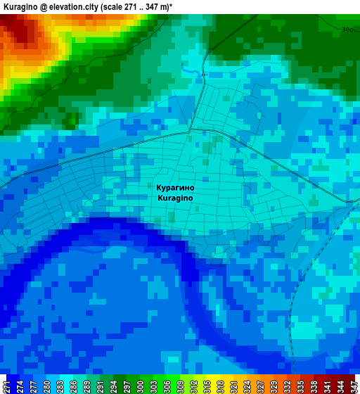
Below is the Elevation map of Kuragino, which displays elevation range with different colors. Scale of the first map is from 271 to 347 m (889 to 1138 ft) with average elevation of 284.7 meters (=934 ft) [note 1]
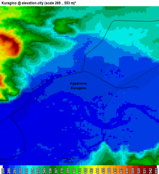
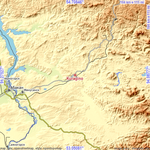
These maps also provides idea of topography and contour of this city, they are displayed at different zoom levels. More info about maps, scale and edge coordinates you can find below images.
| \ | Map #1 | Map #2 | Topo.Map |
| Scale [m] | 271..347 m | 269..553 m | × |
| Scale [ft] | 889..1138 ft | 883..1814 ft | × |
| Average | 284.7 m = 934 ft | 308.9 m = 1013 ft | × |
| Width | 5.76 km = 3.6 mi | 11.52 km = 7.2 mi | 184.3 km = 114.5 mi |
| Height | 5.76 km = 3.6 mi | 11.52 km = 7.2 mi | 184.3 km = 114.5 mi |
| ↑Max Latitude | 53.913742° | 53.939618° | 54.70846° |
| Latitude at center | 53.88785° | 53.88785° | 53.88785° |
| ↓Min Latitude | 53.861942° | 53.836018° | 53.05081° |
| ← Min Longitude | 92.637575° | 92.593629° | 91.27527° |
| Longitude center | 92.68152° | 92.68152° | 92.68152° |
| →Max Longitude | 92.725465° | 92.769411° | 94.08777° |
Nearby cities:
Cities around Kuragino sort by population:
• Abakan elevation 248 m
84.4 km,  256°
256°
• Minusinsk 251 m
68.2 km,  253°
253°
• Shushenskoye 278 m
79.6 km,  218°
218°
• Ust’-Abakan 238 m
84.8 km,  266°
266°
• Yermakovskoye 298 m
70.6 km,  195°
195°
• Karatuzskoye 314 m
33.5 km,  158°
158°
• Idrinskoye 274 m
64.4 km,  326°
326°
• Krasnokamensk 448 m
62.3 km,  37°
37°
• Sayansk 434 m
59.6 km,  299°
299°
• Koshurnikovo 579 m
50.9 km,  52°
52°
• Podsineye 251 m
79.2 km, 251°
• Zelënyy Bor 269 m
76.1 km, 247°
Multilingual:
 En español:
Kuragino elevación 283 m.
 En France:
Kuragino élévation 283 m.
 Auf Deutsch:
Kuragino höhe über dem Meeresspiegel ist 283 m.

Sources and notes:
- [note 1] Map square and city borders are not equal. Map elevation data is calculated only from area inside that square.
- [src 1] Elevation data from geonames database provided with same terms of usage.
- [src 2] The elevation map of Kuragino is generated using elevation data from NASA's 3 arcsec (90m) resolution SRTM data.
- [src 3] Base (background) map © OpenStreetMap contributors tiles are generated by Geofabrik and OpenTopoMap.
Copyright & License:
This Kuragino Elevation Map is licensed under CC BY-SA. You may reuse any part from this page, if you give a proper credit by linking to this URL:
 More info on terms of use page.