Kurtamysh elevation
Kurtamysh (Kurgan Oblast), Russia elevation is 104 meters and Kurtamysh elevation in feet is 341 ft above sea level [src 1]. Kurtamysh is a populated place (feature code) with elevation that is 95 meters (312 ft) smaller than average city elevation in Russia.
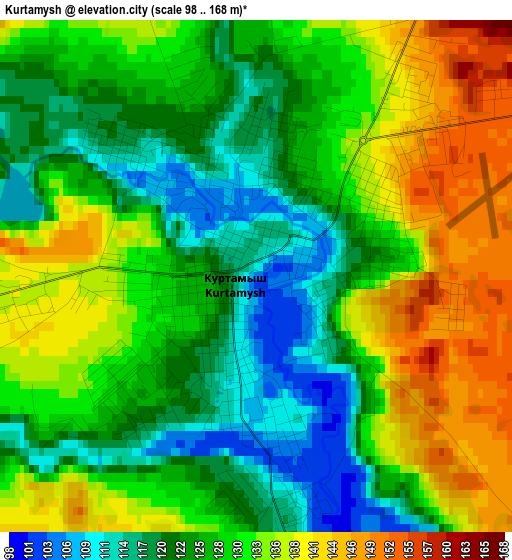
Below is the Elevation map of Kurtamysh, which displays elevation range with different colors. Scale of the first map is from 98 to 168 m (322 to 551 ft) with average elevation of 128.9 meters (=423 ft) [note 1]
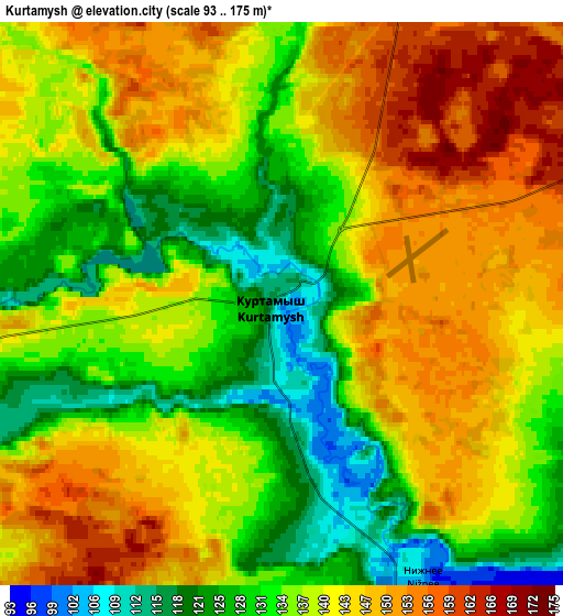
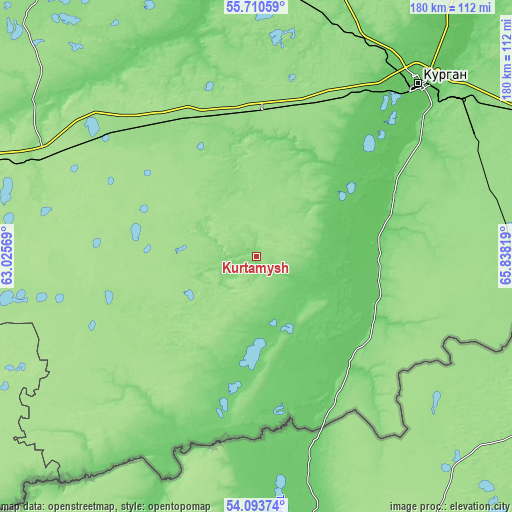
These maps also provides idea of topography and contour of this city, they are displayed at different zoom levels. More info about maps, scale and edge coordinates you can find below images.
| \ | Map #1 | Map #2 | Topo.Map |
| Scale [m] | 98..168 m | 93..175 m | × |
| Scale [ft] | 322..551 ft | 305..574 ft | × |
| Average | 128.9 m = 423 ft | 138.7 m = 455 ft | × |
| Width | 5.62 km = 3.5 mi | 11.24 km = 7 mi | 179.8 km = 111.7 mi |
| Height | 5.62 km = 3.5 mi | 11.24 km = 7 mi | 179.8 km = 111.7 mi |
| ↑Max Latitude | 54.935534° | 54.960773° | 55.71059° |
| Latitude at center | 54.91028° | 54.91028° | 54.91028° |
| ↓Min Latitude | 54.88501° | 54.859724° | 54.09374° |
| ← Min Longitude | 64.387995° | 64.344049° | 63.02569° |
| Longitude center | 64.43194° | 64.43194° | 64.43194° |
| →Max Longitude | 64.475885° | 64.519831° | 65.83819° |
Nearby cities:
Cities around Kurtamysh sort by population:
• Kurgan elevation 76 m
82.9 km,  43°
43°
• Shumikha 174 m
80.4 km,  295°
295°
• Mishkino 151 m
57.8 km,  325°
325°
• Yurgamysh 153 m
51.7 km,  2°
2°
• Ketovo 73 m
75.3 km,  48°
48°
• Lesnikovo 86 m
69.9 km, 53°
• Tselinnoye 139 m
66.7 km,  226°
226°
• Ikovka 135 m
84 km,  22°
22°
• Zverinogolovskoye 98 m
57.5 km,  151°
151°
• Glyadyanskoye 77 m
42 km,  90°
90°
• Vvedenskoye 94 m
75.2 km,  33°
33°
• Prosvet 119 m
84.2 km, 29°
Multilingual:
 En español:
Kurtamysh elevación 104 m.
 En France:
Kourtamych élévation 104 m.
 Auf Deutsch:
Kurtamysch höhe über dem Meeresspiegel ist 104 m.

Sources and notes:
- [note 1] Map square and city borders are not equal. Map elevation data is calculated only from area inside that square.
- [src 1] Elevation data from geonames database provided with same terms of usage.
- [src 2] The elevation map of Kurtamysh is generated using elevation data from NASA's 3 arcsec (90m) resolution SRTM data.
- [src 3] Base (background) map © OpenStreetMap contributors tiles are generated by Geofabrik and OpenTopoMap.
Copyright & License:
This Kurtamysh Elevation Map is licensed under CC BY-SA. You may reuse any part from this page, if you give a proper credit by linking to this URL:
 More info on terms of use page.