Kyzyl elevation
Kyzyl (Republic of Tyva), Russia elevation is 608 meters and Kyzyl elevation in feet is 1995 ft above sea level [src 1]. Kyzyl is a seat of a first-order administrative division (feature code) with elevation that is 409 meters (1342 ft) bigger than average city elevation in Russia.
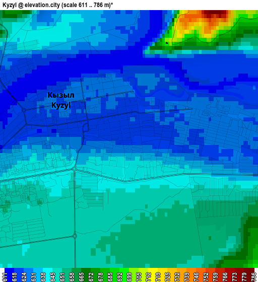
Below is the Elevation map of Kyzyl, which displays elevation range with different colors. Scale of the first map is from 611 to 786 m (2005 to 2579 ft) with average elevation of 639 meters (=2096 ft) [note 1]
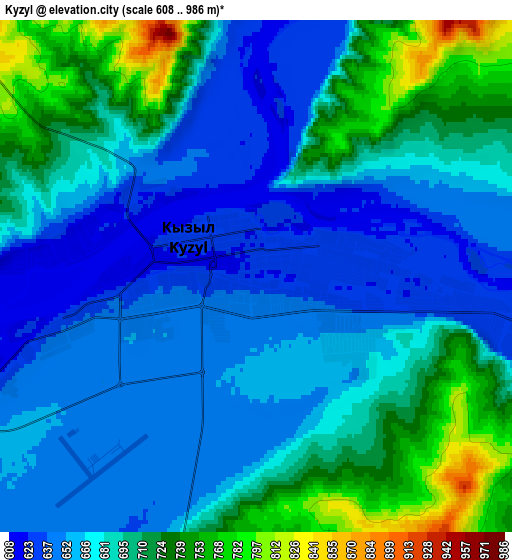
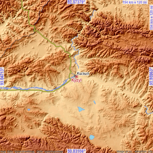
These maps also provides idea of topography and contour of this city, they are displayed at different zoom levels. More info about maps, scale and edge coordinates you can find below images.
| \ | Map #1 | Map #2 | Topo.Map |
| Scale [m] | 611..786 m | 608..986 m | × |
| Scale [ft] | 2005..2579 ft | 1995..3235 ft | × |
| Average | 639 m = 2096 ft | 683.3 m = 2242 ft | × |
| Width | 6.06 km = 3.8 mi | 12.11 km = 7.5 mi | 193.8 km = 120.4 mi |
| Height | 6.06 km = 3.8 mi | 12.11 km = 7.5 mi | 193.8 km = 120.4 mi |
| ↑Max Latitude | 51.738032° | 51.765237° | 52.57379° |
| Latitude at center | 51.71081° | 51.71081° | 51.71081° |
| ↓Min Latitude | 51.683572° | 51.656317° | 50.83104° |
| ← Min Longitude | 94.409435° | 94.365489° | 93.04713° |
| Longitude center | 94.45338° | 94.45338° | 94.45338° |
| →Max Longitude | 94.497325° | 94.541271° | 95.85963° |
Nearby cities:
Cities around Kyzyl sort by population:
• Shagonar elevation 560 m
106.9 km,  259°
259°
• Kaa-Khem 705 m
19.5 km,  98°
98°
• Turan 859 m
60.6 km,  322°
322°
• Saryg-Sep 710 m
80.3 km,  107°
107°
• Khovu-Aksy 1037 m
82.2 km,  218°
218°
• Sukpak 694 m
13.3 km, 111°
• Samagaltay 1252 m
129.1 km,  162°
162°
• Balgazyn 875 m
94.5 km,  146°
146°
• Bay-Khaak 888 m
61.1 km,  179°
179°
• Erzin 1102 m
168.8 km, 162°
• Toora-Khem 909 m
141.3 km,  53°
53°
• Tanzybey 349 m
188.3 km,  327°
327°
Multilingual:
 En español:
Kyzyl elevación 608 m.
 En France:
Kyzyl élévation 608 m.


Sources and notes:
- [note 1] Map square and city borders are not equal. Map elevation data is calculated only from area inside that square.
- [src 1] Elevation data from geonames database provided with same terms of usage.
- [src 2] The elevation map of Kyzyl is generated using elevation data from NASA's 3 arcsec (90m) resolution SRTM data.
- [src 3] Base (background) map © OpenStreetMap contributors tiles are generated by Geofabrik and OpenTopoMap.
Copyright & License:
This Kyzyl Elevation Map is licensed under CC BY-SA. You may reuse any part from this page, if you give a proper credit by linking to this URL:
 More info on terms of use page.