Mel’nikovo elevation
Mel’nikovo (Tomsk Oblast), Russia elevation is 88 meters and Mel’nikovo elevation in feet is 289 ft above sea level [src 1]. Mel’nikovo is a populated place (feature code) with elevation that is 111 meters (364 ft) smaller than average city elevation in Russia.
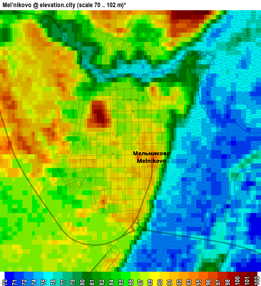
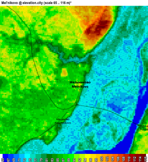
Below is the Elevation map of Mel’nikovo, which displays elevation range with different colors. Scale of the first map is from 70 to 102 m (230 to 335 ft) with average elevation of 83.1 meters (=273 ft) [note 1]
These maps also provides idea of topography and contour of this city, they are displayed at different zoom levels. More info about maps, scale and edge coordinates you can find below images.
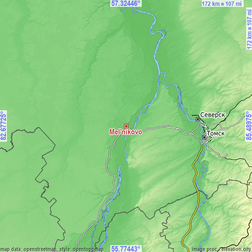
| \ | Map #1 | Map #2 | Topo.Map |
| Scale [m] | 70..102 m | 65..116 m | × |
| Scale [ft] | 230..335 ft | 213..381 ft | × |
| Average | 83.1 m = 273 ft | 83.2 m = 273 ft | × |
| Width | 5.39 km = 3.3 mi | 10.77 km = 6.7 mi | 172.3 km = 107.1 mi |
| Height | 5.39 km = 3.3 mi | 10.77 km = 6.7 mi | 172.3 km = 107.1 mi |
| ↑Max Latitude | 56.581591° | 56.605786° | 57.32446° |
| Latitude at center | 56.55738° | 56.55738° | 56.55738° |
| ↓Min Latitude | 56.533154° | 56.508912° | 55.77443° |
| ← Min Longitude | 84.039555° | 83.995609° | 82.67725° |
| Longitude center | 84.0835° | 84.0835° | 84.0835° |
| →Max Longitude | 84.127445° | 84.171391° | 85.48975° |
Nearby cities:
Cities around Mel’nikovo sort by population:
• Tomsk elevation 117 m
55 km,  96°
96°
• Seversk 98 m
49.4 km,  84°
84°
• Bolotnoye 203 m
100.4 km,  168°
168°
• Aleksandrovskoye 149 m
82.5 km, 75°
• Kozhevnikovo 90 m
33.9 km,  191°
191°
• Timiryazevskoye 98 m
49.3 km, 98°
• Krivosheino 102 m
87.9 km,  353°
353°
• Samus’ 83 m
43.3 km,  61°
61°
• Moryakovskiy Zaton 96 m
37.9 km,  66°
66°
• Bogashevo 187 m
68.5 km,  107°
107°
• Krasnyy Yar 69 m
69 km,  23°
23°
• Kaltay 112 m
57.9 km,  122°
122°
Multilingual:
 En español:
Mel’nikovo elevación 88 m.
 En France:
Mel’nikovo élévation 88 m.
 Auf Deutsch:
Mel’nikovo höhe über dem Meeresspiegel ist 88 m.

Sources and notes:
- [note 1] Map square and city borders are not equal. Map elevation data is calculated only from area inside that square.
- [src 1] Elevation data from geonames database provided with same terms of usage.
- [src 2] The elevation map of Mel’nikovo is generated using elevation data from NASA's 3 arcsec (90m) resolution SRTM data.
- [src 3] Base (background) map © OpenStreetMap contributors tiles are generated by Geofabrik and OpenTopoMap.
Copyright & License:
This Mel’nikovo Elevation Map is licensed under CC BY-SA. You may reuse any part from this page, if you give a proper credit by linking to this URL:
 More info on terms of use page.