Nadym elevation
Nadym (Yamalo-Nenets), Russia elevation is 7 meters and Nadym elevation in feet is 23 ft above sea level [src 1]. Nadym is a populated place (feature code) with elevation that is 192 meters (630 ft) smaller than average city elevation in Russia.
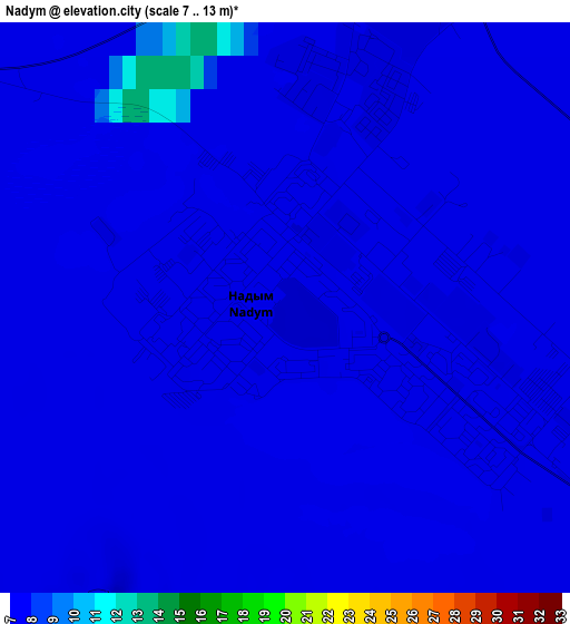
Below is the Elevation map of Nadym, which displays elevation range with different colors. Scale of the first map is from 7 to 13 m (23 to 43 ft) with average elevation of 7.1 meters (=23 ft) [note 1]
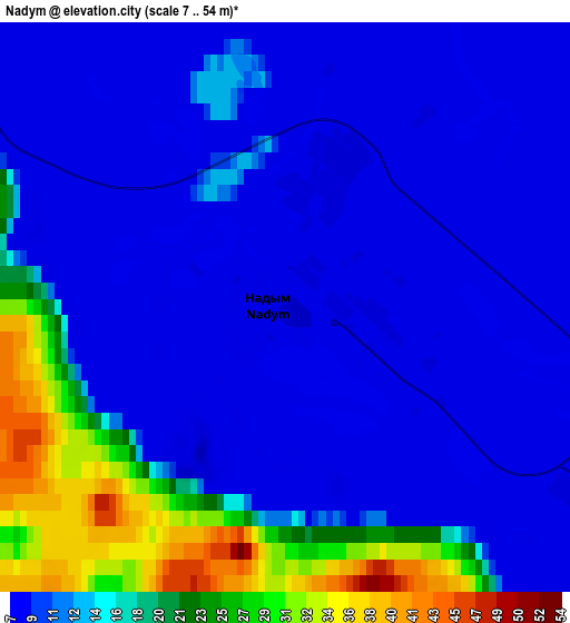
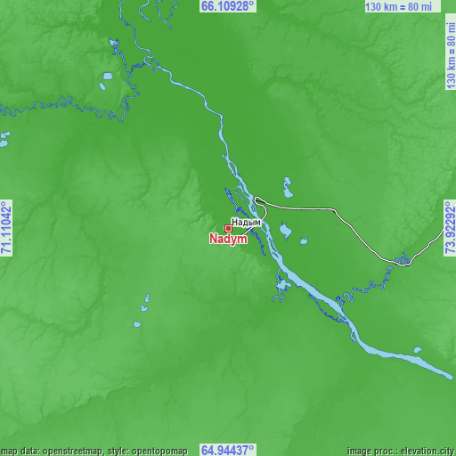
These maps also provides idea of topography and contour of this city, they are displayed at different zoom levels. More info about maps, scale and edge coordinates you can find below images.
| \ | Map #1 | Map #2 | Topo.Map |
| Scale [m] | 7..13 m | 7..54 m | × |
| Scale [ft] | 23..43 ft | 23..177 ft | × |
| Average | 7.1 m = 23 ft | 12.4 m = 41 ft | × |
| Width | 4.05 km = 2.5 mi | 8.09 km = 5 mi | 129.5 km = 80.5 mi |
| Height | 4.05 km = 2.5 mi | 8.09 km = 5 mi | 129.5 km = 80.5 mi |
| ↑Max Latitude | 65.551524° | 65.569706° | 66.10928° |
| Latitude at center | 65.53333° | 65.53333° | 65.53333° |
| ↓Min Latitude | 65.515123° | 65.496903° | 64.94437° |
| ← Min Longitude | 72.472725° | 72.428779° | 71.11042° |
| Longitude center | 72.51667° | 72.51667° | 72.51667° |
| →Max Longitude | 72.560615° | 72.604561° | 73.92292° |
Nearby cities:
Cities around Nadym sort by population:
• Noyabrsk elevation 110 m
295.6 km,  151°
151°
• Kogalym 93 m
375.8 km,  165°
165°
• Muravlenko 120 m
216.1 km, 153°
• Lyantor 57 m
435.5 km,  182°
182°
• Nizhnesortymskiy 73 m
346 km,  186°
186°
• Pangody 37 m
96.8 km,  68°
68°
• Yar-Sale 12 m
166.2 km,  333°
333°
• Staryy Nadym 16 m
11.6 km,  41°
41°
• Nyda 4 m
122.7 km,  8°
8°
• Mys-Kamennyy 1 m
328.7 km, 8°
• Russkinskiye 47 m
379.5 km, 171°
Multilingual:
 En español:
Nadym elevación 7 m.
 En France:
Nadym élévation 7 m.


Sources and notes:
- [note 1] Map square and city borders are not equal. Map elevation data is calculated only from area inside that square.
- [src 1] Elevation data from geonames database provided with same terms of usage.
- [src 2] The elevation map of Nadym is generated using GMTED2010 database with 7.5 arcsec (225m) resolution.
- [src 3] Base (background) map © OpenStreetMap contributors tiles are generated by Geofabrik and OpenTopoMap.
Copyright & License:
This Nadym Elevation Map is licensed under CC BY-SA. You may reuse any part from this page, if you give a proper credit by linking to this URL:
 More info on terms of use page.