Novokuznetsk elevation
Novokuznetsk (Kemerovo Oblast), Russia elevation is 208 meters and Novokuznetsk elevation in feet is 682 ft above sea level [src 1]. Novokuznetsk is a populated place (feature code) with elevation that is 9 meters (30 ft) bigger than average city elevation in Russia.
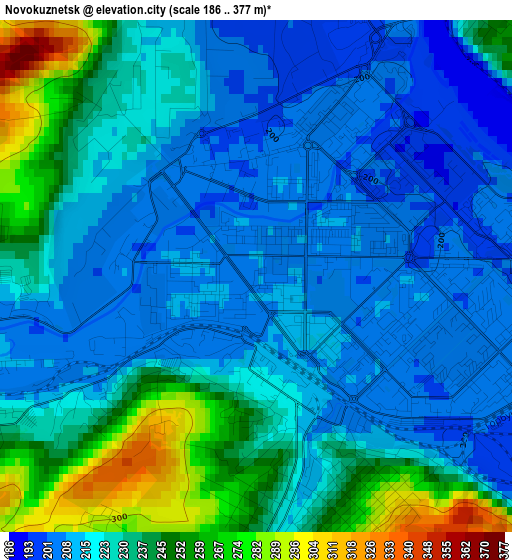
Below is the Elevation map of Novokuznetsk, which displays elevation range with different colors. Scale of the first map is from 186 to 377 m (610 to 1237 ft) with average elevation of 226.1 meters (=742 ft) [note 1]
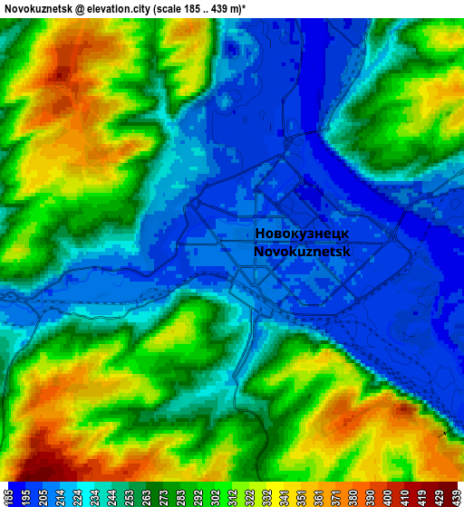
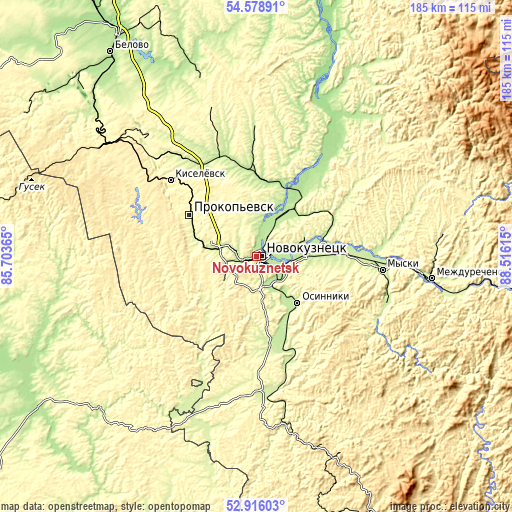
These maps also provides idea of topography and contour of this city, they are displayed at different zoom levels. More info about maps, scale and edge coordinates you can find below images.
| \ | Map #1 | Map #2 | Topo.Map |
| Scale [m] | 186..377 m | 185..439 m | × |
| Scale [ft] | 610..1237 ft | 607..1440 ft | × |
| Average | 226.1 m = 742 ft | 266.8 m = 875 ft | × |
| Width | 5.78 km = 3.6 mi | 11.56 km = 7.2 mi | 184.9 km = 114.9 mi |
| Height | 5.78 km = 3.6 mi | 11.56 km = 7.2 mi | 184.9 km = 114.9 mi |
| ↑Max Latitude | 53.781674° | 53.807631° | 54.57891° |
| Latitude at center | 53.7557° | 53.7557° | 53.7557° |
| ↓Min Latitude | 53.72971° | 53.703704° | 52.91603° |
| ← Min Longitude | 87.065955° | 87.022009° | 85.70365° |
| Longitude center | 87.1099° | 87.1099° | 87.1099° |
| →Max Longitude | 87.153845° | 87.197791° | 88.51615° |
Nearby cities:
Cities around Novokuznetsk sort by population:
• Prokop’yevsk elevation 321 m
30.6 km,  303°
303°
• Kiselëvsk 320 m
39.2 km,  311°
311°
• Osinniki 291 m
22 km,  131°
131°
• Myski 239 m
45.8 km,  96°
96°
• Kaltan 215 m
26.2 km,  159°
159°
• Abagur 202 m
9.8 km,  106°
106°
• Tayzhina 337 m
23.6 km, 114°
• Listvyagi 298 m
13.6 km,  230°
230°
• Pritomskiy 229 m
32.8 km,  86°
86°
• Chistogorskiy 198 m
31.1 km,  35°
35°
• Kuzedeyevo 232 m
47.6 km,  172°
172°
• Sosnovka 217 m
10.2 km, 163°
Multilingual:
 En español:
Novokuznetsk elevación 208 m.
 En France:
Novokouznetsk élévation 208 m.
 Auf Deutsch:
Nowokusnezk höhe über dem Meeresspiegel ist 208 m.

Sources and notes:
- [note 1] Map square and city borders are not equal. Map elevation data is calculated only from area inside that square.
- [src 1] Elevation data from geonames database provided with same terms of usage.
- [src 2] The elevation map of Novokuznetsk is generated using elevation data from NASA's 3 arcsec (90m) resolution SRTM data.
- [src 3] Base (background) map © OpenStreetMap contributors tiles are generated by Geofabrik and OpenTopoMap.
Copyright & License:
This Novokuznetsk Elevation Map is licensed under CC BY-SA. You may reuse any part from this page, if you give a proper credit by linking to this URL:
 More info on terms of use page.