Polunochnoye elevation
Polunochnoye (Sverdlovsk), Russia elevation is 182 meters and Polunochnoye elevation in feet is 597 ft above sea level [src 1]. Polunochnoye is a populated place (feature code) with elevation that is 17 meters (56 ft) smaller than average city elevation in Russia.
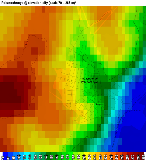
Below is the Elevation map of Polunochnoye, which displays elevation range with different colors. Scale of the first map is from 79 to 288 m (259 to 945 ft) with average elevation of 198.1 meters (=650 ft) [note 1]
These maps also provides idea of topography and contour of this city, they are displayed at different zoom levels. More info about maps, scale and edge coordinates you can find below images.
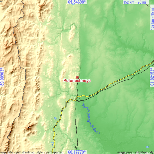
| \ | Map #1 | Topo.Map |
| Scale [m] | 79..288 m | × |
| Scale [ft] | 259..945 ft | × |
| Average | 198.1 m = 650 ft | × |
| Width | 4.76 km = 3 mi | 152.2 km = 94.6 mi |
| Height | 4.76 km = 3 mi | 152.2 km = 94.6 mi |
| ↑Max Latitude | 60.891105° | 61.54698° |
| Latitude at center | 60.86972° | 60.86972° |
| ↓Min Latitude | 60.84832° | 60.17779° |
| ← Min Longitude | 60.371335° | 59.00903° |
| Longitude center | 60.41528° | 60.41528° |
| →Max Longitude | 60.459225° | 61.82153° |
Nearby cities:
Cities around Polunochnoye sort by population:
• Krasnotur’insk elevation 217 m
123.2 km,  185°
185°
• Severoural’sk 173 m
83.6 km,  197°
197°
• Karpinsk 227 m
124.4 km, 190°
• Ivdel’ 82 m
19.9 km,  179°
179°
• Volchansk 241 m
105.2 km, 190°
• Cherëmukhovo 191 m
62.5 km, 202°
• Pionerskiy 97 m
137 km,  74°
74°
• Rudnichnyy 179 m
130.1 km, 183°
• Pelym 87 m
86.9 km,  79°
79°
• Malinovskiy 94 m
135.5 km, 74°
• Tretiy Severnyy 204 m
77.6 km, 198°
• Ous 91 m
59.8 km,  86°
86°
Multilingual:
 En español:
Polunochnoye elevación 182 m.
 En France:
Polunochnoye élévation 182 m.
 Auf Deutsch:
Polunochnoye höhe über dem Meeresspiegel ist 182 m.

Sources and notes:
- [note 1] Map square and city borders are not equal. Map elevation data is calculated only from area inside that square.
- [src 1] Elevation data from geonames database provided with same terms of usage.
- [src 2] The elevation map of Polunochnoye is generated using GMTED2010 database with 7.5 arcsec (225m) resolution.
- [src 3] Base (background) map © OpenStreetMap contributors tiles are generated by Geofabrik and OpenTopoMap.
Copyright & License:
This Polunochnoye Elevation Map is licensed under CC BY-SA. You may reuse any part from this page, if you give a proper credit by linking to this URL:
 More info on terms of use page.