Shebalino elevation
Shebalino (Altai), Russia elevation is 861 meters and Shebalino elevation in feet is 2825 ft above sea level [src 1]. Shebalino is a populated place (feature code) with elevation that is 662 meters (2172 ft) bigger than average city elevation in Russia.
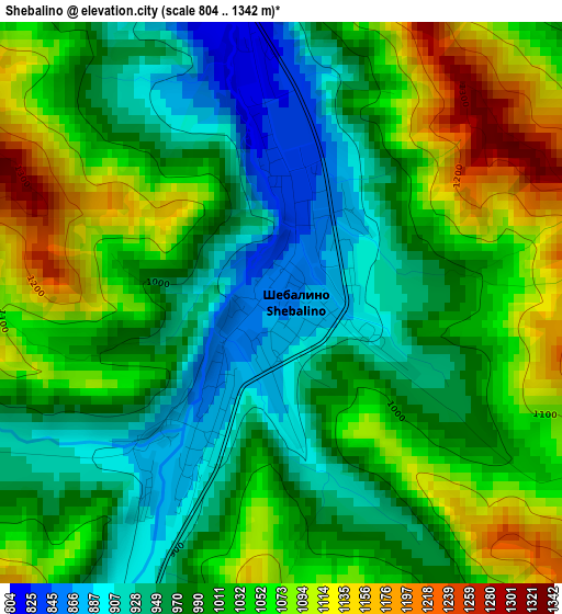
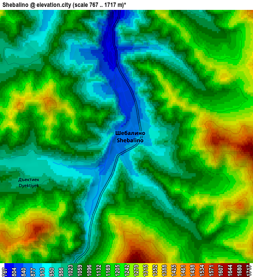
Below is the Elevation map of Shebalino, which displays elevation range with different colors. Scale of the first map is from 804 to 1342 m (2638 to 4403 ft) with average elevation of 1011.1 meters (=3317 ft) [note 1]
These maps also provides idea of topography and contour of this city, they are displayed at different zoom levels. More info about maps, scale and edge coordinates you can find below images.
| \ | Map #1 | Map #2 | Topo.Map |
| Scale [m] | 804..1342 m | 767..1717 m | × |
| Scale [ft] | 2638..4403 ft | 2516..5633 ft | × |
| Average | 1011.1 m = 3317 ft | 1123.9 m = 3687 ft | × |
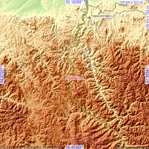
| Width | 6.11 km = 3.8 mi | 12.22 km = 7.6 mi | 195.6 km = 121.5 mi |
| Height | 6.11 km = 3.8 mi | 12.22 km = 7.6 mi | 195.5 km = 121.5 mi |
| ↑Max Latitude | 51.319143° | 51.3466° | 52.16268° |
| Latitude at center | 51.29167° | 51.29167° | 51.29167° |
| ↓Min Latitude | 51.26418° | 51.236674° | 50.40382° |
| ← Min Longitude | 85.633275° | 85.589329° | 84.27097° |
| Longitude center | 85.67722° | 85.67722° | 85.67722° |
| →Max Longitude | 85.721165° | 85.765111° | 87.08347° |
Nearby cities:
Cities around Shebalino sort by population:
• Gorno-Altaysk elevation 285 m
76.2 km,  12°
12°
• Mayma 252 m
82.1 km, 11°
• Altayskoye 288 m
77.3 km,  342°
342°
• Onguday 839 m
68.7 km,  151°
151°
• Ust’-Kan 1042 m
75.7 km,  237°
237°
• Chemal 428 m
26.4 km,  59°
59°
• Aya 270 m
73.2 km, 6°
• Cherga 476 m
31.8 km,  345°
345°
• Manzherok 282 m
60.3 km, 6°
• Elekmonar 389 m
28.5 km,  49°
49°
• Souzga 285 m
67.3 km, 10°
• Topol’noye 525 m
86.5 km,  286°
286°
Multilingual:
 En español:
Shebalino elevación 861 m.
 En France:
Shebalino élévation 861 m.
 Auf Deutsch:
Shebalino höhe über dem Meeresspiegel ist 861 m.

Sources and notes:
- [note 1] Map square and city borders are not equal. Map elevation data is calculated only from area inside that square.
- [src 1] Elevation data from geonames database provided with same terms of usage.
- [src 2] The elevation map of Shebalino is generated using elevation data from NASA's 3 arcsec (90m) resolution SRTM data.
- [src 3] Base (background) map © OpenStreetMap contributors tiles are generated by Geofabrik and OpenTopoMap.
Copyright & License:
This Shebalino Elevation Map is licensed under CC BY-SA. You may reuse any part from this page, if you give a proper credit by linking to this URL:
 More info on terms of use page.