Slavgorodskoye elevation
Slavgorodskoye (Altai Krai), Russia elevation is 112 meters and Slavgorodskoye elevation in feet is 367 ft above sea level [src 1]. Slavgorodskoye is a populated place (feature code) with elevation that is 87 meters (285 ft) smaller than average city elevation in Russia.
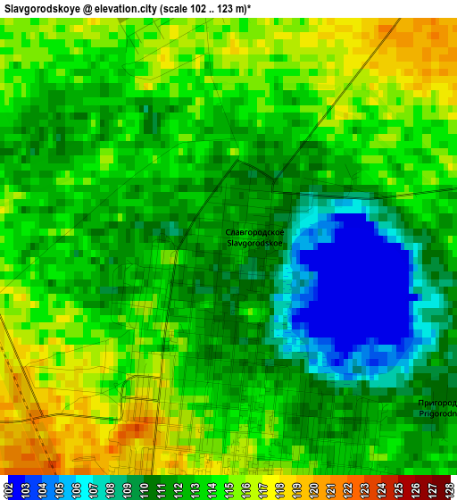
Below is the Elevation map of Slavgorodskoye, which displays elevation range with different colors. Scale of the first map is from 102 to 123 m (335 to 404 ft) with average elevation of 112.6 meters (=369 ft) [note 1]
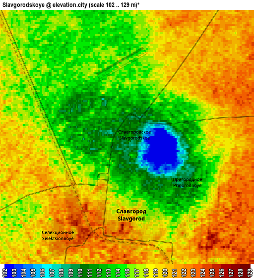
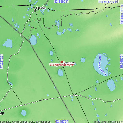
These maps also provides idea of topography and contour of this city, they are displayed at different zoom levels. More info about maps, scale and edge coordinates you can find below images.
| \ | Map #1 | Map #2 | Topo.Map |
| Scale [m] | 102..123 m | 102..129 m | × |
| Scale [ft] | 335..404 ft | 335..423 ft | × |
| Average | 112.6 m = 369 ft | 117.2 m = 385 ft | × |
| Width | 5.88 km = 3.7 mi | 11.76 km = 7.3 mi | 188.1 km = 116.9 mi |
| Height | 5.88 km = 3.7 mi | 11.76 km = 7.3 mi | 188.1 km = 116.9 mi |
| ↑Max Latitude | 53.047826° | 53.074235° | 53.85901° |
| Latitude at center | 53.0214° | 53.0214° | 53.0214° |
| ↓Min Latitude | 52.994958° | 52.9685° | 52.1672° |
| ← Min Longitude | 78.599555° | 78.555609° | 77.23725° |
| Longitude center | 78.6435° | 78.6435° | 78.6435° |
| →Max Longitude | 78.687445° | 78.731391° | 80.04975° |
Nearby cities:
Cities around Slavgorodskoye sort by population:
• Slavgorod elevation 116 m
2.6 km,  177°
177°
• Karasuk 114 m
89.1 km,  333°
333°
• Yarovoye 102 m
11.3 km,  202°
202°
• Kulunda 136 m
54.4 km,  158°
158°
• Blagoveshchenka 109 m
84.6 km,  104°
104°
• Burla 111 m
40.8 km, 329°
• Tabuny 128 m
28.9 km, 160°
• Podsosnovo 118 m
43.1 km,  25°
25°
• Gal’bshtadt 140 m
32.2 km,  44°
44°
• Kusak 136 m
29.7 km, 40°
• Grishkovka 122 m
15.9 km, 26°
• Ust’yanka 118 m
48.4 km,  7°
7°
Multilingual:
 En español:
Slavgorodskoye elevación 112 m.
 En France:
Slavgorodskoye élévation 112 m.
 Auf Deutsch:
Slavgorodskoye höhe über dem Meeresspiegel ist 112 m.

Sources and notes:
- [note 1] Map square and city borders are not equal. Map elevation data is calculated only from area inside that square.
- [src 1] Elevation data from geonames database provided with same terms of usage.
- [src 2] The elevation map of Slavgorodskoye is generated using elevation data from NASA's 3 arcsec (90m) resolution SRTM data.
- [src 3] Base (background) map © OpenStreetMap contributors tiles are generated by Geofabrik and OpenTopoMap.
Copyright & License:
This Slavgorodskoye Elevation Map is licensed under CC BY-SA. You may reuse any part from this page, if you give a proper credit by linking to this URL:
 More info on terms of use page.