Staroaleyskoye elevation
Staroaleyskoye (Altai Krai), Russia elevation is 298 meters and Staroaleyskoye elevation in feet is 978 ft above sea level [src 1]. Staroaleyskoye is a populated place (feature code) with elevation that is 99 meters (325 ft) bigger than average city elevation in Russia.
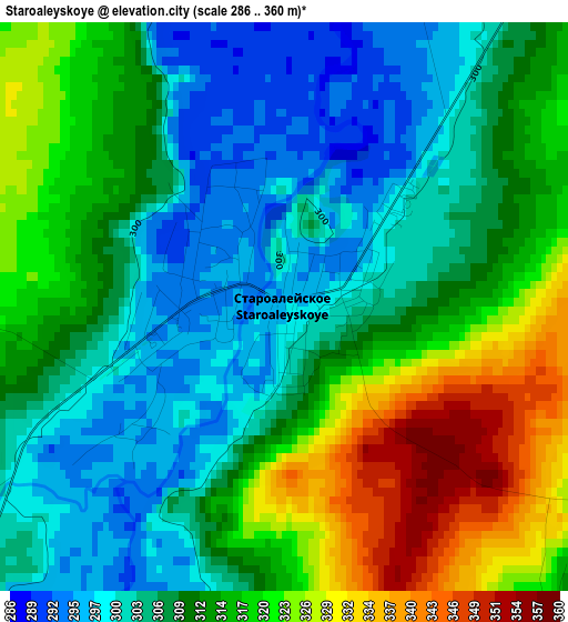
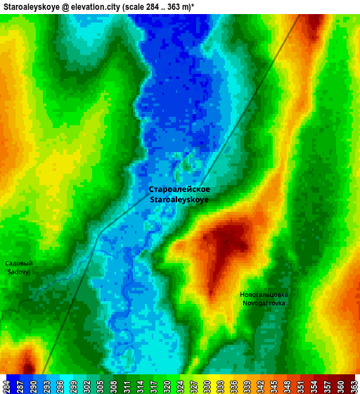
Below is the Elevation map of Staroaleyskoye, which displays elevation range with different colors. Scale of the first map is from 286 to 360 m (938 to 1181 ft) with average elevation of 311.3 meters (=1021 ft) [note 1]
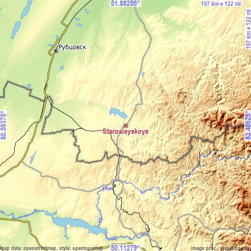
These maps also provides idea of topography and contour of this city, they are displayed at different zoom levels. More info about maps, scale and edge coordinates you can find below images.
| \ | Map #1 | Map #2 | Topo.Map |
| Scale [m] | 286..360 m | 284..363 m | × |
| Scale [ft] | 938..1181 ft | 932..1191 ft | × |
| Average | 311.3 m = 1021 ft | 315.4 m = 1035 ft | × |
| Width | 6.15 km = 3.8 mi | 12.3 km = 7.6 mi | 196.8 km = 122.3 mi |
| Height | 6.15 km = 3.8 mi | 12.3 km = 7.6 mi | 196.8 km = 122.3 mi |
| ↑Max Latitude | 51.033754° | 51.061381° | 51.88255° |
| Latitude at center | 51.00611° | 51.00611° | 51.00611° |
| ↓Min Latitude | 50.97845° | 50.950773° | 50.11279° |
| ← Min Longitude | 81.956055° | 81.912109° | 80.59375° |
| Longitude center | 82° | 82° | 82° |
| →Max Longitude | 82.043945° | 82.087891° | 83.40625° |
Nearby cities:
Cities around Staroaleyskoye sort by population:
• Rubtsovsk elevation 220 m
79.1 km,  315°
315°
• Gornyak 274 m
37.4 km,  267°
267°
• Pospelikha 188 m
106.2 km,  351°
351°
• Zmeinogorsk 398 m
21.7 km,  38°
38°
• Shipunovo 182 m
129 km,  6°
6°
• Volchikha 206 m
159.6 km,  314°
314°
• Ust’-Kalmanka 167 m
153.3 km, 36°
• Krasnoshchekovo 242 m
89.6 km,  34°
34°
• Veseloyarsk 231 m
69.7 km,  296°
296°
• Uglovskoye 189 m
131.7 km,  287°
287°
• Novichikha 236 m
139.7 km,  342°
342°
• Charyshskoye 425 m
117.1 km,  68°
68°
Multilingual:
 En español:
Staroaleyskoye elevación 298 m.
 En France:
Staroaleyskoye élévation 298 m.
 Auf Deutsch:
Staroaleyskoye höhe über dem Meeresspiegel ist 298 m.

Sources and notes:
- [note 1] Map square and city borders are not equal. Map elevation data is calculated only from area inside that square.
- [src 1] Elevation data from geonames database provided with same terms of usage.
- [src 2] The elevation map of Staroaleyskoye is generated using elevation data from NASA's 3 arcsec (90m) resolution SRTM data.
- [src 3] Base (background) map © OpenStreetMap contributors tiles are generated by Geofabrik and OpenTopoMap.
Copyright & License:
This Staroaleyskoye Elevation Map is licensed under CC BY-SA. You may reuse any part from this page, if you give a proper credit by linking to this URL:
 More info on terms of use page.