Talitsa elevation
Talitsa (Sverdlovsk), Russia elevation is 88 meters and Talitsa elevation in feet is 289 ft above sea level [src 1]. Talitsa is a populated place (feature code) with elevation that is 111 meters (364 ft) smaller than average city elevation in Russia.
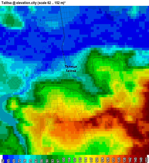
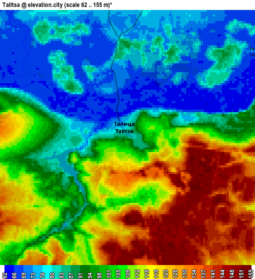
Below is the Elevation map of Talitsa, which displays elevation range with different colors. Scale of the first map is from 62 to 152 m (203 to 499 ft) with average elevation of 93.9 meters (=308 ft) [note 1]
These maps also provides idea of topography and contour of this city, they are displayed at different zoom levels. More info about maps, scale and edge coordinates you can find below images.
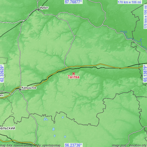
| \ | Map #1 | Map #2 | Topo.Map |
| Scale [m] | 62..152 m | 62..155 m | × |
| Scale [ft] | 203..499 ft | 203..509 ft | × |
| Average | 93.9 m = 308 ft | 99.6 m = 327 ft | × |
| Width | 5.32 km = 3.3 mi | 10.64 km = 6.6 mi | 170.3 km = 105.8 mi |
| Height | 5.32 km = 3.3 mi | 10.64 km = 6.6 mi | 170.3 km = 105.8 mi |
| ↑Max Latitude | 57.03487° | 57.058774° | 57.76877° |
| Latitude at center | 57.01095° | 57.01095° | 57.01095° |
| ↓Min Latitude | 56.987015° | 56.963065° | 56.23736° |
| ← Min Longitude | 63.688595° | 63.644649° | 62.32629° |
| Longitude center | 63.73254° | 63.73254° | 63.73254° |
| →Max Longitude | 63.776485° | 63.820431° | 65.13879° |
Nearby cities:
Cities around Talitsa sort by population:
• Kamyshlov elevation 92 m
64.7 km,  253°
253°
• Troitskiy 78 m
5.6 km,  9°
9°
• Pyshma 88 m
29.9 km,  257°
257°
• Yelanskiy 114 m
77 km, 255°
• Shatrovo 114 m
77.4 km,  134°
134°
• Tugulym 82 m
55.3 km,  84°
84°
• Baykalovo 88 m
43.1 km,  2°
2°
• Yushala 112 m
32.7 km, 77°
• Butka 115 m
32.8 km,  174°
174°
• Lugovskoy 71 m
48.6 km,  96°
96°
• Obukhovskoye 90 m
70.8 km, 253°
• Yertarskiy 82 m
42.3 km, 125°
Multilingual:
 En español:
Talitsa elevación 88 m.
 En France:
Talitsa élévation 88 m.


Sources and notes:
- [note 1] Map square and city borders are not equal. Map elevation data is calculated only from area inside that square.
- [src 1] Elevation data from geonames database provided with same terms of usage.
- [src 2] The elevation map of Talitsa is generated using elevation data from NASA's 3 arcsec (90m) resolution SRTM data.
- [src 3] Base (background) map © OpenStreetMap contributors tiles are generated by Geofabrik and OpenTopoMap.
Copyright & License:
This Talitsa Elevation Map is licensed under CC BY-SA. You may reuse any part from this page, if you give a proper credit by linking to this URL:
 More info on terms of use page.