Tashtagol elevation
Tashtagol (Kemerovo Oblast), Russia elevation is 478 meters and Tashtagol elevation in feet is 1568 ft above sea level [src 1]. Tashtagol is a populated place (feature code) with elevation that is 279 meters (915 ft) bigger than average city elevation in Russia.
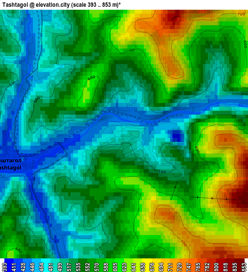
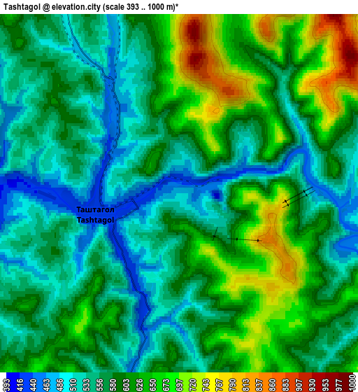
Below is the Elevation map of Tashtagol, which displays elevation range with different colors. Scale of the first map is from 393 to 853 m (1289 to 2799 ft) with average elevation of 553.8 meters (=1817 ft) [note 1]
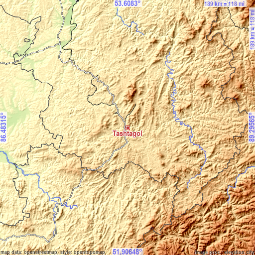
These maps also provides idea of topography and contour of this city, they are displayed at different zoom levels. More info about maps, scale and edge coordinates you can find below images.
| \ | Map #1 | Map #2 | Topo.Map |
| Scale [m] | 393..853 m | 393..1000 m | × |
| Scale [ft] | 1289..2799 ft | 1289..3281 ft | × |
| Average | 553.8 m = 1817 ft | 586.6 m = 1925 ft | × |
| Width | 5.91 km = 3.7 mi | 11.83 km = 7.4 mi | 189.2 km = 117.6 mi |
| Height | 5.91 km = 3.7 mi | 11.83 km = 7.4 mi | 189.2 km = 117.6 mi |
| ↑Max Latitude | 52.792282° | 52.818848° | 53.6083° |
| Latitude at center | 52.7657° | 52.7657° | 52.7657° |
| ↓Min Latitude | 52.739102° | 52.712487° | 51.90648° |
| ← Min Longitude | 87.845455° | 87.801509° | 86.48315° |
| Longitude center | 87.8894° | 87.8894° | 87.8894° |
| →Max Longitude | 87.933345° | 87.977291° | 89.29565° |
Nearby cities:
Cities around Tashtagol sort by population:
• Mezhdurechensk elevation 241 m
103.9 km,  6°
6°
• Osinniki 291 m
101.7 km,  339°
339°
• Kaltan 215 m
95.7 km,  333°
333°
• Sheregesh 603 m
18.5 km,  20°
20°
• Mundybash 288 m
63.4 km,  321°
321°
• Turochak 329 m
76.7 km,  222°
222°
• Tayzhina 337 m
104.8 km, 343°
• Kaz 350 m
42.1 km,  292°
292°
• Temirtau 466 m
50.6 km, 324°
• Kuzedeyevo 232 m
77.8 km, 323°
• Solton 248 m
95.2 km,  275°
275°
• Spassk 443 m
9.3 km,  257°
257°
Multilingual:
 En español:
Tashtagol elevación 478 m.
 En France:
Tashtagol élévation 478 m.
 Auf Deutsch:
Tashtagol höhe über dem Meeresspiegel ist 478 m.

Sources and notes:
- [note 1] Map square and city borders are not equal. Map elevation data is calculated only from area inside that square.
- [src 1] Elevation data from geonames database provided with same terms of usage.
- [src 2] The elevation map of Tashtagol is generated using elevation data from NASA's 3 arcsec (90m) resolution SRTM data.
- [src 3] Base (background) map © OpenStreetMap contributors tiles are generated by Geofabrik and OpenTopoMap.
Copyright & License:
This Tashtagol Elevation Map is licensed under CC BY-SA. You may reuse any part from this page, if you give a proper credit by linking to this URL:
 More info on terms of use page.