Troitsk elevation
Troitsk (Omsk), Russia elevation is 118 meters and Troitsk elevation in feet is 387 ft above sea level [src 1]. Troitsk is a populated place (feature code) with elevation that is 81 meters (266 ft) smaller than average city elevation in Russia.
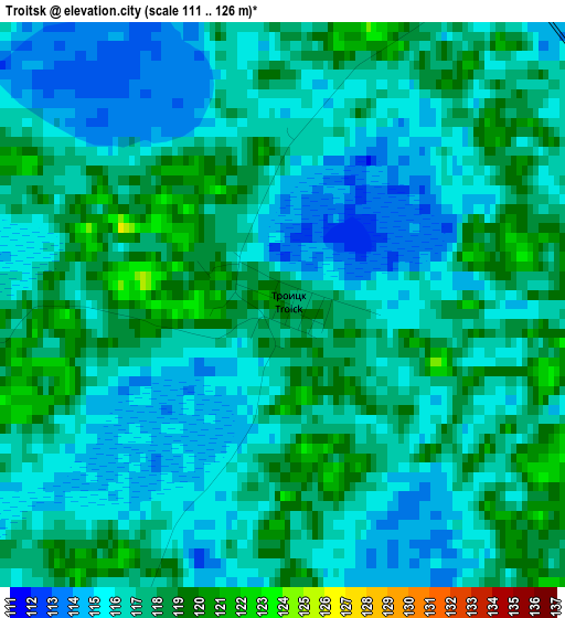
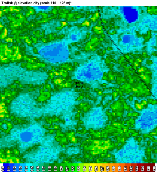
Below is the Elevation map of Troitsk, which displays elevation range with different colors. Scale of the first map is from 111 to 126 m (364 to 413 ft) with average elevation of 116.5 meters (=382 ft) [note 1]
These maps also provides idea of topography and contour of this city, they are displayed at different zoom levels. More info about maps, scale and edge coordinates you can find below images.
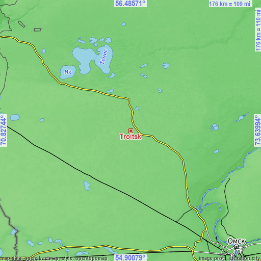
| \ | Map #1 | Map #2 | Topo.Map |
| Scale [m] | 111..126 m | 110..126 m | × |
| Scale [ft] | 364..413 ft | 361..413 ft | × |
| Average | 116.5 m = 382 ft | 117 m = 384 ft | × |
| Width | 5.51 km = 3.4 mi | 11.01 km = 6.8 mi | 176.2 km = 109.5 mi |
| Height | 5.51 km = 3.4 mi | 11.01 km = 6.8 mi | 176.2 km = 109.5 mi |
| ↑Max Latitude | 55.726036° | 55.750776° | 56.48571° |
| Latitude at center | 55.70128° | 55.70128° | 55.70128° |
| ↓Min Latitude | 55.676509° | 55.651722° | 54.90079° |
| ← Min Longitude | 72.189745° | 72.145799° | 70.82744° |
| Longitude center | 72.23369° | 72.23369° | 72.23369° |
| →Max Longitude | 72.277635° | 72.321581° | 73.63994° |
Nearby cities:
Cities around Troitsk sort by population:
• Nazyvayevsk elevation 123 m
57.2 km,  255°
255°
• Tyukalinsk 118 m
19.3 km,  353°
353°
• Lyubinskiy 114 m
67.4 km,  154°
154°
• Luzino 105 m
97.9 km, 148°
• Sargatskoye 84 m
79.9 km,  97°
97°
• Beregovoy 82 m
85.6 km,  133°
133°
• Vkhodnoy 97 m
102.3 km,  144°
144°
• Krutinka 105 m
56.4 km,  306°
306°
• Krutaya Gorka 110 m
72.6 km,  120°
120°
• Rostovka 119 m
41.4 km,  211°
211°
• Krasnyy Yar 82 m
67.1 km, 139°
• Krasnoyarka 92 m
69 km, 126°
Multilingual:
 En español:
Troitsk elevación 118 m.
 En France:
Troitsk élévation 118 m.


Sources and notes:
- [note 1] Map square and city borders are not equal. Map elevation data is calculated only from area inside that square.
- [src 1] Elevation data from geonames database provided with same terms of usage.
- [src 2] The elevation map of Troitsk is generated using elevation data from NASA's 3 arcsec (90m) resolution SRTM data.
- [src 3] Base (background) map © OpenStreetMap contributors tiles are generated by Geofabrik and OpenTopoMap.
Copyright & License:
This Troitsk Elevation Map is licensed under CC BY-SA. You may reuse any part from this page, if you give a proper credit by linking to this URL:
 More info on terms of use page.