Tsementnyy elevation
Tsementnyy (Sverdlovsk), Russia elevation is 257 meters and Tsementnyy elevation in feet is 843 ft above sea level [src 1]. Tsementnyy is a populated place (feature code) with elevation that is 58 meters (190 ft) bigger than average city elevation in Russia.
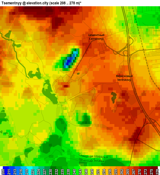
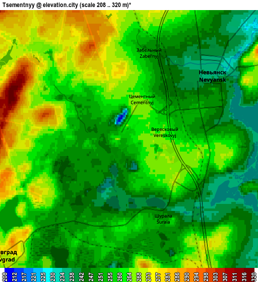
Below is the Elevation map of Tsementnyy, which displays elevation range with different colors. Scale of the first map is from 208 to 278 m (682 to 912 ft) with average elevation of 254.5 meters (=835 ft) [note 1]
These maps also provides idea of topography and contour of this city, they are displayed at different zoom levels. More info about maps, scale and edge coordinates you can find below images.
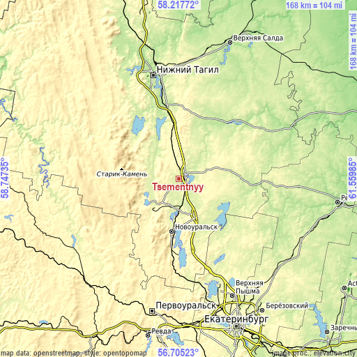
| \ | Map #1 | Map #2 | Topo.Map |
| Scale [m] | 208..278 m | 208..320 m | × |
| Scale [ft] | 682..912 ft | 682..1050 ft | × |
| Average | 254.5 m = 835 ft | 257.8 m = 846 ft | × |
| Width | 5.26 km = 3.3 mi | 10.51 km = 6.5 mi | 168.2 km = 104.5 mi |
| Height | 5.26 km = 3.3 mi | 10.51 km = 6.5 mi | 168.2 km = 104.5 mi |
| ↑Max Latitude | 57.492924° | 57.516533° | 58.21772° |
| Latitude at center | 57.4693° | 57.4693° | 57.4693° |
| ↓Min Latitude | 57.445661° | 57.422006° | 56.70523° |
| ← Min Longitude | 60.109655° | 60.065709° | 58.74735° |
| Longitude center | 60.1536° | 60.1536° | 60.1536° |
| →Max Longitude | 60.197545° | 60.241491° | 61.55985° |
Nearby cities:
Cities around Tsementnyy sort by population:
• Novoural’sk elevation 299 m
25.4 km,  189°
189°
• Nev’yansk 237 m
4.5 km,  49°
49°
• Kirovgrad 286 m
7.1 km,  231°
231°
• Verkhniy Tagil 264 m
16 km, 227°
• Verkh-Neyvinskiy 303 m
22.2 km,  182°
182°
• Nikolo-Pavlovskoye 209 m
35.4 km,  350°
350°
• Chernoistochinsk 221 m
34.1 km,  330°
330°
• Levikha 292 m
19.8 km,  310°
310°
• Neyvo-Rudyanka 252 m
13.9 km, 184°
• Novoasbest 274 m
31.4 km,  14°
14°
• Uralets 395 m
36.9 km, 305°
• Karpushikha 282 m
15.8 km,  283°
283°
Multilingual:
 En español:
Tsementnyy elevación 257 m.
 En France:
Tsementnyy élévation 257 m.
 Auf Deutsch:
Tsementnyy höhe über dem Meeresspiegel ist 257 m.

Sources and notes:
- [note 1] Map square and city borders are not equal. Map elevation data is calculated only from area inside that square.
- [src 1] Elevation data from geonames database provided with same terms of usage.
- [src 2] The elevation map of Tsementnyy is generated using elevation data from NASA's 3 arcsec (90m) resolution SRTM data.
- [src 3] Base (background) map © OpenStreetMap contributors tiles are generated by Geofabrik and OpenTopoMap.
Copyright & License:
This Tsementnyy Elevation Map is licensed under CC BY-SA. You may reuse any part from this page, if you give a proper credit by linking to this URL:
 More info on terms of use page.