Tuim elevation
Tuim (Khakasiya Republic), Russia elevation is 602 meters and Tuim elevation in feet is 1975 ft above sea level [src 1]. Tuim is a populated place (feature code) with elevation that is 403 meters (1322 ft) bigger than average city elevation in Russia.
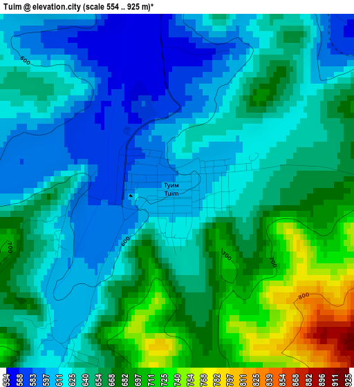
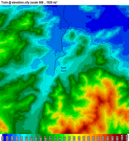
Below is the Elevation map of Tuim, which displays elevation range with different colors. Scale of the first map is from 554 to 925 m (1818 to 3035 ft) with average elevation of 644.6 meters (=2115 ft) [note 1]
These maps also provides idea of topography and contour of this city, they are displayed at different zoom levels. More info about maps, scale and edge coordinates you can find below images.
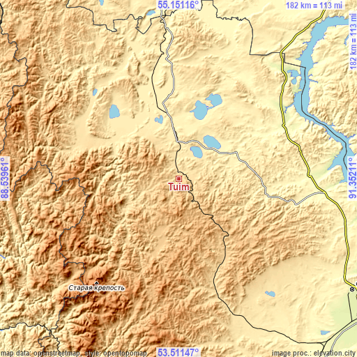
| \ | Map #1 | Map #2 | Topo.Map |
| Scale [m] | 554..925 m | 508..1025 m | × |
| Scale [ft] | 1818..3035 ft | 1667..3363 ft | × |
| Average | 644.6 m = 2115 ft | 673.4 m = 2209 ft | × |
| Width | 5.7 km = 3.5 mi | 11.39 km = 7.1 mi | 182.3 km = 113.3 mi |
| Height | 5.7 km = 3.5 mi | 11.39 km = 7.1 mi | 182.3 km = 113.3 mi |
| ↑Max Latitude | 54.365101° | 54.390697° | 55.15116° |
| Latitude at center | 54.33949° | 54.33949° | 54.33949° |
| ↓Min Latitude | 54.313863° | 54.288219° | 53.51147° |
| ← Min Longitude | 89.901915° | 89.857969° | 88.53961° |
| Longitude center | 89.94586° | 89.94586° | 89.94586° |
| →Max Longitude | 89.989805° | 90.033751° | 91.35211° |
Nearby cities:
Cities around Tuim sort by population:
• Abakan elevation 248 m
119.2 km,  125°
125°
• Chernogorsk 279 m
104.5 km,  123°
123°
• Uzhur 373 m
108.4 km,  356°
356°
• Ust’-Abakan 238 m
109.6 km, 120°
• Sorsk 721 m
42.2 km,  152°
152°
• Shira 485 m
16.9 km,  1°
1°
• Krasnoturansk 322 m
104.9 km,  91°
91°
• Bograd 426 m
58.7 km,  101°
101°
• Vershina Tei 961 m
121.7 km,  192°
192°
• Belogorsk 703 m
120.2 km,  308°
308°
• Kommunar 705 m
43 km,  271°
271°
• Biskamzha 599 m
102.7 km,  195°
195°
Multilingual:
 En español:
Tuim elevación 602 m.
 En France:
Tuim élévation 602 m.


Sources and notes:
- [note 1] Map square and city borders are not equal. Map elevation data is calculated only from area inside that square.
- [src 1] Elevation data from geonames database provided with same terms of usage.
- [src 2] The elevation map of Tuim is generated using elevation data from NASA's 3 arcsec (90m) resolution SRTM data.
- [src 3] Base (background) map © OpenStreetMap contributors tiles are generated by Geofabrik and OpenTopoMap.
Copyright & License:
This Tuim Elevation Map is licensed under CC BY-SA. You may reuse any part from this page, if you give a proper credit by linking to this URL:
 More info on terms of use page.